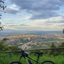
Monthathan Waterfall
Eine Fahrradroute, die in Chiang Mai, Chiang Mai Province, Thailand beginnt.
Übersicht
Über diese Route
This is a short and sweet bicycle tour from the arboretum at the end of Huay Kaew Rd. to the Monthathan waterfall. The road leads through the Doi Suthep forest. It is fairly steep and continuously paved, so it can be done by road bike or mountain bike. The 1 hour climb (on a knobby tire mountain bike) provides a good cardio exercise and ends at a beautiful spot in the forest where the multileveled Monthan waterfall begins. This is one of the few spots where National Park entrance fee has to be paid at the park gate. It's well worth it.
- -:--
- Dauer
- 5,8 km
- Distanz
- 116 m
- Aufstieg
- 544 m
- Abstieg
- ---
- Ø-Tempo
- ---
- Ø-Tempo
Routenqualität
Wegtypen und Untergründe entlang der Route
Wegtypen
Vielbefahrene Straße
3,7 km
(64 %)
Zufahrtsstraße
2 km
(34 %)
Untergründe
Befestigt
5,8 km
(100 %)
Asphalt
3,7 km
(64 %)
Beton
2 km
(34 %)
Highlights der Route
POIs entlang der Route
Interessanter Ort nach 2,3 km
Park Gate
Weiter mit Bikemap
Diese Radroute verwenden, bearbeiten oder herunterladen
Du möchtest Monthathan Waterfall fahren oder sie für deine eigene Reise anpassen? Folgendes kannst du mit dieser Bikemap-Route machen:
Gratis Funktionen
- Speichere diese Route als Favorit oder in einer Sammlung
- Kopiere & plane deine eigene Version dieser Route
- Synchronisiere deine Route mit Garmin oder Wahoo
Premium-Funktionen
Kostenlose Testversion für 3 Tage oder einmalige Zahlung. Mehr über Bikemap Premium.
- Navigiere diese Route auf iOS & Android
- Exportiere eine GPX / KML-Datei dieser Route
- Erstelle deinen individuellen Ausdruck (Jetzt kostenlos ausprobieren)
- Lade diese Route für die Offline-Navigation herunter
Entdecke weitere Premium-Funktionen.
Bikemap Premium aktivierenVon unserer Community
Chiang Mai: Andere beliebte Routen, die hier beginnen
 Chiang Mai
- Distanz
- 669,4 km
- Aufstieg
- 1.461 m
- Abstieg
- 1.461 m
- Standort
- Chiang Mai, Chiang Mai Province, Thailand
 straight to samoeng
- Distanz
- 41,2 km
- Aufstieg
- 1.028 m
- Abstieg
- 849 m
- Standort
- Chiang Mai, Chiang Mai Province, Thailand
 Chiangmai U to Doi Su Thep view point
- Distanz
- 18,1 km
- Aufstieg
- 404 m
- Abstieg
- 403 m
- Standort
- Chiang Mai, Chiang Mai Province, Thailand
 DoiSuthep
- Distanz
- 49,9 km
- Aufstieg
- 1.107 m
- Abstieg
- 1.109 m
- Standort
- Chiang Mai, Chiang Mai Province, Thailand
 MHS Loop
- Distanz
- 533,7 km
- Aufstieg
- 5.294 m
- Abstieg
- 5.289 m
- Standort
- Chiang Mai, Chiang Mai Province, Thailand
 Moderate Route in Chiang Mai
- Distanz
- 7,4 km
- Aufstieg
- 21 m
- Abstieg
- 18 m
- Standort
- Chiang Mai, Chiang Mai Province, Thailand
 Cycle in Thai 03 : Chiang Rai, Myanmar
- Distanz
- 263,6 km
- Aufstieg
- 781 m
- Abstieg
- 703 m
- Standort
- Chiang Mai, Chiang Mai Province, Thailand
 Phuping Palace
- Distanz
- 52,2 km
- Aufstieg
- 1.083 m
- Abstieg
- 1.098 m
- Standort
- Chiang Mai, Chiang Mai Province, Thailand
In der App öffnen


