CPR Lac d'Orta 2020/3
- 62,7 km
- 710 m
- 704 m
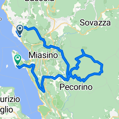
- Pettenasco, Piemont, Italien
Eine Fahrradroute, die in Pettenasco, Piemont, Italien beginnt.
Übersicht
Eine schöne Fahrt von etwa 80 km. Meistens fuhren wir über asphaltierte Straßen, wo möglich kleine und ruhige. Start in Pratolungo, fahre nach Agrano und dann in Richtung Omegna. Lass dies auf deiner linken Seite und folge den Schildern nach Granerolo. Es ist ein Anstieg, aber die Fahrt ist es wert, da du über eine schöne, kleine Straße bis zur Hauptstraße fährst. Nimm eine rechts in Richtung Verbania/Stresa. Kurz bevor du unter die Autobahn fährst, nimm die Straße auf der linken Seite (in Richtung Camping Piano Grande). Folge dieser bis du auf einer anderen Autobahn landest und gehe nach links. An der Kreuzung gehst du nach rechts und sofort danach nach links in Richtung Bieno. Vor dem Zentrum von Cambiasca nimm eine links und folge dann der Straße den ganzen Weg nach oben, vorbei an Cossogno, Ungiasca und Miazzina, bis du Alpe Pale erreichst. Nimm die Straße direkt links vom Restaurant, die unbefestigt ist. Die ersten paar Kilometer dieser Straße waren in Ordnung, aber die letzten eineinhalb Stunden/45 Minuten mussten wir zu Fuß gehen, da sie ganz mit Gras zugewachsen war.... Du kannst ein gutes Picknick an der Kapelle machen, bei der du ankommst. Danach geht es hinunter nach Caprezzo, Ramello und Cambiasca. Von dort kannst du denselben Weg zurück nehmen (wir folgten dem Wasser und übersprangen die Fahrt nach Granerolo).
Erstellt vor 12 Jahren
Weiter mit Bikemap
Du möchtest Pettenasco - Caprezzo (via Alpe Pala) - Pettenasco fahren oder sie für deine eigene Reise anpassen? Folgendes kannst du mit dieser Bikemap-Route machen:
Kostenlose Testversion für 3 Tage oder einmalige Zahlung. Mehr über Bikemap Premium.
Entdecke weitere Premium-Funktionen.
Bikemap Premium aktivierenVon unserer Community
In der App öffnen