

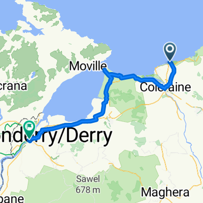
Portrush - Ballybogey - River Bann (35.32m/56.85km)
Eine Fahrradroute, die in Portrush, Nordirland, Vereinigtes Königreich beginnt.
Übersicht
Über diese Route
Our route heads South East from Portrush taking in the country lanes to the village of Ballyvogey. You then turn South West and continue your journey to the Eastern banks of the Lower River Bann where you turn Northwards and follow the road all the way to the University Town of Coleraine with the river never more than a few metres away from your left shoulder. This is a lovely and peaceful circuit which is relatively flat but long enough to justify a pint of the black stuff, a cake or both.
- -:--
- Dauer
- 56,9 km
- Distanz
- 211 m
- Aufstieg
- 211 m
- Abstieg
- ---
- Ø-Tempo
- ---
- Max. Höhe
Routenqualität
Wegtypen und Untergründe entlang der Route
Wegtypen
Straße
34,7 km
(61 %)
Ruhige Straße
10,2 km
(18 %)
Untergründe
Befestigt
46,1 km
(81 %)
Asphalt
46,1 km
(81 %)
Undefiniert
10,8 km
(19 %)
Weiter mit Bikemap
Diese Radroute verwenden, bearbeiten oder herunterladen
Du möchtest Portrush - Ballybogey - River Bann (35.32m/56.85km) fahren oder sie für deine eigene Reise anpassen? Folgendes kannst du mit dieser Bikemap-Route machen:
Gratis Funktionen
- Speichere diese Route als Favorit oder in einer Sammlung
- Kopiere & plane deine eigene Version dieser Route
- Synchronisiere deine Route mit Garmin oder Wahoo
Premium-Funktionen
Kostenlose Testversion für 3 Tage oder einmalige Zahlung. Mehr über Bikemap Premium.
- Navigiere diese Route auf iOS & Android
- Exportiere eine GPX / KML-Datei dieser Route
- Erstelle deinen individuellen Ausdruck (Jetzt kostenlos ausprobieren)
- Lade diese Route für die Offline-Navigation herunter
Entdecke weitere Premium-Funktionen.
Bikemap Premium aktivierenVon unserer Community
Portrush: Andere beliebte Routen, die hier beginnen
 Strand Road 2 do Castlehill Way 8
- Distanz
- 27,6 km
- Aufstieg
- 133 m
- Abstieg
- 85 m
- Standort
- Portrush, Nordirland, Vereinigtes Königreich
 Portrush - Bushmills Circuit (17.55m/28km)
- Distanz
- 28,3 km
- Aufstieg
- 193 m
- Abstieg
- 193 m
- Standort
- Portrush, Nordirland, Vereinigtes Königreich
 5 giorno
- Distanz
- 74,8 km
- Aufstieg
- 417 m
- Abstieg
- 423 m
- Standort
- Portrush, Nordirland, Vereinigtes Königreich
 Portrush - Mussenden Temple (23.87m/38.42km)
- Distanz
- 38,5 km
- Aufstieg
- 216 m
- Abstieg
- 214 m
- Standort
- Portrush, Nordirland, Vereinigtes Königreich
 Portrush to Bushmills to Portrush
- Distanz
- 20,4 km
- Aufstieg
- 209 m
- Abstieg
- 208 m
- Standort
- Portrush, Nordirland, Vereinigtes Königreich
 Portrush - Castlerock
- Distanz
- 20,1 km
- Aufstieg
- 151 m
- Abstieg
- 159 m
- Standort
- Portrush, Nordirland, Vereinigtes Königreich
 Portrush - Portstewart Strand (8.7m/14km)
- Distanz
- 14 km
- Aufstieg
- 91 m
- Abstieg
- 93 m
- Standort
- Portrush, Nordirland, Vereinigtes Königreich
 Day 15_ Portrush - Bushmills
- Distanz
- 19,7 km
- Aufstieg
- 248 m
- Abstieg
- 248 m
- Standort
- Portrush, Nordirland, Vereinigtes Königreich
In der App öffnen