

Hot Doggett Metric Century (2009)
Eine Fahrradroute, die in Mars Hill, North Carolina, Vereinigte Staaten beginnt.
Übersicht
Über diese Route
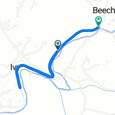
Die 100K-Strecke beginnt auf der Highway 213 und biegt auf die Bone Camp Road (liebevoll bekannt als Bone Crusher) ab. Sei vorsichtig beim Abstieg zur East Fork Road. Als Nächstes durchqueren wir die Grapevine Community mit einem herausfordernden dreimeilenlangen Anstieg und einigen unglaublichen Ausblicken. Danach geht es hinunter nach Big Laurel mit weiteren großartigen Ausblicken entlang des Laurel Creek.
Während wir in der Big Laurel Community sind, passieren wir die Revere- und Spill Corn-Communities auf dem Weg zum historischen Shelton Laurel. In Shelton Laurel steigen wir zum Gipfel des Devils Fork auf, einschließlich eines 1/8-Meilen-Abschnitts mit 15% Steigung. Oben ist der Appalachian Trail und eine Raststätte!
Beim Abstieg nach Tennessee erwarten uns weitere großartige Ausblicke. Sobald wir in Flag Pond sind, steht ein herausfordernder fünf Meilen langer Anstieg nach Sams Gap zu einer weiteren Raststation bevor. Ein schreiender Abstieg zurück nach North Carolina steht bevor, mit einem letzten Anstieg über den Murray Mountain und einem weiteren schreienden Abstieg nach Mars Hill.
- -:--
- Dauer
- 103 km
- Distanz
- 2.651 m
- Aufstieg
- 2.482 m
- Abstieg
- ---
- Ø-Tempo
- 973 m
- Max. Höhe
Routenqualität
Wegtypen und Untergründe entlang der Route
Wegtypen
Ruhige Straße
48,4 km
(47 %)
Zufahrtsstraße
4,1 km
(4 %)
Undefiniert
50,4 km
(49 %)
Untergründe
Befestigt
67,9 km
(66 %)
Unbefestigt
5,1 km
(5 %)
Asphalt
66,9 km
(65 %)
Schotter
4,1 km
(4 %)
Weiter mit Bikemap
Diese Radroute verwenden, bearbeiten oder herunterladen
Du möchtest Hot Doggett Metric Century (2009) fahren oder sie für deine eigene Reise anpassen? Folgendes kannst du mit dieser Bikemap-Route machen:
Gratis Funktionen
- Speichere diese Route als Favorit oder in einer Sammlung
- Kopiere & plane deine eigene Version dieser Route
- Teile sie in Etappen ein, um eine mehrtägige Tour zu erstellen
- Synchronisiere deine Route mit Garmin oder Wahoo
Premium-Funktionen
Kostenlose Testversion für 3 Tage oder einmalige Zahlung. Mehr über Bikemap Premium.
- Navigiere diese Route auf iOS & Android
- Exportiere eine GPX / KML-Datei dieser Route
- Erstelle deinen individuellen Ausdruck (Jetzt kostenlos ausprobieren)
- Lade diese Route für die Offline-Navigation herunter
Entdecke weitere Premium-Funktionen.
Bikemap Premium aktivierenVon unserer Community
Mars Hill: Andere beliebte Routen, die hier beginnen
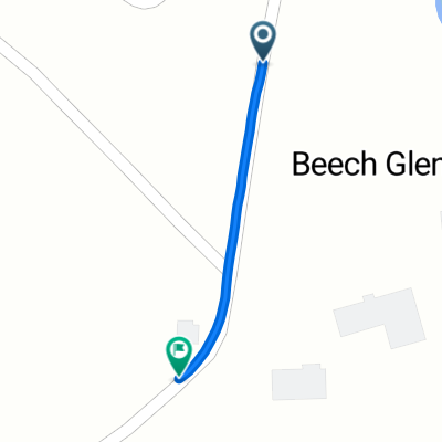
 Beech Glen Road to Beech Glen Road
- Distanz
- 2,5 km
- Aufstieg
- 52 m
- Abstieg
- 12 m
- Standort
- Mars Hill, North Carolina, Vereinigte Staaten
 Beech Glen Road to Blue Herron Road
- Distanz
- 0,6 km
- Aufstieg
- 42 m
- Abstieg
- 0 m
- Standort
- Mars Hill, North Carolina, Vereinigte Staaten
 North Main Street 114, Mars Hill to North Main Street 114, Mars Hill
- Distanz
- 34 km
- Aufstieg
- 462 m
- Abstieg
- 462 m
- Standort
- Mars Hill, North Carolina, Vereinigte Staaten
 Hot Doggett Metric Century (2009)
- Distanz
- 103 km
- Aufstieg
- 2.651 m
- Abstieg
- 2.482 m
- Standort
- Mars Hill, North Carolina, Vereinigte Staaten
In der App öffnen