Cassis - Barjols
Eine Fahrradroute, die in Cassis, Provence-Alpes-Côte d'Azur Region, France beginnt.
Übersicht
Über diese Route
2.Etappe meiner Frankreich-Reise '08:
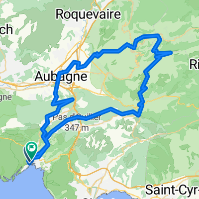
<table style="border-collapse: collapse; width: 98pt;" border="0" cellspacing="0" cellpadding="0" width="131"> <tbody> <tr style="height: 12.75pt;" height="17"> <td class="xl24" style="height: 12.75pt; width: 98pt;" width="131" height="17">
Cassis
</td> </tr> </tbody> </table>
<table style="border-collapse: collapse; width: 98pt;" border="0" cellspacing="0" cellpadding="0" width="131"> <tbody> <tr style="height: 12.75pt;" height="17"> <td class="xl25" style="height: 12.75pt;" height="17">
Mont de la Saoupe
</td> </tr> </tbody> </table> <table style="border-collapse: collapse; width: 98pt;" border="0" cellspacing="0" cellpadding="0" width="131"> <tbody> <tr style="height: 12.75pt;" height="17"> <td class="xl25" style="height: 12.75pt;" height="17">
Grde de Tête
</td> </tr> </tbody> </table> <table style="border-collapse: collapse; width: 98pt;" border="0" cellspacing="0" cellpadding="0" width="131"> <tbody> <tr style="height: 12.75pt;" height="17"> <td class="xl24" style="height: 12.75pt;" height="17">
La Ciotat
</td> </tr> </tbody> </table> <table style="border-collapse: collapse; width: 98pt;" border="0" cellspacing="0" cellpadding="0" width="131"> <tbody> <tr style="height: 12.75pt;" height="17"> <td class="xl24" style="height: 12.75pt;" height="17">
Ceyreste
</td> </tr> </tbody> </table> <table style="border-collapse: collapse; width: 98pt;" border="0" cellspacing="0" cellpadding="0" width="131"> <tbody> <tr style="height: 12.75pt;" height="17"> <td class="xl24" style="height: 12.75pt;" height="17">
Mauregard
</td> </tr> </tbody> </table> <table style="border-collapse: collapse; width: 98pt;" border="0" cellspacing="0" cellpadding="0" width="131"> <tbody> <tr style="height: 12.75pt;" height="17"> <td class="xl24" style="height: 12.75pt;" height="17">
Le Grd Caunet
</td> </tr> </tbody> </table> <table style="border-collapse: collapse; width: 98pt;" border="0" cellspacing="0" cellpadding="0" width="131"> <tbody> <tr style="height: 12.75pt;" height="17"> <td class="xl24" style="height: 12.75pt;" height="17">
Richtung Pinval / Gemenos
</td> </tr> </tbody> </table> <table style="border-collapse: collapse; width: 98pt;" border="0" cellspacing="0" cellpadding="0" width="131"> <tbody> <tr style="height: 12.75pt;" height="17"> <td class="xl24" style="height: 12.75pt;" height="17">
Gemenos
</td> </tr> </tbody> </table>
<table style="border-collapse: collapse; width: 98pt;" border="0" cellspacing="0" cellpadding="0" width="131"> <tbody> <tr style="height: 12.75pt;" height="17"> <td class="xl24" style="height: 12.75pt;" height="17"></td> </tr> </tbody> </table>
<table style="border-collapse: collapse; width: 98pt;" border="0" cellspacing="0" cellpadding="0" width="131"> <tbody> <tr style="height: 12.75pt;" height="17"> <td class="xl25" style="height: 12.75pt;" height="17">
Col d'Espigoulier
</td> </tr> </tbody> </table> <table style="border-collapse: collapse; width: 98pt;" border="0" cellspacing="0" cellpadding="0" width="131"> <tbody> <tr style="height: 12.75pt;" height="17"> <td class="xl24" style="height: 12.75pt;" height="17">
Plan-D'Aups
</td> </tr> </tbody> </table> <table style="border-collapse: collapse; width: 98pt;" border="0" cellspacing="0" cellpadding="0" width="131"> <tbody> <tr style="height: 12.75pt;" height="17"> <td class="xl24" style="height: 12.75pt;" height="17">
Mazaugues
</td> </tr> </tbody> </table> <table style="border-collapse: collapse; width: 98pt;" border="0" cellspacing="0" cellpadding="0" width="131"> <tbody> <tr style="height: 12.75pt;" height="17"> <td class="xl24" style="height: 12.75pt;" height="17"></td> </tr> </tbody> </table> <table style="border-collapse: collapse; width: 98pt;" border="0" cellspacing="0" cellpadding="0" width="131"> <tbody> <tr style="height: 12.75pt;" height="17"> <td class="xl24" style="height: 12.75pt;" height="17">
Les Censiés
</td> </tr> </tbody> </table> <table style="border-collapse: collapse; width: 98pt;" border="0" cellspacing="0" cellpadding="0" width="131"> <tbody> <tr style="height: 12.75pt;" height="17"> <td class="xl24" style="height: 12.75pt;" height="17">
Bras
</td> </tr> </tbody> </table> <table style="border-collapse: collapse; width: 98pt;" border="0" cellspacing="0" cellpadding="0" width="131"> <tbody> <tr style="height: 13.5pt;" height="18"> <td class="xl24" style="height: 13.5pt;" height="18">
Saint Estève
</td> </tr> </tbody> </table> <table style="border-collapse: collapse; width: 98pt;" border="0" cellspacing="0" cellpadding="0" width="131"> <tbody> <tr style="height: 12.75pt;" height="17"> <td class="xl24" style="height: 12.75pt;" height="17">
Brue Auriac
</td> </tr> </tbody> </table> <table style="border-collapse: collapse; width: 98pt;" border="0" cellspacing="0" cellpadding="0" width="131"> <tbody> <tr style="height: 12.75pt;" height="17"> <td class="xl24" style="height: 12.75pt;" height="17">
Barjols
</td> </tr> </tbody> </table>
<br />
<table style="border-collapse: collapse; width: 98pt;" border="0" cellspacing="0" cellpadding="0" width="131"> <tbody> </tbody> </table>
- -:--
- Dauer
- 116,9 km
- Distanz
- 1.705 m
- Aufstieg
- 1.542 m
- Abstieg
- ---
- Ø-Tempo
- ---
- Ø-Tempo
Weiter mit Bikemap
Diese Radroute verwenden, bearbeiten oder herunterladen
Du möchtest Cassis - Barjols fahren oder sie für deine eigene Reise anpassen? Folgendes kannst du mit dieser Bikemap-Route machen:
Gratis Funktionen
- Speichere diese Route als Favorit oder in einer Sammlung
- Kopiere & plane deine eigene Version dieser Route
- Synchronisiere deine Route mit Garmin oder Wahoo
Premium-Funktionen
Kostenlose Testversion für 3 Tage oder einmalige Zahlung. Mehr über Bikemap Premium.
- Navigiere diese Route auf iOS & Android
- Exportiere eine GPX / KML-Datei dieser Route
- Erstelle deinen individuellen Ausdruck (Jetzt kostenlos ausprobieren)
- Lade diese Route für die Offline-Navigation herunter
Entdecke weitere Premium-Funktionen.
Bikemap Premium aktivierenVon unserer Community
Cassis: Andere beliebte Routen, die hier beginnen
- La Ciotat-callanques_cassis
- Distanz
- 30,6 km
- Aufstieg
- 879 m
- Abstieg
- 880 m
- Standort
- Cassis, Provence-Alpes-Côte d’Azur, Frankreich
- callanques_cassis
- Distanz
- 30,6 km
- Aufstieg
- 916 m
- Abstieg
- 915 m
- Standort
- Cassis, Provence-Alpes-Côte d’Azur, Frankreich
- Cassis-Nice en vélo
- Distanz
- 299,6 km
- Aufstieg
- 1.077 m
- Abstieg
- 1.076 m
- Standort
- Cassis, Provence-Alpes-Côte d’Azur, Frankreich
- ride from Cassis to Marseille
- Distanz
- 21,4 km
- Aufstieg
- 249 m
- Abstieg
- 395 m
- Standort
- Cassis, Provence-Alpes-Côte d’Azur, Frankreich
- Cassis - Barjols
- Distanz
- 116,9 km
- Aufstieg
- 1.705 m
- Abstieg
- 1.542 m
- Standort
- Cassis, Provence-Alpes-Côte d’Azur, Frankreich
- 2016J20Soir : Casino de Cassis
- Distanz
- 1,7 km
- Aufstieg
- 9 m
- Abstieg
- 85 m
- Standort
- Cassis, Provence-Alpes-Côte d’Azur, Frankreich
- Provence 2009 - Tappa 07 (proposta)
- Distanz
- 91,7 km
- Aufstieg
- 929 m
- Abstieg
- 931 m
- Standort
- Cassis, Provence-Alpes-Côte d’Azur, Frankreich
- calanque d’en vau
- Distanz
- 16 km
- Aufstieg
- 332 m
- Abstieg
- 326 m
- Standort
- Cassis, Provence-Alpes-Côte d’Azur, Frankreich
In der App öffnen