

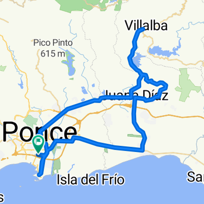
Ruta: Ponce-Collores-Villalba-Ponce
Eine Fahrradroute, die in Ponce, Ponce Municipio, Puerto Rico beginnt.
Übersicht
Über diese Route
ROUTE: Ponce-Collores- Villalba-Juana Díaz-Ponce Start point:Med Centro, Ponce Farthest Point:Downtown Villalba End Point:Med Centro, Ponce Distance:34mi/55km Total Time:3:30 hr Moving Time:2:40 hr Avg Moving Speed:13 mph Elevation Gain:1,750 ft Calories:1,600 to 2,000
ROUTE DESCRIPTION: This is a good route for avid cyclists who are not necessarily aiming to do competitive cycling. First 10 miles are comprised by flat and mild hills. Following 4 miles are is a more steep climbing to the highest point of the route, followed by a2 mile descent. The rest is a hilly roller coaster throughout the route. Last 5 miles is a very moderate descent passing through downtown Ponce until the End Point. Route is all paved and is suitable for either MTB or Road bikes. However, be aware that roads may have unknown damaged pave at times. This is a very enjoyable route throughout countryside PR. Cyclists moderately trained should be able to complete it with ease. Great to be done with pals and share a great time together.
- -:--
- Dauer
- 55,2 km
- Distanz
- 388 m
- Aufstieg
- 386 m
- Abstieg
- ---
- Ø-Tempo
- ---
- Max. Höhe
Routenqualität
Wegtypen und Untergründe entlang der Route
Wegtypen
Straße
26,6 km
(48 %)
Vielbefahrene Straße
22,5 km
(41 %)
Untergründe
Befestigt
4,1 km
(7 %)
Asphalt
4,1 km
(7 %)
Undefiniert
51,2 km
(93 %)
Weiter mit Bikemap
Diese Radroute verwenden, bearbeiten oder herunterladen
Du möchtest Ruta: Ponce-Collores-Villalba-Ponce fahren oder sie für deine eigene Reise anpassen? Folgendes kannst du mit dieser Bikemap-Route machen:
Gratis Funktionen
- Speichere diese Route als Favorit oder in einer Sammlung
- Kopiere & plane deine eigene Version dieser Route
- Synchronisiere deine Route mit Garmin oder Wahoo
Premium-Funktionen
Kostenlose Testversion für 3 Tage oder einmalige Zahlung. Mehr über Bikemap Premium.
- Navigiere diese Route auf iOS & Android
- Exportiere eine GPX / KML-Datei dieser Route
- Erstelle deinen individuellen Ausdruck (Jetzt kostenlos ausprobieren)
- Lade diese Route für die Offline-Navigation herunter
Entdecke weitere Premium-Funktionen.
Bikemap Premium aktivierenVon unserer Community
Ponce: Andere beliebte Routen, die hier beginnen
 Med Centro-Collores-Villaba-JDiaz-Med Centro
- Distanz
- 55,2 km
- Aufstieg
- 393 m
- Abstieg
- 390 m
- Standort
- Ponce, Ponce Municipio, Puerto Rico
 MED BIKE RALLY SHORT ROUTE
- Distanz
- 24,6 km
- Aufstieg
- 94 m
- Abstieg
- 92 m
- Standort
- Ponce, Ponce Municipio, Puerto Rico
 Light Workout
- Distanz
- 4,7 km
- Aufstieg
- 25 m
- Abstieg
- 26 m
- Standort
- Ponce, Ponce Municipio, Puerto Rico
 MBR 2014 - Larga Mountain Bike (Ruta A)
- Distanz
- 83,6 km
- Aufstieg
- 536 m
- Abstieg
- 536 m
- Standort
- Ponce, Ponce Municipio, Puerto Rico
 MED BIKE RALLY LONG ROUTE STREET BIKE
- Distanz
- 69,7 km
- Aufstieg
- 434 m
- Abstieg
- 434 m
- Standort
- Ponce, Ponce Municipio, Puerto Rico
 MBR - Ruta Larga - 50M-80K
- Distanz
- 79,5 km
- Aufstieg
- 418 m
- Abstieg
- 417 m
- Standort
- Ponce, Ponce Municipio, Puerto Rico
 Ruta: Ponce-Collores-Villalba-Ponce
- Distanz
- 55,2 km
- Aufstieg
- 388 m
- Abstieg
- 386 m
- Standort
- Ponce, Ponce Municipio, Puerto Rico
 Martes De Bicicleta
- Distanz
- 13,4 km
- Aufstieg
- 22 m
- Abstieg
- 21 m
- Standort
- Ponce, Ponce Municipio, Puerto Rico
In der App öffnen