

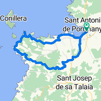
CALA JONDAL
Eine Fahrradroute, die in Sant Antoni de Portmany, Balearische Inseln, Spanien beginnt.
Übersicht
Über diese Route
<div> This route is designed for lovers of countryside and mountain. It is a tour</div> <div> that requires us to have a good level of cycling proficiency and proven</div> <div> physical fitness. That said, we enjoy a journey that shows us the interior</div> <div> of the island's far southwest, introducing us to traditional crops,</div> <div> impressive views and winding lanes while we pass through woods and</div> <div> fields which, especially in spring, overflow with colour and Mediterranean</div> <div> essence.</div> <div> We begin by pedalling along asphalt but immediately exit from the paved</div> <div> route and immerse ourselves in a network of paths, tracks and trails that</div> <div> we do not leave until we have almost finished.</div> <div> During the almost 40-kilometres route we experience an approximate</div> <div> 900 metres' difference in altitude which we tackle at two accessible</div> <div> climbs, first, Capelleta, and second, Sa Talaia, although we do not arrive</div> <div> at their summits.</div> <div> Halfway through the journey -if the weather is right- it is almost</div> <div> impossible not to make the most of the brilliant waters of Cala Jondal or</div> <div> Porroig and take a refreshing dip. Afterwards, we climb halfway up the</div> <div> mountain of Sa Talaia, crossing impressive valleys full of local flora and</div> <div> fauna, and return to Sant Antoni through small, pretty fields of crops in</div> <div> more relaxing terrain.</div>
- -:--
- Dauer
- 38 km
- Distanz
- 651 m
- Aufstieg
- 654 m
- Abstieg
- ---
- Ø-Tempo
- ---
- Max. Höhe
Weiter mit Bikemap
Diese Radroute verwenden, bearbeiten oder herunterladen
Du möchtest CALA JONDAL fahren oder sie für deine eigene Reise anpassen? Folgendes kannst du mit dieser Bikemap-Route machen:
Gratis Funktionen
- Speichere diese Route als Favorit oder in einer Sammlung
- Kopiere & plane deine eigene Version dieser Route
- Synchronisiere deine Route mit Garmin oder Wahoo
Premium-Funktionen
Kostenlose Testversion für 3 Tage oder einmalige Zahlung. Mehr über Bikemap Premium.
- Navigiere diese Route auf iOS & Android
- Exportiere eine GPX / KML-Datei dieser Route
- Erstelle deinen individuellen Ausdruck (Jetzt kostenlos ausprobieren)
- Lade diese Route für die Offline-Navigation herunter
Entdecke weitere Premium-Funktionen.
Bikemap Premium aktivierenVon unserer Community
Sant Antoni de Portmany: Andere beliebte Routen, die hier beginnen
 Ibiza. Vuelta cicloturista. Etapa 3 (84km)
- Distanz
- 84,5 km
- Aufstieg
- 640 m
- Abstieg
- 643 m
- Standort
- Sant Antoni de Portmany, Balearische Inseln, Spanien
 Sant Antoni de Portmany til Denia
- Distanz
- 106,7 km
- Aufstieg
- 0 m
- Abstieg
- 0 m
- Standort
- Sant Antoni de Portmany, Balearische Inseln, Spanien
 Trasa nr 8
- Distanz
- 26,7 km
- Aufstieg
- 357 m
- Abstieg
- 358 m
- Standort
- Sant Antoni de Portmany, Balearische Inseln, Spanien
 San Antonio - Formentera - Aeropuerto
- Distanz
- 143,5 km
- Aufstieg
- 483 m
- Abstieg
- 491 m
- Standort
- Sant Antoni de Portmany, Balearische Inseln, Spanien
 X Vuelta Cicloturismo Ibiza - 2ª etapa
- Distanz
- 101,5 km
- Aufstieg
- 982 m
- Abstieg
- 977 m
- Standort
- Sant Antoni de Portmany, Balearische Inseln, Spanien
 CALA JONDAL
- Distanz
- 38 km
- Aufstieg
- 651 m
- Abstieg
- 654 m
- Standort
- Sant Antoni de Portmany, Balearische Inseln, Spanien
 X vuelta cicloturismo Ibiza - 1ª etapa
- Distanz
- 77,3 km
- Aufstieg
- 528 m
- Abstieg
- 534 m
- Standort
- Sant Antoni de Portmany, Balearische Inseln, Spanien
 Cala de Bou - Corona - Buscastell . Cala de Bou
- Distanz
- 29,6 km
- Aufstieg
- 326 m
- Abstieg
- 327 m
- Standort
- Sant Antoni de Portmany, Balearische Inseln, Spanien
In der App öffnen