

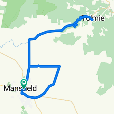
Mansfield to Buller climb
Eine Fahrradroute, die in Mansfield, Victoria, Australien beginnt.
Übersicht
Über diese Route
Also hast du gerade die letzte Tour gesehen und möchtest dich ein bisschen mehr herausfordern als bei der Beach Road Fahrt. Dies ist eine perfekte Fahrt, um dich aus deiner Komfortzone zu holen, ohne zu verrückt zu sein. Es sind 47 km von der ruhigen Kleinstadt Mansfield bis zum Gipfel von Buller. Die letzten 16 km werden dir die Herausforderung bieten, die du suchst. Sorge dafür, dass du noch etwas Kraft in den Beinen hast, um nach Mansfield zurückzukehren. Der Anstieg steigt 921 vertikale Meter auf der Mt Buller Tourest Straße und wird deine Entschlossenheit vom ersten Meter an prüfen. Der durchschnittliche Anstieg beträgt 6 %, aber in den steilsten Abschnitten geht es bis zu 13 % bergauf. Nach einem harten Aufstieg kannst du die atemberaubenden Ausblicke auf das umliegende Hochland genießen. Halte unbedingt im Dorfhotel an und gönn dir etwas zu essen, bevor du die super schnelle Abfahrt in Angriff nimmst. Du wirst es lieben, 16 km nicht treten zu müssen.
- -:--
- Dauer
- 47,2 km
- Distanz
- 1.376 m
- Aufstieg
- 148 m
- Abstieg
- ---
- Ø-Tempo
- ---
- Max. Höhe
Routenqualität
Wegtypen und Untergründe entlang der Route
Wegtypen
Pfad
1,4 km
(3 %)
Zufahrtsstraße
0,9 km
(2 %)
Undefiniert
44,9 km
(95 %)
Untergründe
Befestigt
45,3 km
(96 %)
Unbefestigt
0,9 km
(2 %)
Asphalt
32,6 km
(69 %)
Befestigt (undefiniert)
12,7 km
(27 %)
Weiter mit Bikemap
Diese Radroute verwenden, bearbeiten oder herunterladen
Du möchtest Mansfield to Buller climb fahren oder sie für deine eigene Reise anpassen? Folgendes kannst du mit dieser Bikemap-Route machen:
Gratis Funktionen
- Speichere diese Route als Favorit oder in einer Sammlung
- Kopiere & plane deine eigene Version dieser Route
- Synchronisiere deine Route mit Garmin oder Wahoo
Premium-Funktionen
Kostenlose Testversion für 3 Tage oder einmalige Zahlung. Mehr über Bikemap Premium.
- Navigiere diese Route auf iOS & Android
- Exportiere eine GPX / KML-Datei dieser Route
- Erstelle deinen individuellen Ausdruck (Jetzt kostenlos ausprobieren)
- Lade diese Route für die Offline-Navigation herunter
Entdecke weitere Premium-Funktionen.
Bikemap Premium aktivierenVon unserer Community
Mansfield: Andere beliebte Routen, die hier beginnen
 Mansfield to bonnie doon return
- Distanz
- 41 km
- Aufstieg
- 165 m
- Abstieg
- 168 m
- Standort
- Mansfield, Victoria, Australien
 Tolmie + Barwhite Loop
- Distanz
- 61,5 km
- Aufstieg
- 578 m
- Abstieg
- 578 m
- Standort
- Mansfield, Victoria, Australien
 Barwite Loop
- Distanz
- 20,8 km
- Aufstieg
- 193 m
- Abstieg
- 181 m
- Standort
- Mansfield, Victoria, Australien
 Day 2 - Leg 1b2c - Fat Tony , the Growler andYarck
- Distanz
- 63,1 km
- Aufstieg
- 392 m
- Abstieg
- 500 m
- Standort
- Mansfield, Victoria, Australien
 Mansfield south loop
- Distanz
- 49,6 km
- Aufstieg
- 270 m
- Abstieg
- 267 m
- Standort
- Mansfield, Victoria, Australien
 Mansfield Barwite Tolmie Mansfield Loop
- Distanz
- 47,3 km
- Aufstieg
- 647 m
- Abstieg
- 648 m
- Standort
- Mansfield, Victoria, Australien
 Mansfield 120 Km Loop
- Distanz
- 125,4 km
- Aufstieg
- 1.493 m
- Abstieg
- 1.493 m
- Standort
- Mansfield, Victoria, Australien
 Mansfield to Kinglake
- Distanz
- 136,4 km
- Aufstieg
- 1.005 m
- Abstieg
- 770 m
- Standort
- Mansfield, Victoria, Australien
In der App öffnen