

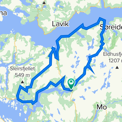
Rock cycling in Haugsdalen and Engleberget
Eine Fahrradroute, die in Mo, Hordaland, Norwegen beginnt.
Übersicht
Über diese Route
Diese Tour führt über Singletrails und einige Spielplätze für Rockcycling.
Fahre bis zum Ende der Forststraße am Svartavanet im Haugsdalen-Tal. Du kannst mit dem Fahrrad fahren, mit dem Auto fahren oder einen Lift von Matre aus nehmen, etwa eine Stunde nördlich von Bergen.
Fahre bergab und nimm links. Folge einem Singletrail und dann deinem eigenen Weg durch die Natur und auf Felsen hinunter zur Straße. Folge der Straße zurück 700 m und bieg links ab. Verlasse die Straße kurz vor der Brücke, und ein Spielplatz mit weichem Fels liegt vor dir. Du kannst beiden Seiten des Flusses folgen, normalerweise überquere ich den Fluss eine kurze Strecke unterhalb der Brücke und folge dann der rechten Seite.
Je nach Wasserstand des Sees überquerst du die Nordseite des Sees. Wenn er voll ist, ist es vielleicht am einfachsten, den Hügel hinaufzuklettern. Normalerweise setzt du deine Fahrt bis zu einem neuen Spielplatz mit weichen Felsen fort, bis du die Straße erreichst.
Folge der Straße 2 km nach Süden, wo es möglich ist, einen kurzen Abstecher nach links zu machen.
Dann verlasse die Straße nach 300 m erneut, und der Spielplatz am Engleberget liegt vor dir. Finde deinen Weg über die Felsen hinunter zum See. Folge der linken/östlichen Seite um den See herum. Im inneren Teil kannst du dir den Schwierigkeitsgrad zum Spielen selbst aussuchen.
Auf dem letzten Teil zurück zur Straße gibt es flache, glatte Felsen.
Ein vollgefedertes Bike wird dringend empfohlen. Verleih: www.bergfritid.no
- -:--
- Dauer
- 11,5 km
- Distanz
- 557 m
- Aufstieg
- 694 m
- Abstieg
- ---
- Ø-Tempo
- ---
- Max. Höhe

Weiter mit Bikemap
Diese Radroute verwenden, bearbeiten oder herunterladen
Du möchtest Rock cycling in Haugsdalen and Engleberget fahren oder sie für deine eigene Reise anpassen? Folgendes kannst du mit dieser Bikemap-Route machen:
Gratis Funktionen
- Speichere diese Route als Favorit oder in einer Sammlung
- Kopiere & plane deine eigene Version dieser Route
- Synchronisiere deine Route mit Garmin oder Wahoo
Premium-Funktionen
Kostenlose Testversion für 3 Tage oder einmalige Zahlung. Mehr über Bikemap Premium.
- Navigiere diese Route auf iOS & Android
- Exportiere eine GPX / KML-Datei dieser Route
- Erstelle deinen individuellen Ausdruck (Jetzt kostenlos ausprobieren)
- Lade diese Route für die Offline-Navigation herunter
Entdecke weitere Premium-Funktionen.
Bikemap Premium aktivierenVon unserer Community
Mo: Andere beliebte Routen, die hier beginnen
 BF5 Matre Bjordal Ortnevik
- Distanz
- 59,4 km
- Aufstieg
- 3.145 m
- Abstieg
- 3.126 m
- Standort
- Mo, Hordaland, Norwegen
 Rock cycling in Haugsdalen and Engleberget
- Distanz
- 11,5 km
- Aufstieg
- 557 m
- Abstieg
- 694 m
- Standort
- Mo, Hordaland, Norwegen
 Stølsheimen Vest
- Distanz
- 152,3 km
- Aufstieg
- 1.505 m
- Abstieg
- 1.504 m
- Standort
- Mo, Hordaland, Norwegen
 Stordalen: Anleggsveien
- Distanz
- 10,6 km
- Aufstieg
- 263 m
- Abstieg
- 348 m
- Standort
- Mo, Hordaland, Norwegen
 BF1 Matresdalen
- Distanz
- 4,8 km
- Aufstieg
- 759 m
- Abstieg
- 499 m
- Standort
- Mo, Hordaland, Norwegen
 BF3 Anleggsveien Stordalen
- Distanz
- 10,6 km
- Aufstieg
- 355 m
- Abstieg
- 440 m
- Standort
- Mo, Hordaland, Norwegen
 Matre - Bjordal
- Distanz
- 34,2 km
- Aufstieg
- 1.977 m
- Abstieg
- 1.977 m
- Standort
- Mo, Hordaland, Norwegen
 Stølsheimen Vest: Fjordsykkelruta
- Distanz
- 217,5 km
- Aufstieg
- 2.041 m
- Abstieg
- 2.041 m
- Standort
- Mo, Hordaland, Norwegen
In der App öffnen