

NL The Rhine Cycle Route
Eine Fahrradroute, die in Andermatt, Kanton Uri, Schweiz beginnt.
Übersicht
Über diese Route
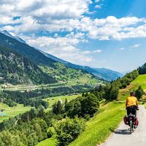
The Rhine Cycle Route is about 1,360 meters long and leads you through five countries. The track starts in the Swiss alps - the headwater area of the Rhine. Then it passes Austria, France and Germany. The route ends in Rotterdam in the Netherlands where the Rhine flows into the North Sea. (cloned from route 2567738)
- -:--
- Dauer
- 1.352,1 km
- Distanz
- 88 m
- Aufstieg
- 1.523 m
- Abstieg
- ---
- Ø-Tempo
- ---
- Max. Höhe
Routenqualität
Wegtypen und Untergründe entlang der Route
Wegtypen
Ruhige Straße
335,6 km
(25 %)
Forst- / Feldweg
282,2 km
(21 %)
Untergründe
Befestigt
1.023,2 km
(76 %)
Unbefestigt
214,8 km
(16 %)
Asphalt
902,9 km
(67 %)
Schotter
139,4 km
(10 %)
Highlights der Route
POIs entlang der Route

Interessanter Ort nach 293,6 km
The Rhine Falls (Rheinfall in German) is the largest plain waterfall in Europe. They are 150 m wide and 23 m high.

Interessanter Ort nach 667,2 km
Speyer is one of the oldest cities in Germany and is therefore historically and culturally important. Most famous is the Imperial Cathedral of Speyer

Interessanter Ort nach 829,8 km
The Lorelei is a rock on the eastern bank of the Rhine which soars some 120 metres above the waterline. It marks the narrowest part of the river between Switzerland and the North Sea, and is the most famous feature of the Rhine Gorge, a 65 km section of the river between Koblenz and Bingen that was

Interessanter Ort nach 893,7 km
One of Andernach's natural attractions is the world's highest (max. 64 m) cold-water geyser, driven by carbon dioxide with force generated in a fashion similar to that in a shaken bottle of table water.
Weiter mit Bikemap
Diese Radroute verwenden, bearbeiten oder herunterladen
Du möchtest NL The Rhine Cycle Route fahren oder sie für deine eigene Reise anpassen? Folgendes kannst du mit dieser Bikemap-Route machen:
Gratis Funktionen
- Speichere diese Route als Favorit oder in einer Sammlung
- Kopiere & plane deine eigene Version dieser Route
- Teile sie in Etappen ein, um eine mehrtägige Tour zu erstellen
- Synchronisiere deine Route mit Garmin oder Wahoo
Premium-Funktionen
Kostenlose Testversion für 3 Tage oder einmalige Zahlung. Mehr über Bikemap Premium.
- Navigiere diese Route auf iOS & Android
- Exportiere eine GPX / KML-Datei dieser Route
- Erstelle deinen individuellen Ausdruck (Jetzt kostenlos ausprobieren)
- Lade diese Route für die Offline-Navigation herunter
Entdecke weitere Premium-Funktionen.
Bikemap Premium aktivierenVon unserer Community
Andermatt: Andere beliebte Routen, die hier beginnen
 giro dei tre passi susten grimsel furka
- Distanz
- 132,9 km
- Aufstieg
- 3.457 m
- Abstieg
- 3.601 m
- Standort
- Andermatt, Kanton Uri, Schweiz
 Rhine Cycle Route, EuroVelo 15 - Andermatt to Basel
- Distanz
- 492,2 km
- Aufstieg
- 6.424 m
- Abstieg
- 7.590 m
- Standort
- Andermatt, Kanton Uri, Schweiz
 VR01 Furkapass Belvedere-Brig.kml - VR01 Furkapass Belvedere-Brig.kml_VR01 Furkapass Belvedere-Brig
- Distanz
- 60,1 km
- Aufstieg
- 852 m
- Abstieg
- 2.409 m
- Standort
- Andermatt, Kanton Uri, Schweiz
 NL The Rhine Cycle Route
- Distanz
- 1.352,1 km
- Aufstieg
- 88 m
- Abstieg
- 1.523 m
- Standort
- Andermatt, Kanton Uri, Schweiz
![[DAY 19] Göschenen - Ilanz](https://media.bikemap.net/routes/8561780/gallery/thumbs/af10c4bc-a85d-4013-8c11-c6c25ccc528a.jpeg.208x208_q80_crop.jpg) [DAY 19] Göschenen - Ilanz
[DAY 19] Göschenen - Ilanz- Distanz
- 68,1 km
- Aufstieg
- 984 m
- Abstieg
- 1.380 m
- Standort
- Andermatt, Kanton Uri, Schweiz
 20.09.2010 Furka, Nufenen, Gotthard
- Distanz
- 98,5 km
- Aufstieg
- 2.959 m
- Abstieg
- 2.959 m
- Standort
- Andermatt, Kanton Uri, Schweiz
 Rheinradweg
- Distanz
- 1.085,7 km
- Aufstieg
- 107 m
- Abstieg
- 1.544 m
- Standort
- Andermatt, Kanton Uri, Schweiz
 Reuss 1 bis Flüelen
- Distanz
- 32,7 km
- Aufstieg
- 587 m
- Abstieg
- 1.287 m
- Standort
- Andermatt, Kanton Uri, Schweiz
In der App öffnen