

Puy de Sancy
Eine Fahrradroute, die in Le Mont-Dore, Auvergne-Rhône-Alpes, France beginnt.
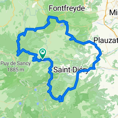
Übersicht
Über diese Route
Puy de Sancy <table class="gal-scaffold" style="width: 300px;"> <tbody> <tr> <td style="padding: 2px 1px; color: rgb(51, 51, 51); font-family: Verdana, sans-serif; border-bottom-style: solid; border-bottom-color: rgb(197, 219, 247); border-left-style: solid; border-left-color: rgb(197, 219, 247); background-color: rgb(230, 242, 230);"> Lunghezza</td> <td style="padding: 2px 1px; color: rgb(51, 51, 51); font-family: Verdana, sans-serif; border-bottom-style: solid; border-bottom-color: rgb(197, 219, 247); border-left-style: solid; border-left-color: rgb(197, 219, 247); background-color: rgb(230, 242, 230);"> 6,06 km</td> </tr> <tr> <td style="padding: 2px 1px; color: rgb(51, 51, 51); font-family: Verdana, sans-serif; border-bottom-style: solid; border-bottom-color: rgb(197, 219, 247); border-left-style: solid; border-left-color: rgb(197, 219, 247); background-color: rgb(230, 242, 230);"> Pendenza media</td> <td style="padding: 2px 1px; color: rgb(51, 51, 51); font-family: Verdana, sans-serif; border-bottom-style: solid; border-bottom-color: rgb(197, 219, 247); border-left-style: solid; border-left-color: rgb(197, 219, 247); background-color: rgb(230, 242, 230);"> 10.9 %</td> </tr> </tbody> </table> <div id="printStats"> <table class="gal-scaffold" style="width: 300px;"> <tbody> <tr> <td style="padding: 2px 1px; color: rgb(51, 51, 51); font-family: Verdana, sans-serif; border-bottom-style: solid; border-bottom-color: rgb(197, 219, 247); border-left-style: solid; border-left-color: rgb(197, 219, 247); background-color: rgb(230, 242, 230);"> Ascesa</td> <td style="padding: 2px 1px; color: rgb(51, 51, 51); font-family: Verdana, sans-serif; border-bottom-style: solid; border-bottom-color: rgb(197, 219, 247); border-left-style: solid; border-left-color: rgb(197, 219, 247); text-align: right; background-color: rgb(230, 242, 230);"> 664 m</td> <td style="padding: 2px 1px; color: rgb(51, 51, 51); font-family: Verdana, sans-serif; border-bottom-style: solid; border-bottom-color: rgb(197, 219, 247); border-left-style: solid; border-left-color: rgb(197, 219, 247); background-color: rgb(230, 242, 230);"> </td> </tr> <tr> <td style="padding: 2px 1px; color: rgb(51, 51, 51); font-family: Verdana, sans-serif; border-bottom-style: solid; border-bottom-color: rgb(197, 219, 247); border-left-style: solid; border-left-color: rgb(197, 219, 247); background-color: rgb(230, 242, 230);"> Pendenza max</td> <td style="padding: 2px 1px; color: rgb(51, 51, 51); font-family: Verdana, sans-serif; border-bottom-style: solid; border-bottom-color: rgb(197, 219, 247); border-left-style: solid; border-left-color: rgb(197, 219, 247); text-align: right; background-color: rgb(230, 242, 230);"> 26.85 %</td> <td style="padding: 2px 1px; color: rgb(51, 51, 51); font-family: Verdana, sans-serif; border-bottom-style: solid; border-bottom-color: rgb(197, 219, 247); border-left-style: solid; border-left-color: rgb(197, 219, 247); text-align: right; background-color: rgb(230, 242, 230);"> km 3.03</td> </tr> <tr> <td style="padding: 2px 1px; color: rgb(51, 51, 51); font-family: Verdana, sans-serif; border-bottom-style: solid; border-bottom-color: rgb(197, 219, 247); border-left-style: solid; border-left-color: rgb(197, 219, 247); background-color: rgb(230, 242, 230);"> "" su 500 m.</td> <td style="padding: 2px 1px; color: rgb(51, 51, 51); font-family: Verdana, sans-serif; border-bottom-style: solid; border-bottom-color: rgb(197, 219, 247); border-left-style: solid; border-left-color: rgb(197, 219, 247); text-align: right; background-color: rgb(230, 242, 230);"> 20.47 %</td> <td style="padding: 2px 1px; color: rgb(51, 51, 51); font-family: Verdana, sans-serif; border-bottom-style: solid; border-bottom-color: rgb(197, 219, 247); border-left-style: solid; border-left-color: rgb(197, 219, 247); text-align: right; background-color: rgb(230, 242, 230);"> km 4.48</td> </tr> <tr> <td style="padding: 2px 1px; color: rgb(51, 51, 51); font-family: Verdana, sans-serif; border-bottom-style: solid; border-bottom-color: rgb(197, 219, 247); border-left-style: solid; border-left-color: rgb(197, 219, 247); background-color: rgb(230, 242, 230);"> "" su 1000 m.</td> <td style="padding: 2px 1px; color: rgb(51, 51, 51); font-family: Verdana, sans-serif; border-bottom-style: solid; border-bottom-color: rgb(197, 219, 247); border-left-style: solid; border-left-color: rgb(197, 219, 247); text-align: right; background-color: rgb(230, 242, 230);"> 17.11 %</td> <td style="padding: 2px 1px; color: rgb(51, 51, 51); font-family: Verdana, sans-serif; border-bottom-style: solid; border-bottom-color: rgb(197, 219, 247); border-left-style: solid; border-left-color: rgb(197, 219, 247); text-align: right; background-color: rgb(230, 242, 230);"> km 3.92</td> </tr> <tr> <td style="padding: 2px 1px; color: rgb(51, 51, 51); font-family: Verdana, sans-serif; border-bottom-style: solid; border-bottom-color: rgb(197, 219, 247); border-left-style: solid; border-left-color: rgb(197, 219, 247); background-color: rgb(230, 242, 230);"> "" su 5000 m.</td> <td style="padding: 2px 1px; color: rgb(51, 51, 51); font-family: Verdana, sans-serif; border-bottom-style: solid; border-bottom-color: rgb(197, 219, 247); border-left-style: solid; border-left-color: rgb(197, 219, 247); text-align: right; background-color: rgb(230, 242, 230);"> 11.85 %</td> <td style="padding: 2px 1px; color: rgb(51, 51, 51); font-family: Verdana, sans-serif; border-bottom-style: solid; border-bottom-color: rgb(197, 219, 247); border-left-style: solid; border-left-color: rgb(197, 219, 247); text-align: right; background-color: rgb(230, 242, 230);"> km 1.05</td> </tr> </tbody> </table> </div> <div> </div>
- -:--
- Dauer
- 6,5 km
- Distanz
- 664 m
- Aufstieg
- 0 m
- Abstieg
- ---
- Ø-Tempo
- ---
- Ø-Tempo

Routenqualität
Wegtypen und Untergründe entlang der Route
Wegtypen
Vielbefahrene Straße
3,3 km
(51 %)
Forst- / Feldweg
2,5 km
(39 %)
Untergründe
Befestigt
2,1 km
(32 %)
Unbefestigt
2,5 km
(39 %)
Schotter
2,2 km
(34 %)
Asphalt
2,1 km
(32 %)
Weiter mit Bikemap
Diese Radroute verwenden, bearbeiten oder herunterladen
Du möchtest Puy de Sancy fahren oder sie für deine eigene Reise anpassen? Folgendes kannst du mit dieser Bikemap-Route machen:
Gratis Funktionen
- Speichere diese Route als Favorit oder in einer Sammlung
- Kopiere & plane deine eigene Version dieser Route
- Synchronisiere deine Route mit Garmin oder Wahoo
Premium-Funktionen
Kostenlose Testversion für 3 Tage oder einmalige Zahlung. Mehr über Bikemap Premium.
- Navigiere diese Route auf iOS & Android
- Exportiere eine GPX / KML-Datei dieser Route
- Erstelle deinen individuellen Ausdruck (Jetzt kostenlos ausprobieren)
- Lade diese Route für die Offline-Navigation herunter
Entdecke weitere Premium-Funktionen.
Bikemap Premium aktivierenVon unserer Community
Le Mont-Dore: Andere beliebte Routen, die hier beginnen
 2019-25 Le-Mont-Dore to Riom-ès-Montagnes
- Distanz
- 60,4 km
- Aufstieg
- 716 m
- Abstieg
- 893 m
- Standort
- Le Mont-Dore, Auvergne-Rhône-Alpes, Frankreich
 Boucle Est Mont Dore
- Distanz
- 93,6 km
- Aufstieg
- 1.610 m
- Abstieg
- 1.612 m
- Standort
- Le Mont-Dore, Auvergne-Rhône-Alpes, Frankreich
 Mont-Dore Trip#3 80km
- Distanz
- 77,6 km
- Aufstieg
- 1.599 m
- Abstieg
- 1.585 m
- Standort
- Le Mont-Dore, Auvergne-Rhône-Alpes, Frankreich
 Mont-Dore Trip#1 60km
- Distanz
- 57 km
- Aufstieg
- 1.158 m
- Abstieg
- 1.134 m
- Standort
- Le Mont-Dore, Auvergne-Rhône-Alpes, Frankreich
 Mont-Dore Trip#2 80km
- Distanz
- 80,9 km
- Aufstieg
- 1.649 m
- Abstieg
- 1.604 m
- Standort
- Le Mont-Dore, Auvergne-Rhône-Alpes, Frankreich
 France 4 - Massif Central 2
- Distanz
- 107,7 km
- Aufstieg
- 1.542 m
- Abstieg
- 1.542 m
- Standort
- Le Mont-Dore, Auvergne-Rhône-Alpes, Frankreich
 Auvergne1
- Distanz
- 45,2 km
- Aufstieg
- 1.443 m
- Abstieg
- 1.448 m
- Standort
- Le Mont-Dore, Auvergne-Rhône-Alpes, Frankreich
 Boucle nord Mont Dore
- Distanz
- 64,1 km
- Aufstieg
- 949 m
- Abstieg
- 948 m
- Standort
- Le Mont-Dore, Auvergne-Rhône-Alpes, Frankreich
In der App öffnen