

Cow Bay Loop
Eine Fahrradroute, die in Dartmouth, Nova Scotia, Kanada beginnt.
Übersicht
Über diese Route
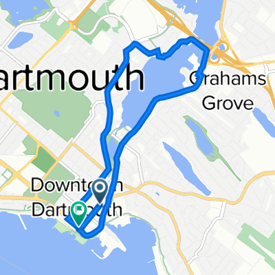
Starting at the Dartmouth-end of the MacDonald Bridge, the route starts through downtown Dartmouth and out towards to Eastern Shore area. It cuts inland after a time and has the rider climb up towards the community of Cow Bay before heading back west through the Forest Hills area and back to downtown Dartmouth. I ended this loop at Alderny Landing (Dartmouth Ferry Terminal), allowing the rider to enjoy downtown Dartmouth, or take the ferry back to Halifax-proper. This route is quite close to being half-drawn-out-climb and half-downhill-coast.
- -:--
- Dauer
- 33,9 km
- Distanz
- 242 m
- Aufstieg
- 268 m
- Abstieg
- ---
- Ø-Tempo
- ---
- Max. Höhe

Routenqualität
Wegtypen und Untergründe entlang der Route
Wegtypen
Vielbefahrene Straße
30,9 km
(91 %)
Zufahrtsstraße
1,4 km
(4 %)
Untergründe
Befestigt
32,6 km
(96 %)
Unbefestigt
0,4 km
(1 %)
Asphalt
17,7 km
(52 %)
Befestigt (undefiniert)
14,9 km
(44 %)
Weiter mit Bikemap
Diese Radroute verwenden, bearbeiten oder herunterladen
Du möchtest Cow Bay Loop fahren oder sie für deine eigene Reise anpassen? Folgendes kannst du mit dieser Bikemap-Route machen:
Gratis Funktionen
- Speichere diese Route als Favorit oder in einer Sammlung
- Kopiere & plane deine eigene Version dieser Route
- Synchronisiere deine Route mit Garmin oder Wahoo
Premium-Funktionen
Kostenlose Testversion für 3 Tage oder einmalige Zahlung. Mehr über Bikemap Premium.
- Navigiere diese Route auf iOS & Android
- Exportiere eine GPX / KML-Datei dieser Route
- Erstelle deinen individuellen Ausdruck (Jetzt kostenlos ausprobieren)
- Lade diese Route für die Offline-Navigation herunter
Entdecke weitere Premium-Funktionen.
Bikemap Premium aktivierenVon unserer Community
Dartmouth: Andere beliebte Routen, die hier beginnen
 Easy ride
- Distanz
- 6,8 km
- Aufstieg
- 36 m
- Abstieg
- 97 m
- Standort
- Dartmouth, Nova Scotia, Kanada
 Round the Basin Ride
- Distanz
- 41,6 km
- Aufstieg
- 266 m
- Abstieg
- 224 m
- Standort
- Dartmouth, Nova Scotia, Kanada
 Shubie to Woodside Loop
- Distanz
- 18,5 km
- Aufstieg
- 165 m
- Abstieg
- 166 m
- Standort
- Dartmouth, Nova Scotia, Kanada
 Citadel Hill Ride
- Distanz
- 9,5 km
- Aufstieg
- 88 m
- Abstieg
- 92 m
- Standort
- Dartmouth, Nova Scotia, Kanada
 Main to Shearwater Flyer Loop
- Distanz
- 28,7 km
- Aufstieg
- 205 m
- Abstieg
- 205 m
- Standort
- Dartmouth, Nova Scotia, Kanada
 Day 1 - Cycle NS East
- Distanz
- 277,6 km
- Aufstieg
- 513 m
- Abstieg
- 522 m
- Standort
- Dartmouth, Nova Scotia, Kanada
 Dartmouth02
- Distanz
- 45,7 km
- Aufstieg
- 291 m
- Abstieg
- 291 m
- Standort
- Dartmouth, Nova Scotia, Kanada
 30 min lake banook
- Distanz
- 6,9 km
- Aufstieg
- 84 m
- Abstieg
- 87 m
- Standort
- Dartmouth, Nova Scotia, Kanada
In der App öffnen