

Camino 2015 04 Gondrecourt-le-Chateau nach Joinville
Eine Fahrradroute, die in Gondrecourt-le-Château, Alsace-Champagne-Ardenne-Lorraine, France beginnt.
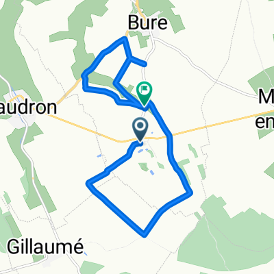
Übersicht
Über diese Route
<table border="0" cellpadding="0" cellspacing="0" style="width:434px;" width="433"> <colgroup> <col span="2" /> <col /> <col /> </colgroup> <tbody> <tr height="37"> <td align="right" height="37" style="height:37px;width:65px;"> </td> <td style="width:65px;"> </td> <td colspan="2" style="width:305px;"> Gondrecourt-le-Chateau</td> </tr> <tr height="21"> <td height="21" style="height:21px;width:65px;"> 4,0</td> <td style="width:65px;"> 4,0</td> <td> Horville-en-Ornois</td> <td> </td> </tr> <tr height="21"> <td height="21" style="height:21px;width:65px;"> 10,0</td> <td style="width:65px;"> 6,0</td> <td> Mandres-en-Barrois</td> <td> </td> </tr> <tr height="21"> <td height="21" style="height:21px;width:65px;"> 15,0</td> <td style="width:65px;"> 5,0</td> <td> Saudron</td> <td> </td> </tr> <tr height="21"> <td height="21" style="height:21px;width:65px;"> 24,0</td> <td style="width:65px;"> 9,0</td> <td> Montreuil-sur-Thonnance</td> <td> </td> </tr> <tr height="21"> <td height="21" style="height:21px;width:65px;"> 30,0</td> <td style="width:65px;"> 6,0</td> <td> Thonnance-lès-Joinville</td> <td> </td> </tr> <tr height="22"> <td height="22" style="height:22px;width:65px;"> 32,0</td> <td style="width:65px;"> 2,0</td> <td> Joinville</td> <td> </td> </tr> </tbody> </table>
Le Val du Roy<br /> 22, rue du Valleroy, 52300 Joinville <br /> Telephone: 0607554367<br /> Mobile: 0607554367 - -:--
- Dauer
- 33,7 km
- Distanz
- 248 m
- Aufstieg
- 349 m
- Abstieg
- ---
- Ø-Tempo
- ---
- Ø-Tempo

Routenqualität
Wegtypen und Untergründe entlang der Route
Wegtypen
Vielbefahrene Straße
23,8 km
(71 %)
Straße
6,4 km
(19 %)
Untergründe
Befestigt
30,4 km
(90 %)
Unbefestigt
0,3 km
(<1 %)
Asphalt
30,4 km
(90 %)
Unbefestigt (undefiniert)
0,3 km
(<1 %)
Undefiniert
3 km
(9 %)
Weiter mit Bikemap
Diese Radroute verwenden, bearbeiten oder herunterladen
Du möchtest Camino 2015 04 Gondrecourt-le-Chateau nach Joinville fahren oder sie für deine eigene Reise anpassen? Folgendes kannst du mit dieser Bikemap-Route machen:
Gratis Funktionen
- Speichere diese Route als Favorit oder in einer Sammlung
- Kopiere & plane deine eigene Version dieser Route
- Synchronisiere deine Route mit Garmin oder Wahoo
Premium-Funktionen
Kostenlose Testversion für 3 Tage oder einmalige Zahlung. Mehr über Bikemap Premium.
- Navigiere diese Route auf iOS & Android
- Exportiere eine GPX / KML-Datei dieser Route
- Erstelle deinen individuellen Ausdruck (Jetzt kostenlos ausprobieren)
- Lade diese Route für die Offline-Navigation herunter
Entdecke weitere Premium-Funktionen.
Bikemap Premium aktivierenVon unserer Community
Gondrecourt-le-Château: Andere beliebte Routen, die hier beginnen
 De Chemin Rural de la Ferme 2, Badonvilliers-Gérauvilliers à Rue du Stade 2, Revigny-sur-Ornain
- Distanz
- 66,9 km
- Aufstieg
- 322 m
- Abstieg
- 559 m
- Standort
- Gondrecourt-le-Château, Alsace-Champagne-Ardenne-Lorraine, Frankreich
 Camino 2015 4b Gendrecourt-le-Chateau nach Joinville
- Distanz
- 35,7 km
- Aufstieg
- 207 m
- Abstieg
- 303 m
- Standort
- Gondrecourt-le-Château, Alsace-Champagne-Ardenne-Lorraine, Frankreich
 Camino 2015 04 Gondrecourt-le-Chateau nach Joinville
- Distanz
- 33,7 km
- Aufstieg
- 248 m
- Abstieg
- 349 m
- Standort
- Gondrecourt-le-Château, Alsace-Champagne-Ardenne-Lorraine, Frankreich
 De D960, Bure à D227, Bure
- Distanz
- 9,3 km
- Aufstieg
- 78 m
- Abstieg
- 108 m
- Standort
- Gondrecourt-le-Château, Alsace-Champagne-Ardenne-Lorraine, Frankreich
 De D960, Bure à D960, Bure
- Distanz
- 12,1 km
- Aufstieg
- 121 m
- Abstieg
- 124 m
- Standort
- Gondrecourt-le-Château, Alsace-Champagne-Ardenne-Lorraine, Frankreich
 De D960, Bure à Bure
- Distanz
- 15,7 km
- Aufstieg
- 213 m
- Abstieg
- 211 m
- Standort
- Gondrecourt-le-Château, Alsace-Champagne-Ardenne-Lorraine, Frankreich
 Jakobsweg_7: Gondrecourt-le-Château - Clairvaux
- Distanz
- 85,3 km
- Aufstieg
- 868 m
- Abstieg
- 976 m
- Standort
- Gondrecourt-le-Château, Alsace-Champagne-Ardenne-Lorraine, Frankreich
 Gondrecourt-le-Château
- Distanz
- 67,5 km
- Aufstieg
- 522 m
- Abstieg
- 522 m
- Standort
- Gondrecourt-le-Château, Alsace-Champagne-Ardenne-Lorraine, Frankreich
In der App öffnen