

Armidale to Point Lookout loop
Eine Fahrradroute, die in Armidale, New South Wales, Australien beginnt.
Übersicht
Über diese Route
This was ridden as a three-day loop from Armidale. Day 1 heads up the hilly Rockvale Rd, then turns off along Chandler Rd. The seal runs out after approx. 7 km. However, on both occasions we have ridden this the gravel road to Wollomobi has been in fairly good condition. After a paved short section on the Waterfall Way and the first few kms along the Kempsey Rd, the road turned to gravel again and continued to be very hilly. The 87 km ride to the Wattle Flat camping area was quite tough due to both large amount of gravel road and the hilly nature of the terrain. However, the Wattle flat camping area is a lovely spot and worth the effort.
On day 2, the route climbs back up the hill to Forest way then continues climbing up to the Little Styx picnic area. This short 23 km section was hard going and took us nearly 3 h! We chose to leave the gear there and make the final push up to Point Lookout unladen. The views there are however worth every bit of the sweat required to get there. After returning to the Little Styx for lunch and to pick up our gear. There was another steep climb to negotiate. The remainder of the dirt road up to the highway was in good condition and we made much faster progress. This road can however get very corrugated by the amount of tourist traffic. The remainder of the day’s ride was far from flat but felt very easy on paved roads along Waterfall Way to Ebor then along the Guyra Rd to the Native Dog creek rest area. This is another lovely camping area. However, when we rode in the midst of the drought there was no water in the creek. A caravan owner saw us looking and kindly gave us a top up, but the larger Biscuit Creek about 200 m down the road did have water. Total distance day 2: ~60 km.
Day 3: We continued along the Guyra road (paved) to Rockvale Rd (approx. 10 km unsealed) and back to Armidale ~80 km in total. This is still hilly but net downhill. The circuit was a delightful ride but rated difficult on account of large amounts of gravel road, very hilly terrain as well as total lack of shops requiring carrying enough food for 3 days of hard work.
Note we have not done this ride since the fires went through in late 2019.
- -:--
- Dauer
- 226,3 km
- Distanz
- 4.225 m
- Aufstieg
- 4.225 m
- Abstieg
- ---
- Ø-Tempo
- 1.558 m
- Max. Höhe

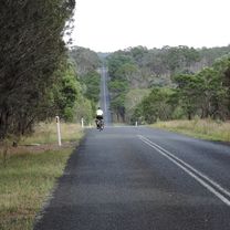
Fotos von der Route


Routenqualität
Wegtypen und Untergründe entlang der Route
Wegtypen
Straße
138,3 km
(61 %)
Vielbefahrene Straße
57,1 km
(25 %)
Untergründe
Befestigt
138 km
(61 %)
Unbefestigt
87,3 km
(39 %)
Asphalt
133,1 km
(59 %)
Unbefestigt (undefiniert)
86,6 km
(38 %)
Weiter mit Bikemap
Diese Radroute verwenden, bearbeiten oder herunterladen
Du möchtest Armidale to Point Lookout loop fahren oder sie für deine eigene Reise anpassen? Folgendes kannst du mit dieser Bikemap-Route machen:
Gratis Funktionen
- Speichere diese Route als Favorit oder in einer Sammlung
- Kopiere & plane deine eigene Version dieser Route
- Teile sie in Etappen ein, um eine mehrtägige Tour zu erstellen
- Synchronisiere deine Route mit Garmin oder Wahoo
Premium-Funktionen
Kostenlose Testversion für 3 Tage oder einmalige Zahlung. Mehr über Bikemap Premium.
- Navigiere diese Route auf iOS & Android
- Exportiere eine GPX / KML-Datei dieser Route
- Erstelle deinen individuellen Ausdruck (Jetzt kostenlos ausprobieren)
- Lade diese Route für die Offline-Navigation herunter
Entdecke weitere Premium-Funktionen.
Bikemap Premium aktivierenVon unserer Community
Armidale: Andere beliebte Routen, die hier beginnen
 Armidale to Uralla via Arding
- Distanz
- 54,5 km
- Aufstieg
- 405 m
- Abstieg
- 396 m
- Standort
- Armidale, New South Wales, Australien
 Flat White
- Distanz
- 19,5 km
- Aufstieg
- 203 m
- Abstieg
- 201 m
- Standort
- Armidale, New South Wales, Australien
 Armidale, Toms Gully, Puddledock loop
- Distanz
- 71,6 km
- Aufstieg
- 607 m
- Abstieg
- 607 m
- Standort
- Armidale, New South Wales, Australien
 Avoiding the Waterfall Way from Armidale
- Distanz
- 92,5 km
- Aufstieg
- 708 m
- Abstieg
- 708 m
- Standort
- Armidale, New South Wales, Australien
 Armidale to Point Lookout loop
- Distanz
- 226,3 km
- Aufstieg
- 4.225 m
- Abstieg
- 4.225 m
- Standort
- Armidale, New South Wales, Australien
 Armidale to Gara river crossing along Herbert Park Rd
- Distanz
- 48,3 km
- Aufstieg
- 516 m
- Abstieg
- 515 m
- Standort
- Armidale, New South Wales, Australien
 Armidale Tourist Information Centre to Dangars Gorge return
- Distanz
- 47 km
- Aufstieg
- 355 m
- Abstieg
- 353 m
- Standort
- Armidale, New South Wales, Australien
 Armidale, Rockvale Rd Chandler Rd loop
- Distanz
- 86,1 km
- Aufstieg
- 772 m
- Abstieg
- 773 m
- Standort
- Armidale, New South Wales, Australien
In der App öffnen