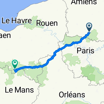
Essone - 80km
Eine Fahrradroute, die in Nogent-sur-Oise, Nord-Pas-de-Calais-Picardie, France beginnt.
Übersicht
Über diese Route
02 novembre 2014
<span style="font-size: 28px; line-height: 1.2em;">79,8km</span> <div class="label" style="margin: 0px; padding: 0px; cursor: pointer; clear: both; color: rgb(153, 153, 153); -webkit-user-select: none; font-size: 1.2rem; white-space: normal; max-width: 80px; line-height: 1.2em;"> Distance</div> <span style="font-size: 28px; line-height: 1.2em;">3:50:44</span> <div class="label" style="margin: 0px; padding: 0px; cursor: pointer; clear: both; color: rgb(153, 153, 153); -webkit-user-select: none; font-size: 1.2rem; white-space: normal; max-width: 80px; line-height: 1.2em;"> Durée de déplacement</div> <span style="font-size: 28px; line-height: 1.2em;">483m</span> <div> <table class="unstyled" style="border-spacing: 0px; padding: 0px; margin: 0px; width: 443px; color: rgb(51, 51, 51); font-family: 'Helvetica Neue', Helvetica, Arial, sans-serif; line-height: 18px;"> <thead> <tr style="border: none; background: none;"> <th style="padding: 2px 0px; border: none; box-shadow: none; vertical-align: top;"> Moy.</th> <th style="padding: 2px 60px 2px 0px; border: none; box-shadow: none; vertical-align: top;"> Max.</th> </tr> </thead> <tbody> <tr style="border: none; background: none;"> <th style="font-weight: 400; padding: 2px 0px; box-shadow: none; border: none; vertical-align: top;"> Vitesse</th> <td style="padding: 2px 0px; border: none; box-shadow: none; vertical-align: top;"> 20,7km/h</td> <td style="padding: 2px 60px 2px 0px; border: none; box-shadow: none; vertical-align: top;"> 56,9km/h</td> </tr> </tbody> <tbody> <tr style="border: none; background: none;"> <th style="font-weight: 400; padding: 2px 0px; box-shadow: none; border: none; vertical-align: top;"> <span class="glossary-link run-version" data-glossary-term="definition-elapsed-time" style="position: relative; border-bottom-width: 1px; border-bottom-style: dotted; border-bottom-color: rgba(0, 0, 0, 0); display: inline-block; -webkit-transition: border 0.1s linear; transition: border 0.1s linear;">Temps écoulé</span></th> <td colspan="2" style="padding: 2px 60px 2px 0px; border: none; box-shadow: none; vertical-align: top;"> 4:16:42</td> </tr> </tbody> </table> </div>
- -:--
- Dauer
- 79,2 km
- Distanz
- 259 m
- Aufstieg
- 237 m
- Abstieg
- ---
- Ø-Tempo
- ---
- Ø-Tempo
Routenqualität
Wegtypen und Untergründe entlang der Route
Wegtypen
Straße
40,8 km
(52 %)
Vielbefahrene Straße
30,9 km
(39 %)
Untergründe
Befestigt
8,3 km
(10 %)
Unbefestigt
1,8 km
(2 %)
Asphalt
8,3 km
(10 %)
Natürlicher Untergrund
1,5 km
(2 %)
Weiter mit Bikemap
Diese Radroute verwenden, bearbeiten oder herunterladen
Du möchtest Essone - 80km fahren oder sie für deine eigene Reise anpassen? Folgendes kannst du mit dieser Bikemap-Route machen:
Gratis Funktionen
- Speichere diese Route als Favorit oder in einer Sammlung
- Kopiere & plane deine eigene Version dieser Route
- Synchronisiere deine Route mit Garmin oder Wahoo
Premium-Funktionen
Kostenlose Testversion für 3 Tage oder einmalige Zahlung. Mehr über Bikemap Premium.
- Navigiere diese Route auf iOS & Android
- Exportiere eine GPX / KML-Datei dieser Route
- Erstelle deinen individuellen Ausdruck (Jetzt kostenlos ausprobieren)
- Lade diese Route für die Offline-Navigation herunter
Entdecke weitere Premium-Funktionen.
Bikemap Premium aktivierenVon unserer Community
Nogent-sur-Oise: Andere beliebte Routen, die hier beginnen
- Recovered Route
- Distanz
- 11,9 km
- Aufstieg
- 145 m
- Abstieg
- 115 m
- Standort
- Nogent-sur-Oise, Nord-Pas-de-Calais-Picardie, Frankreich
- Creil - St Max
- Distanz
- 3,9 km
- Aufstieg
- 42 m
- Abstieg
- 19 m
- Standort
- Nogent-sur-Oise, Nord-Pas-de-Calais-Picardie, Frankreich
- Tour de France Variant Etape 21 : Creil - Paris Champs Elysées
- Distanz
- 115,4 km
- Aufstieg
- 370 m
- Abstieg
- 344 m
- Standort
- Nogent-sur-Oise, Nord-Pas-de-Calais-Picardie, Frankreich
- Creil - Pierrefonds
- Distanz
- 80,8 km
- Aufstieg
- 337 m
- Abstieg
- 264 m
- Standort
- Nogent-sur-Oise, Nord-Pas-de-Calais-Picardie, Frankreich
- Essone - 80km
- Distanz
- 79,2 km
- Aufstieg
- 259 m
- Abstieg
- 237 m
- Standort
- Nogent-sur-Oise, Nord-Pas-de-Calais-Picardie, Frankreich
- AVC Ride #4 :: Creil - Conflans
- Distanz
- 62,2 km
- Aufstieg
- 130 m
- Abstieg
- 134 m
- Standort
- Nogent-sur-Oise, Nord-Pas-de-Calais-Picardie, Frankreich
- Creil-Fécamp
- Distanz
- 300 km
- Aufstieg
- 623 m
- Abstieg
- 568 m
- Standort
- Nogent-sur-Oise, Nord-Pas-de-Calais-Picardie, Frankreich
- Creil-Havre
- Distanz
- 285,1 km
- Aufstieg
- 1.935 m
- Abstieg
- 1.956 m
- Standort
- Nogent-sur-Oise, Nord-Pas-de-Calais-Picardie, Frankreich
In der App öffnen