

New Addington Loop Through Warlingham and Woldingham
Eine Fahrradroute, die in West Wickham, England, Vereinigtes Königreich beginnt.
Übersicht
Über diese Route
Eine weitere Route, die eine Mischung aus Straßen- und Geländefahrten ist. Wahrscheinlich auf einem Hybrid möglich, aber ich würde definitiv ein Mountainbike empfehlen.
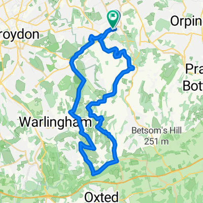
Starten Sie in New Addington und fahren Sie die Lodge Lane hinunter (Sie können die Straße nehmen, aber wir nehmen normalerweise den Weg, der vom großen Kreisverkehr an der linken Seite der Straßenbahnschienen nach unten läuft). Auf der Straße fahren Sie zurück bis zum oberen Ende der Court Wood Lane in Forestdale und fahren dann durch den Wald bis zum Eingang des Old Farleigh Golf Clubs (was auch eine spaßige Abfahrt für sich ist). Biegen Sie auf die Old Farleigh Road ab und nehmen Sie dann den Weg links, der direkt zum The Harrow führt. Am The Harrow biegen Sie links auf die Straße ab und bleiben auf der Straße, bis Sie zum Wald kommen, der hinter dem Friedhof vorbeiführt. Am Ende kreuzen Sie die Limpsfield Road und fahren den Flint-Weg neben dem Waddon Golfplatz hinunter (viel Spaß beim Vollgasfahren, besonders nachts), vorbei am Clubhaus und hinauf zur Straße.
Nachdem Sie den Weg zur Auffahrt der Mädchenschule erreicht haben (ich glaube, es ist Teil der Radroute 21), beginnt ein langer, langsamer Asphaltanstieg bis zum Fuß von Great Church Wood. Die Fahrt durch Great Church Wood macht Spaß, wird aber sowohl Ihre Lunge als auch Ihre Beine fordern (als alternative Strecke fahren Sie weiter die Auffahrt hinauf bis zum Fuß von Ganger's Hill und arbeiten sich durch den dortigen Wald hoch, was Ihnen die gleiche Trainingsintensität bringt).
Oben auf Ganger's Hill sind Sie wieder auf der Straße Richtung Botley Hill Farm (ein guter Ort für ein wohlverdientes Bier, bevor Sie die Abfahrt nach Hause antreten). Nach Botley Hill Farm können Sie den Radweg hinunterfahren, bis Sie bei Beech Farm Road auf die Straße abbiegen und dieser folgen, vorbei am White Bear in Richtung Park Road und dem Feld parallel zur Skid Hill Lane, das Sie zurück nach New Addington bringt.
Wenn Sie eine etwas längere Tour möchten, können Sie den Radweg auf der Croydon Road/Limpsfield Road weiterfahren, den Weg rechts hinunter zur Ledgers Road nehmen, auf der Straße zur Church Lane, durch Holt Wood auf der unbefestigten Straße und dann die High Hill Road runter (und wieder hoch), die ebenfalls unbefestigt ist, bevor Sie die Route am White Bear wieder aufnehmen.
- -:--
- Dauer
- 27,5 km
- Distanz
- 283 m
- Aufstieg
- 283 m
- Abstieg
- ---
- Ø-Tempo
- ---
- Max. Höhe
Routenqualität
Wegtypen und Untergründe entlang der Route
Wegtypen
Straße
8 km
(29 %)
Ruhige Straße
5,8 km
(21 %)
Untergründe
Befestigt
7,7 km
(28 %)
Unbefestigt
5,2 km
(19 %)
Asphalt
6,6 km
(24 %)
Natürlicher Untergrund
2,5 km
(9 %)
Weiter mit Bikemap
Diese Radroute verwenden, bearbeiten oder herunterladen
Du möchtest New Addington Loop Through Warlingham and Woldingham fahren oder sie für deine eigene Reise anpassen? Folgendes kannst du mit dieser Bikemap-Route machen:
Gratis Funktionen
- Speichere diese Route als Favorit oder in einer Sammlung
- Kopiere & plane deine eigene Version dieser Route
- Synchronisiere deine Route mit Garmin oder Wahoo
Premium-Funktionen
Kostenlose Testversion für 3 Tage oder einmalige Zahlung. Mehr über Bikemap Premium.
- Navigiere diese Route auf iOS & Android
- Exportiere eine GPX / KML-Datei dieser Route
- Erstelle deinen individuellen Ausdruck (Jetzt kostenlos ausprobieren)
- Lade diese Route für die Offline-Navigation herunter
Entdecke weitere Premium-Funktionen.
Bikemap Premium aktivierenVon unserer Community
West Wickham: Andere beliebte Routen, die hier beginnen
 test
test- Distanz
- 38,4 km
- Aufstieg
- 401 m
- Abstieg
- 401 m
- Standort
- West Wickham, England, Vereinigtes Königreich
 hayes hayes plan
- Distanz
- 31,1 km
- Aufstieg
- 350 m
- Abstieg
- 352 m
- Standort
- West Wickham, England, Vereinigtes Königreich
 Botley Hill
- Distanz
- 30,7 km
- Aufstieg
- 402 m
- Abstieg
- 400 m
- Standort
- West Wickham, England, Vereinigtes Königreich
 New Addington Loop Past Botley Hill and Through Biggin Hill
- Distanz
- 24,5 km
- Aufstieg
- 257 m
- Abstieg
- 247 m
- Standort
- West Wickham, England, Vereinigtes Königreich
 TOUR OF DARWIN COUNTY
- Distanz
- 31 km
- Aufstieg
- 308 m
- Abstieg
- 309 m
- Standort
- West Wickham, England, Vereinigtes Königreich
 ahs sponsored walk
- Distanz
- 14,4 km
- Aufstieg
- 205 m
- Abstieg
- 203 m
- Standort
- West Wickham, England, Vereinigtes Königreich
 LullingStone country park
- Distanz
- 39,8 km
- Aufstieg
- 435 m
- Abstieg
- 437 m
- Standort
- West Wickham, England, Vereinigtes Königreich
 Hayes station 37km
- Distanz
- 37,2 km
- Aufstieg
- 412 m
- Abstieg
- 415 m
- Standort
- West Wickham, England, Vereinigtes Königreich
In der App öffnen