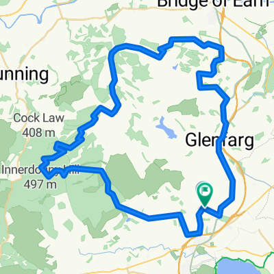
- 28,1 km
- 307 m
- 119 m
- Milnathort, Schottland, Vereinigtes Königreich
The KCC Fixie Time Trial
Eine Fahrradroute, die in Milnathort, Schottland, Vereinigtes Königreich beginnt.
Übersicht
Über diese Route
Der Start liegt ein paar hundert Yards westlich des Mini-Kreisverkehrs im Zentrum von Milnathort. Fahren Sie 7,4 Meilen auf der A91 nach Westen. Biegen Sie rechts ab und dann wieder rechts um die „Verkehrsinseln“ (Marshal) zurück in Richtung Milnathort auf der A91. Biegen Sie bei 14,1 Meilen scharf links an der Kreuzung direkt nach der schwarz-weißen Brücke (Schild Stronachie 4, Marshal) ab. Fahren Sie den kurzen Anstieg hinauf und biegen Sie wieder rechts ab (Schild Stronachie, Marshal). Fahren Sie an der Kreuzung (15,1 Meilen, Marshal) geradeaus und treten Sie den Craigow Hill-Anstieg für weitere 2,4 Meilen bis zum Ziel an. Fahren Sie zweihundert Yards weiter zur Abzweigung zum Wald, um wieder zu Atem zu kommen, bevor Sie nach Milnathort zurückfahren.
- -:--
- Dauer
- 28,1 km
- Distanz
- 307 m
- Aufstieg
- 119 m
- Abstieg
- ---
- Ø-Tempo
- ---
- Max. Höhe
Erstellt vor 10 Jahren
Routenqualität
Wegtypen und Untergründe entlang der Route
Wegtypen
Straße
3,4 km
(12 %)
Zufahrtsstraße
2,3 km
(8 %)
Untergründe
Befestigt
9,6 km
(34 %)
Asphalt
9,6 km
(34 %)
Undefiniert
18,6 km
(66 %)
Weiter mit Bikemap
Diese Radroute verwenden, bearbeiten oder herunterladen
Du möchtest The KCC Fixie Time Trial fahren oder sie für deine eigene Reise anpassen? Folgendes kannst du mit dieser Bikemap-Route machen:
Gratis Funktionen
- Speichere diese Route als Favorit oder in einer Sammlung
- Kopiere & plane deine eigene Version dieser Route
- Synchronisiere deine Route mit Garmin oder Wahoo
Premium-Funktionen
Kostenlose Testversion für 3 Tage oder einmalige Zahlung. Mehr über Bikemap Premium.
- Navigiere diese Route auf iOS & Android
- Exportiere eine GPX / KML-Datei dieser Route
- Erstelle deinen individuellen Ausdruck (Jetzt kostenlos ausprobieren)
- Lade diese Route für die Offline-Navigation herunter
Entdecke weitere Premium-Funktionen.
Bikemap Premium aktivierenVon unserer Community
Milnathort: Andere beliebte Routen, die hier beginnen
- The KCC Fixie Time Trial
- Water of May Dron Burn
- 48,3 km
- 864 m
- 868 m
- Milnathort, Schottland, Vereinigtes Königreich
- West Lomond
- 9 km
- 375 m
- 375 m
- Milnathort, Schottland, Vereinigtes Königreich
- Loch Leven Heritage Trail to New Skinner's Close 45
- 51,5 km
- 509 m
- 543 m
- Milnathort, Schottland, Vereinigtes Königreich
- Leg 3 Day 2
- 56,7 km
- 443 m
- 479 m
- Milnathort, Schottland, Vereinigtes Königreich
- Gallowhill Road to Kinloch Street 150
- 80,9 km
- 589 m
- 708 m
- Milnathort, Schottland, Vereinigtes Königreich
- Loch Leven Circuit (s.Leven Larder)
- 21,5 km
- 72 m
- 74 m
- Milnathort, Schottland, Vereinigtes Königreich
- Dunfermline down and up
- 62,2 km
- 394 m
- 395 m
- Milnathort, Schottland, Vereinigtes Königreich
In der App öffnen


