new longest ride post surgery
- 60 km
- 385 m
- 354 m
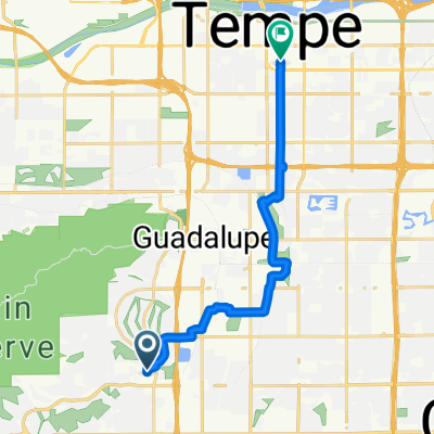
- Guadalupe, Arizona, Vereinigte Staaten
Eine Fahrradroute, die in Guadalupe, Arizona, Vereinigte Staaten beginnt.
Übersicht
Vielfältige Fahrt durch die Stadt mit einigen längeren Straßen (weniger Stopps). Fast alle Straßen haben Radwege, und die Seitenstreifen sind auf der Pecos breit (die manchmal stark befahren sein können). Die Überquerung der Autobahn auf der Guadalupe erfolgt über eine Rampenlose Überführung, während die Überquerung von Chandler Blvd der typischen I-10 Auffahrt/Abfahrt entspricht. Wenn der Hügel auf der Chandler Blvd nicht zu Ihrem Geschmack passt, ist die Umleitung über den Desert Foothills Pkwy eine nette Abwechslung. Sie werden wahrscheinlich viele Radfahrer auf Teilen dieser Strecke sehen, und es gibt zahlreiche Haltepunkte für Essen, Wasser usw. Die Start-/Stopppunkte befinden sich im Performance Bike Parkplatz. Wenn Sie die Strecke verkürzen möchten, sollten Sie Warner verwenden (Elliot Rd kann starker Verkehr sein).
Erstellt vor 10 Jahren
Weiter mit Bikemap
Du möchtest Ahwatukee Pecos Loop fahren oder sie für deine eigene Reise anpassen? Folgendes kannst du mit dieser Bikemap-Route machen:
Kostenlose Testversion für 3 Tage oder einmalige Zahlung. Mehr über Bikemap Premium.
Entdecke weitere Premium-Funktionen.
Bikemap Premium aktivierenVon unserer Community
In der App öffnen