

Sun City Bike Club Hard Ride 3 Out and Back to Beaverdam, Arizona
Eine Fahrradroute, die in Mesquite, Nevada, Vereinigte Staaten beginnt.
Übersicht
Über diese Route
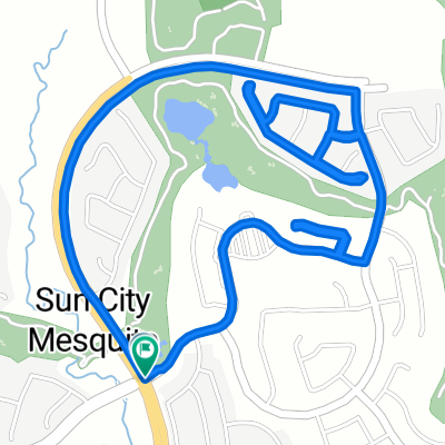
This rides starts at the corner of Flat Top Mesa Drive and Falcon Ridge Parkway; continues generally South through the two roundabouts, then jogs right off the second roundabout onto West Mesquite Boulevard; the ride continues East on West Mesquite Boulevard to a left (North) turn onto South Sandhill Boulevard; riders continue on South Sandhill Boulevard a short distance to a right (North) turn onto East Old Mill Road; almost immediately, riders take a left turn into the shopping center parking lot and continue riding around the back of the Smith's grocery store to Hillside Drive; turning right onto Hillside Drive (old Highway 91), riders now ride up a steep hill into Arizona and continue to follow Highway 91 all the way into Beaverdam, including a long but manageable climb about half way from Mesquite to Beaverdam, flats, then a fairly steep downhill run into Beaverdam; the riders turn around at the Beaverdam Store (the "Dam Store" for short); then reverse their course through ups, downs and flats back into Mesquite, continuing to the Smith's parking lot, where the riders again ride behind the store to East Old Mill Road; the ride continues by turning right onto East Old Mill Road and riding to the intersection of West Mesquite Boulevard, where the riders turn right; West Mesquite Boulevard is ridden West, then jogging right through both roundabouts onto Falcon Ridge Parkway; the ride ends by following Falcon Ridge Parkway up hill back to the intersection of Flat Top Mesa Drive and Falcon Ridge Parkway. Total Ride Distance: 31.6 Miles.
A grreat addition to this ride is to continue following old Highway 91 to the Utah border (an additional 7 miles from Beaverdam), or even further up Utah Hill turning around perpendicular to the fire tower (an additional 16 miles from Beaverdam). The ride to the Utah border is a pretty stiff climb; from there to the fire tower the climbing gets down right serious (but manageable). Notes: 1. If you open the route in Google Roadmap or Google Hybrid (pulled down from the "Relief Map" tab) you will get a more up-to-date view of the roads and paths. Some of the other maps are dated. 2. There are three cattle guards (grates) that cross the roadway on this route. 3. The pavement for the last mile or so heading into Beaverdam is terrible, so use caution. 4. This mapping program tends to under-compute the total ride mileage by roughly 10%, based on mileage for this ride when it has been actually ridden.- -:--
- Dauer
- 50,9 km
- Distanz
- 305 m
- Aufstieg
- 306 m
- Abstieg
- ---
- Ø-Tempo
- ---
- Max. Höhe
Routenqualität
Wegtypen und Untergründe entlang der Route
Wegtypen
Straße
6,6 km
(13 %)
Ruhige Straße
3,1 km
(6 %)
Untergründe
Befestigt
44,3 km
(87 %)
Unbefestigt
1 km
(2 %)
Asphalt
44,3 km
(87 %)
Natürlicher Untergrund
1 km
(2 %)
Undefiniert
5,6 km
(11 %)
Weiter mit Bikemap
Diese Radroute verwenden, bearbeiten oder herunterladen
Du möchtest Sun City Bike Club Hard Ride 3 Out and Back to Beaverdam, Arizona fahren oder sie für deine eigene Reise anpassen? Folgendes kannst du mit dieser Bikemap-Route machen:
Gratis Funktionen
- Speichere diese Route als Favorit oder in einer Sammlung
- Kopiere & plane deine eigene Version dieser Route
- Synchronisiere deine Route mit Garmin oder Wahoo
Premium-Funktionen
Kostenlose Testversion für 3 Tage oder einmalige Zahlung. Mehr über Bikemap Premium.
- Navigiere diese Route auf iOS & Android
- Exportiere eine GPX / KML-Datei dieser Route
- Erstelle deinen individuellen Ausdruck (Jetzt kostenlos ausprobieren)
- Lade diese Route für die Offline-Navigation herunter
Entdecke weitere Premium-Funktionen.
Bikemap Premium aktivierenVon unserer Community
Mesquite: Andere beliebte Routen, die hier beginnen
 Mesquite half loop.
- Distanz
- 17,6 km
- Aufstieg
- 253 m
- Abstieg
- 256 m
- Standort
- Mesquite, Nevada, Vereinigte Staaten
 Sun City Bike Club Easy Ride 3 (Tannery Cove)
- Distanz
- 4,5 km
- Aufstieg
- 114 m
- Abstieg
- 114 m
- Standort
- Mesquite, Nevada, Vereinigte Staaten
 Settlers Way, Mesquite to 1350 Flat Top Mesa Dr, Mesquite
- Distanz
- 15,1 km
- Aufstieg
- 232 m
- Abstieg
- 194 m
- Standort
- Mesquite, Nevada, Vereinigte Staaten
 Cycle-a-thon for Cancer
- Distanz
- 16,3 km
- Aufstieg
- 132 m
- Abstieg
- 162 m
- Standort
- Mesquite, Nevada, Vereinigte Staaten
 1350 Flat Top Mesa Dr, Mesquite to 1173 Clouds Rest Pt, Mesquite
- Distanz
- 0,9 km
- Aufstieg
- 21 m
- Abstieg
- 32 m
- Standort
- Mesquite, Nevada, Vereinigte Staaten
 Sun City Bike Club Easy Ride 4 (Wagon Wheel, Overland Trail and Frontier Pass Neighborhoods)
- Distanz
- 5 km
- Aufstieg
- 91 m
- Abstieg
- 89 m
- Standort
- Mesquite, Nevada, Vereinigte Staaten
 Mesquite, NV - Dolan Springs, NV
- Distanz
- 238,4 km
- Aufstieg
- 1.600 m
- Abstieg
- 1.046 m
- Standort
- Mesquite, Nevada, Vereinigte Staaten
 Sun City Bike Club Easy Ride 2 Out and Back Around Mesquite (With Some Climbs)
- Distanz
- 20,1 km
- Aufstieg
- 81 m
- Abstieg
- 82 m
- Standort
- Mesquite, Nevada, Vereinigte Staaten
In der App öffnen