
High Wycombe: Modified HWCC 50 PR Route
Eine Fahrradroute, die in High Wycombe, England, United Kingdom beginnt.
Übersicht
Über diese Route
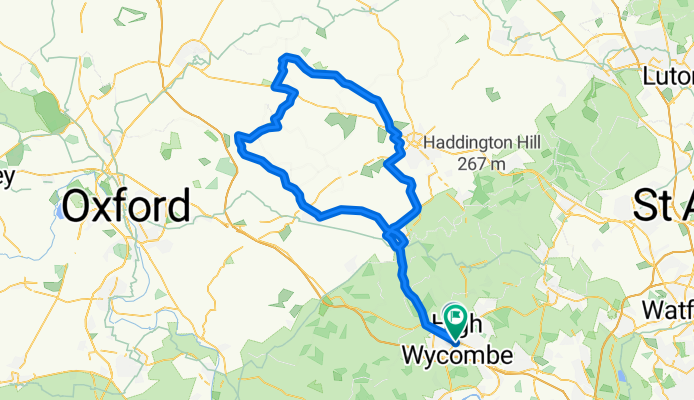
This is really a gem for High Wycombe. I've had heaps of trouble finding a nice flat route to do some long endurance work on. I've now come to the conclusion that this is probably the best. There are a few hills, but they're either short, not very steep or you'll have a strong tailwind to push you up them.
I've made one change to the route I found on High Wycombe Cycle Club's website, and that's to extend the cycle by running into Edgcott instead of going south soon after Quainton. Adds about 10km on to get me close to 100km. Roads are average and no traffic filters either, little bit windy both times I've ridden there though.
Only complaint about the route is the A4010 to Princes Risborough. The drivers are a little bit dangerous sometimes and the road quality is really poor at some stages, forcing you to ride in the middle of the road at some sections. Best idea is to go during quiet traffic times or adding going through Chesnut Way>Chinor Road and adding a few km and two hills at Stokenchurch on the way there and Aston Hill on the way back.
Takes around 3 hours to complete.
- -:--
- Dauer
- 98,6 km
- Distanz
- 326 m
- Aufstieg
- 329 m
- Abstieg
- ---
- Ø-Tempo
- ---
- Ø-Tempo

Weiter mit Bikemap
Diese Radroute verwenden, bearbeiten oder herunterladen
Du möchtest High Wycombe: Modified HWCC 50 PR Route fahren oder sie für deine eigene Reise anpassen? Folgendes kannst du mit dieser Bikemap-Route machen:
Gratis Funktionen
- Speichere diese Route als Favorit oder in einer Sammlung
- Kopiere & plane deine eigene Version dieser Route
- Synchronisiere deine Route mit Garmin oder Wahoo
Premium-Funktionen
Kostenlose Testversion für 3 Tage oder einmalige Zahlung. Mehr über Bikemap Premium.
- Navigiere diese Route auf iOS & Android
- Exportiere eine GPX / KML-Datei dieser Route
- Erstelle deinen individuellen Ausdruck (Jetzt kostenlos ausprobieren)
- Lade diese Route für die Offline-Navigation herunter
Entdecke weitere Premium-Funktionen.
Bikemap Premium aktivierenVon unserer Community
High Wycombe: Andere beliebte Routen, die hier beginnen
 Lady Verney Close 18 to Lady Verney Close 19
- Distanz
- 19,8 km
- Aufstieg
- 68 m
- Abstieg
- 161 m
- Standort
- High Wycombe, England, Vereinigtes Königreich
 HW40k
HW40k- Distanz
- 40,6 km
- Aufstieg
- 350 m
- Abstieg
- 350 m
- Standort
- High Wycombe, England, Vereinigtes Königreich
 Route from Wycombe to Wycombe near river
- Distanz
- 62,9 km
- Aufstieg
- 639 m
- Abstieg
- 641 m
- Standort
- High Wycombe, England, Vereinigtes Königreich
 West Wycombe 7/4/18
- Distanz
- 16,1 km
- Aufstieg
- 1.522 m
- Abstieg
- 1.534 m
- Standort
- High Wycombe, England, Vereinigtes Königreich
 Harriss' WCC Lockdown Route
- Distanz
- 100,9 km
- Aufstieg
- 610 m
- Abstieg
- 616 m
- Standort
- High Wycombe, England, Vereinigtes Königreich
 Sunday Spin
- Distanz
- 32,5 km
- Aufstieg
- 291 m
- Abstieg
- 291 m
- Standort
- High Wycombe, England, Vereinigtes Königreich
 ride through High Wycombe
- Distanz
- 24 km
- Aufstieg
- 233 m
- Abstieg
- 233 m
- Standort
- High Wycombe, England, Vereinigtes Königreich
 Koti HW Bike Route
- Distanz
- 24,6 km
- Aufstieg
- 233 m
- Abstieg
- 233 m
- Standort
- High Wycombe, England, Vereinigtes Königreich
In der App öffnen