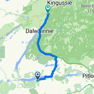
Loch Rannoch to Invernahavon
- 59,7 km
- 614 m
- 587 m
- Kingussie, Schottland, Vereinigtes Königreich
Eine Fahrradroute, die in Kingussie, Schottland, Vereinigtes Königreich beginnt.
Übersicht
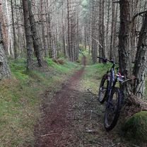
Dies ist eine ernsthafte Route von 53 km / 33 Meilen, die in ein abgelegenes Tal führt. Geeignet für Mountainbikes. Einige Abschnitte sind auf Teer, aber lange Abschnitte verlaufen auf rauen Land Rover-Tracks und erfordern an einem Punkt das Überqueren eines Flusses. Planen Sie 5 Stunden ein. Amtlichekartenblätter 35 - Kingussie und Monadliath Mountains, 42 - Glen Garry und Loch Rannoch. Erfrischungen: Cafés und Bars in Kingussie. Starten Sie im Stadtzentrum von Kingussie und nehmen Sie die ruhige Nebenstraße B970, die an den Ruthven Barracks vorbei führt. Nach eineinhalb Meilen nehmen Sie den grasbewachsenen Land-Rover-Track, der rechts durch ein Tor abzweigt. Folgen Sie diesem Weg durch Moorland und Bäume entlang der Westseite des Flusses Tromie, bis Sie das Haus des Aufsehers des Glen Tromie Lodge erreichen. Überqueren Sie hier den Fluss über die Brücke und biegen Sie rechts auf den Land Rover-Trail ab, der auf die Ostseite des Tromie führt. Der Weg führt dann durch einen Abschnitt von Bäumen, vorbei an der Lynaberack Lodge, wo die Oberfläche asphaltierte und dann den Fluss über eine Brücke überquert. Folgen Sie immer dem Hauptweg und ignorieren Sie alle Abzweigungen nach links oder rechts. Wenn die Route den Tromie Damm erreicht, endet die asphaltierte Straße und der Weg wird zu einem gut erhaltenen Land Rover-Weg. Passieren Sie Loch an t-Seilach und die Gaick Lodge, wo der Weg rauer wird. Kurz nach der Lodge an einer Gabelung abbiegen, um den Fluss erneut an einer Furt zu überqueren. Hier muss Vorsicht walten, und wenn der Wasserstand zu hoch ist, endet die Route hier. Wenn das Wasser passierbar ist, ist es besser, hindurch zu waten, als zu versuchen, zu radeln. Nachdem Sie Loch Bhrodainn rechts passiert haben, wird der Weg steiler und erreicht Loch an Duin, obwohl diese Route dort endet, wo der Land Rover-Weg endet, bevor sie das Loch ganz erreicht. Nach einer wohlverdienten Pause kehren Sie um und genießen die viel einfachere Rückfahrt durch Glen Tromie auf der Hinroute. Es ist auch möglich, die Route zu verlängern, wenn es nicht zu viel kürzliche Niederschläge gegeben hat, über einen Weg auf der Ostseite von Loch Duin. Dies führt zu einem anderen Land Rover-Weg, der letztendlich zur Dalnacardoch Lodge führt. Von hier aus ist es möglich, sich der Sustrans Route 7 anzuschließen, die nach Norden führt und zurück nach Newtonmore und Kingussie.
Erstellt vor 10 Jahren
Routenqualität
Forst- / Feldweg
10,3 km
(39 %)
Ruhige Straße
10,1 km
(38 %)
Befestigt
10,9 km
(41 %)
Unbefestigt
12,7 km
(48 %)
Asphalt
10,6 km
(40 %)
Unbefestigt (undefiniert)
6,4 km
(24 %)
Highlights der Route

Bridge at Tromie Lodge

Bridge over Tromie

Gaick Lodge
Weiter mit Bikemap
Du möchtest Kingussie, Glen Tromie and Gaick fahren oder sie für deine eigene Reise anpassen? Folgendes kannst du mit dieser Bikemap-Route machen:
Kostenlose Testversion für 3 Tage oder einmalige Zahlung. Mehr über Bikemap Premium.
Entdecke weitere Premium-Funktionen.
Bikemap Premium aktivierenVon unserer Community
In der App öffnen