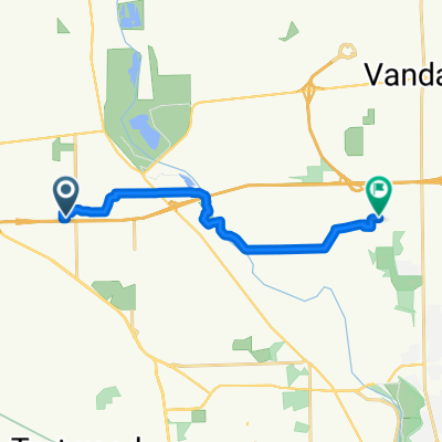
Over the River 'N through the 'Wood 2016
Eine Fahrradroute, die in Englewood, Ohio, Vereinigte Staaten beginnt.
Übersicht
Über diese Route
Die Route beginnt im Centennial Park, Englewood OH und führt über die Radroute nach Süden durch ein Wohngebiet zur Wenger Road. Die Fahrer fahren nach Westen zur Crestway, dann nach Süden zur Kimmel. Folgen Sie der Kimmel nach Westen zur Wastler, über Diamond Mill zur East Upper Salem zur Wellbaum und nordwärts zur Wengerlawn. Als Nächstes fahren die Fahrer nach Westen auf der Wengerlawn zur Brookville-Phillipsburg Road, wo sie nach Norden zur East Main in Phillipsburg fahren. (Hinweis: Der erste Pausenbereich befindet sich im Brookville Community Park, kurz bevor die E. Main erreicht wird.) Als Nächstes fahren die Fahrer nach Osten auf der Phillipsburg-Union zur Pansing, dann nach Norden zur Frederick-Garland, nach Osten über die SR48 und den Still Water River zur Ballinger, die zu Old Springfield West wird und schließlich bei der Überquerung der SR48 zu Phillipsburg-Union wird. Fahren Sie weiter nach Westen zur Putnam, nach Süden zur Sweet Potato Ridge, nach Westen zur Barnes und nach Süden zur National Road. Von hier aus fahren die Fahrer nach Osten und schließen sich der Radroute auf der Hoke Rd wieder an und kehren zum Centennial Park zurück.
- -:--
- Dauer
- 48,1 km
- Distanz
- 137 m
- Aufstieg
- 136 m
- Abstieg
- ---
- Ø-Tempo
- ---
- Max. Höhe
Routenqualität
Wegtypen und Untergründe entlang der Route
Wegtypen
Straße
23,1 km
(48 %)
Ruhige Straße
20,2 km
(42 %)
Untergründe
Befestigt
2,9 km
(6 %)
Asphalt
2,9 km
(6 %)
Undefiniert
45,2 km
(94 %)
Weiter mit Bikemap
Diese Radroute verwenden, bearbeiten oder herunterladen
Du möchtest Over the River 'N through the 'Wood 2016 fahren oder sie für deine eigene Reise anpassen? Folgendes kannst du mit dieser Bikemap-Route machen:
Gratis Funktionen
- Speichere diese Route als Favorit oder in einer Sammlung
- Kopiere & plane deine eigene Version dieser Route
- Synchronisiere deine Route mit Garmin oder Wahoo
Premium-Funktionen
Kostenlose Testversion für 3 Tage oder einmalige Zahlung. Mehr über Bikemap Premium.
- Navigiere diese Route auf iOS & Android
- Exportiere eine GPX / KML-Datei dieser Route
- Erstelle deinen individuellen Ausdruck (Jetzt kostenlos ausprobieren)
- Lade diese Route für die Offline-Navigation herunter
Entdecke weitere Premium-Funktionen.
Bikemap Premium aktivierenVon unserer Community
Englewood: Andere beliebte Routen, die hier beginnen
 1232 Sunset Dr, Englewood to 3462 Garianne Dr, Dayton
- Distanz
- 11,5 km
- Aufstieg
- 102 m
- Abstieg
- 101 m
- Standort
- Englewood, Ohio, Vereinigte Staaten
 Kinsey Road 7119, Englewood to Kinsey Road 7119, Englewood
- Distanz
- 8,8 km
- Aufstieg
- 21 m
- Abstieg
- 26 m
- Standort
- Englewood, Ohio, Vereinigte Staaten
 549–585 E Wenger Rd, Englewood to 549–585 E Wenger Rd, Englewood
- Distanz
- 16,3 km
- Aufstieg
- 238 m
- Abstieg
- 247 m
- Standort
- Englewood, Ohio, Vereinigte Staaten
 Over the River 'N through the 'Wood 2016
- Distanz
- 48,1 km
- Aufstieg
- 137 m
- Abstieg
- 136 m
- Standort
- Englewood, Ohio, Vereinigte Staaten
 Moderate route in Vandalia
- Distanz
- 38,4 km
- Aufstieg
- 272 m
- Abstieg
- 217 m
- Standort
- Englewood, Ohio, Vereinigte Staaten
 Kinsey Road 7119, Englewood to Kinsey Road 7119, Englewood
- Distanz
- 2,6 km
- Aufstieg
- 22 m
- Abstieg
- 21 m
- Standort
- Englewood, Ohio, Vereinigte Staaten
 1236 Sunset Dr, Englewood to 3462 Garianne Dr, Dayton
- Distanz
- 11,5 km
- Aufstieg
- 100 m
- Abstieg
- 96 m
- Standort
- Englewood, Ohio, Vereinigte Staaten
 Overla Boulevard 621, Englewood to Browning Avenue 790, Englewood
- Distanz
- 9,5 km
- Aufstieg
- 0 m
- Abstieg
- 3 m
- Standort
- Englewood, Ohio, Vereinigte Staaten
In der App öffnen

