- 35 km
- 969 m
- 1.041 m
- La Chaux-de-Fonds, Kanton Neuenburg, Schweiz
La Chaux-de-Fonds towards Lake Neuchatel and back
Eine Fahrradroute, die in La Chaux-de-Fonds, Kanton Neuenburg, Schweiz beginnt.
Übersicht
Über diese Route
Sweet two hour ride with a spectacular descent down La Tournee, followed by a traverse across the Val de Ruz. The climb from Chezard St Martin is over 10% and on a quiet forested road. From the top of this climb, the route follows the tranquil high mountain valley of the Grand Combe, where you will barely see a soul (the road surface is a bit rough but is tarmac). After the descent to where the mountain tunnel briefly passes pops out of the mountain, there's a 15% climb before rolling back into La Chaux.
- -:--
- Dauer
- 57,9 km
- Distanz
- 1.062 m
- Aufstieg
- 1.062 m
- Abstieg
- ---
- Ø-Tempo
- ---
- Max. Höhe
Erstellt vor 10 Jahren
Routenqualität
Wegtypen und Untergründe entlang der Route
Wegtypen
Ruhige Straße
23,2 km
(40 %)
Straße
17,9 km
(31 %)
Untergründe
Befestigt
26,6 km
(46 %)
Asphalt
23,2 km
(40 %)
Beton
3,5 km
(6 %)
Undefiniert
31,3 km
(54 %)
Weiter mit Bikemap
Diese Radroute verwenden, bearbeiten oder herunterladen
Du möchtest La Chaux-de-Fonds towards Lake Neuchatel and back fahren oder sie für deine eigene Reise anpassen? Folgendes kannst du mit dieser Bikemap-Route machen:
Gratis Funktionen
- Speichere diese Route als Favorit oder in einer Sammlung
- Kopiere & plane deine eigene Version dieser Route
- Synchronisiere deine Route mit Garmin oder Wahoo
Premium-Funktionen
Kostenlose Testversion für 3 Tage oder einmalige Zahlung. Mehr über Bikemap Premium.
- Navigiere diese Route auf iOS & Android
- Exportiere eine GPX / KML-Datei dieser Route
- Erstelle deinen individuellen Ausdruck (Jetzt kostenlos ausprobieren)
- Lade diese Route für die Offline-Navigation herunter
Entdecke weitere Premium-Funktionen.
Bikemap Premium aktivierenVon unserer Community
La Chaux-de-Fonds: Andere beliebte Routen, die hier beginnen
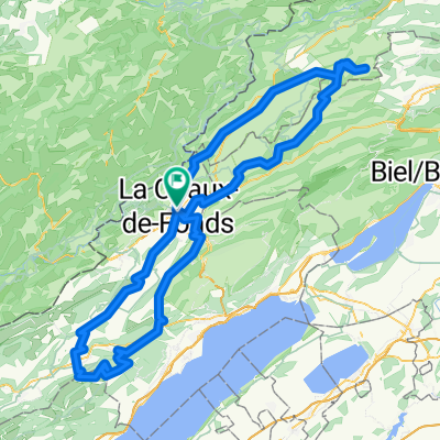
- La Chaus de Fonds-Le Locle-Les Brenets-Le Locle
- La Chaux-de-Fonds -Creux du VAn
- 156,3 km
- 3.940 m
- 3.940 m
- La Chaux-de-Fonds, Kanton Neuenburg, Schweiz
- La Chaux-de-Fonds to Porrentruy
- 81,2 km
- 1.431 m
- 1.997 m
- La Chaux-de-Fonds, Kanton Neuenburg, Schweiz
- Jura 4
- 41,8 km
- 439 m
- 693 m
- La Chaux-de-Fonds, Kanton Neuenburg, Schweiz
- Cibourg-Cortébert-Chasseral-LaVue
- 68 km
- 1.514 m
- 1.514 m
- La Chaux-de-Fonds, Kanton Neuenburg, Schweiz
- 3 - De la Chaux-de-Fonds aux Breuleux
- 32,1 km
- 286 m
- 247 m
- La Chaux-de-Fonds, Kanton Neuenburg, Schweiz
- La Chaux-de-Fonds - Foncine-le-Haut
- 122,3 km
- 1.361 m
- 1.549 m
- La Chaux-de-Fonds, Kanton Neuenburg, Schweiz
- Route in La Chaux-de-Fonds
- 90,8 km
- 2.563 m
- 2.565 m
- La Chaux-de-Fonds, Kanton Neuenburg, Schweiz
In der App öffnen


