


N - S - Naramata Based Loop
Eine Fahrradroute, die in Summerland, British Columbia, Kanada beginnt.
Übersicht
Über diese Route
6
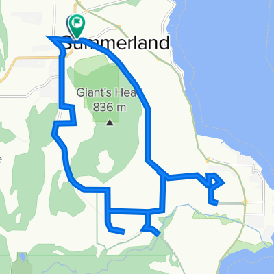
Wir beginnen in der Innenstadt von Naramata, nehmen eine Kombination aus Straßen und dem KVR-Trail zur Bench für einen Kaffee und fahren dann mit Stopps an verschiedenen Weingütern zurück, mit einem Zwischenstopp zum Mittagessen auf der Terrasse der Lake Breeze Winery. Zwei letzte Verkostungsstopps in Therapy, dann geht es zurück zur Herberge für den Tag.
- -:--
- Dauer
- 30,9 km
- Distanz
- 365 m
- Aufstieg
- 365 m
- Abstieg
- ---
- Ø-Tempo
- ---
- Max. Höhe
girookanagan
Erstellt vor 10 Jahren
Routenqualität
Wegtypen und Untergründe entlang der Route
Wegtypen
Ruhige Straße
11,4 km
37 %
Radweg
6,2 km
20 %
Untergründe
Befestigt
6,5 km
(21 %)
Unbefestigt
7,1 km
(23 %)
Asphalt
6,2 km
20 %
Schotter
6,2 km
20 %
Highlights der Route
POIs entlang der Route
Interessanter Ort nach 7,4 km
Bench 1775 Winery - wine tasting stop
Interessanter Ort nach 9,4 km
Poplar Grove Cheese Shop
Interessanter Ort nach 14,2 km
The Bench Coffee shop - stop for coffee
Interessanter Ort nach 25,7 km
Lake Breeze Winery - lunch stop
Interessanter Ort nach 26,6 km
Elephant Island Orchard - wine tasting stop
Interessanter Ort nach 28,9 km
Therapy Vineyards - Wine tasting stop
Weiter mit Bikemap
Diese Radroute verwenden, bearbeiten oder herunterladen
Du möchtest N - S - Naramata Based Loop fahren oder sie für deine eigene Reise anpassen? Folgendes kannst du mit dieser Bikemap-Route machen:
Gratis Funktionen
- Speichere diese Route als Favorit oder in einer Sammlung
- Kopiere & plane deine eigene Version dieser Route
- Synchronisiere deine Route mit Garmin oder Wahoo
Premium-Funktionen
Kostenlose Testversion für 3 Tage oder einmalige Zahlung. Mehr über Bikemap Premium.
- Navigiere diese Route auf iOS & Android
- Exportiere eine GPX / KML-Datei dieser Route
- Erstelle deinen individuellen Ausdruck (Jetzt kostenlos ausprobieren)
- Lade diese Route für die Offline-Navigation herunter
Entdecke weitere Premium-Funktionen.
Bikemap Premium aktivierenVon unserer Community
Summerland: Andere beliebte Routen, die hier beginnen


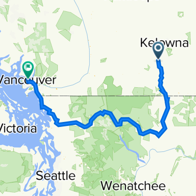 13020 Lakeshore Dr S, Summerland to 2791 Grant St, Vancouver0
- 586,9 km
- 3.770 m
- 4.060 m
- Summerland, British Columbia, Kanada


In der App öffnen