

A Coffee + Architecture + Platting + Infrastructure + Beer Exploration
Eine Fahrradroute, die in Portland, Oregon, Vereinigte Staaten beginnt.
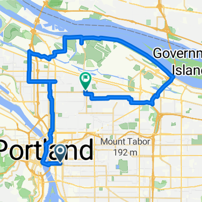
Übersicht
Über diese Route
Dinge, die wir sehen/unternehmen werden.
Wir werden die Steel Bridge überqueren - eine 104 Jahre alte Brücke, die Straßenbahnen, Busse, Fußgänger, Fahrräder, Güterzüge, Passagierzüge und auch Traktoren überquert. Sie ist das Arbeitstier von Portland seit 1912!
Cup & Bar - eine der neuesten Röstereien in der Stadt, liefert mit dem Lastenrad und hat einen offenen Bereich zum Chillen/Hacken/Fahrradfahren usw. in der Nähe von zwei der neuen schrägen Wohnhochhäuser, die gerade gebaut werden.
Ladd's Addition, eines der ersten Viertel, ein geplant Straßenbahnvierte, von Portland, das zwischen 1905 und 1930 parzelliert und gebaut wurde.
Apex Bar/Brauerei. Tolle Bar mit rockigen Tunes, mehr Fahrradparkplätze, als man sich vorstellen kann (und wir werden wahrscheinlich trotzdem an Bäumen abschließen) und einer äußerst beeindruckenden Bierauswahl lokaler Biere (Dutzende und Dutzende davon!).
Die Tillikum Bridge ist Portlands neue Verkehrs-, Rad- und Fußgängerbrücke. Wir werden entlang einiger neuer MUP (Mixed Use Path) bis zur Brücke fahren, wo du die Zusammenführung von Straßenbahnen, Straßenbahnen und Bussen, die über die Brücke fahren, sehen wirst und wahrscheinlich Fahrradfahrer und Fußgänger überall. Es ist eine coole Brücke, die erst letzten September eröffnet wurde!
Wir werden entlang dem südlichen Ende des Ufers von MUP (Mixed Use Path) zurückkehren.
- -:--
- Dauer
- 9,9 km
- Distanz
- 122 m
- Aufstieg
- 121 m
- Abstieg
- ---
- Ø-Tempo
- ---
- Max. Höhe

Routenqualität
Wegtypen und Untergründe entlang der Route
Wegtypen
Ruhige Straße
3,6 km
(36 %)
Radweg
2,7 km
(27 %)
Untergründe
Befestigt
8,6 km
(87 %)
Asphalt
3,9 km
(39 %)
Befestigt (undefiniert)
2,4 km
(24 %)
Weiter mit Bikemap
Diese Radroute verwenden, bearbeiten oder herunterladen
Du möchtest A Coffee + Architecture + Platting + Infrastructure + Beer Exploration fahren oder sie für deine eigene Reise anpassen? Folgendes kannst du mit dieser Bikemap-Route machen:
Gratis Funktionen
- Speichere diese Route als Favorit oder in einer Sammlung
- Kopiere & plane deine eigene Version dieser Route
- Synchronisiere deine Route mit Garmin oder Wahoo
Premium-Funktionen
Kostenlose Testversion für 3 Tage oder einmalige Zahlung. Mehr über Bikemap Premium.
- Navigiere diese Route auf iOS & Android
- Exportiere eine GPX / KML-Datei dieser Route
- Erstelle deinen individuellen Ausdruck (Jetzt kostenlos ausprobieren)
- Lade diese Route für die Offline-Navigation herunter
Entdecke weitere Premium-Funktionen.
Bikemap Premium aktivierenVon unserer Community
Portland: Andere beliebte Routen, die hier beginnen
 Modified Sellwood bridge route
- Distanz
- 18,5 km
- Aufstieg
- 211 m
- Abstieg
- 212 m
- Standort
- Portland, Oregon, Vereinigte Staaten
 Wednesday 9/24
- Distanz
- 37,7 km
- Aufstieg
- 225 m
- Abstieg
- 187 m
- Standort
- Portland, Oregon, Vereinigte Staaten
 august: a taylor swift ride v1
- Distanz
- 15,4 km
- Aufstieg
- 98 m
- Abstieg
- 103 m
- Standort
- Portland, Oregon, Vereinigte Staaten
 A Coffee + Architecture + Platting + Infrastructure + Beer Exploration
- Distanz
- 9,9 km
- Aufstieg
- 122 m
- Abstieg
- 121 m
- Standort
- Portland, Oregon, Vereinigte Staaten
 Waterfront 8/9/17
- Distanz
- 17 km
- Aufstieg
- 131 m
- Abstieg
- 133 m
- Standort
- Portland, Oregon, Vereinigte Staaten
 I-5 to 205 Loop
- Distanz
- 38,7 km
- Aufstieg
- 178 m
- Abstieg
- 180 m
- Standort
- Portland, Oregon, Vereinigte Staaten
 50mi loop to troutdale
- Distanz
- 75,9 km
- Aufstieg
- 278 m
- Abstieg
- 274 m
- Standort
- Portland, Oregon, Vereinigte Staaten
 august: a taylor swift ride v2
- Distanz
- 18,9 km
- Aufstieg
- 116 m
- Abstieg
- 121 m
- Standort
- Portland, Oregon, Vereinigte Staaten
In der App öffnen