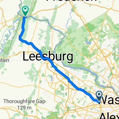
The Washington and Old Dominion Trail
Eine Fahrradroute, die in Dunn Loring, Virginia, United States of America beginnt.
Übersicht
Über diese Route
The Washington & Old Dominion Trail (W&OD or "Wad") is a great rail trail through the Northern Virginia counties. The entire 45 miles is paved with nine foot wide asphalt and has a painted yellow center line. There is also a parallel horse trail along much of the trail (which can be a nice diversion for ATBs). The only real complaints about this trail are its popularity (it can be quite crowded on some days) and the fact that much of it follows a power line right-of-way
The W&OD Trail begins in the Shirlington area of Arlington County, just off I-395 Exit 6. It ends "way-out" in rural Purcellville, VA. Along the way, it passes through quaint villages like Falls Church and Leesburg, and high-tech centers such as Reston and Herndon.
- -:--
- Dauer
- 56,8 km
- Distanz
- 295 m
- Aufstieg
- 247 m
- Abstieg
- ---
- Ø-Tempo
- ---
- Ø-Tempo
Routenqualität
Wegtypen und Untergründe entlang der Route
Wegtypen
Radweg
51 km
(90 %)
Ruhige Straße
3,5 km
(6 %)
Untergründe
Befestigt
43,5 km
(77 %)
Unbefestigt
11,7 km
(21 %)
Asphalt
42,2 km
(74 %)
Schotter
11,1 km
(20 %)
Weiter mit Bikemap
Diese Radroute verwenden, bearbeiten oder herunterladen
Du möchtest The Washington and Old Dominion Trail fahren oder sie für deine eigene Reise anpassen? Folgendes kannst du mit dieser Bikemap-Route machen:
Gratis Funktionen
- Speichere diese Route als Favorit oder in einer Sammlung
- Kopiere & plane deine eigene Version dieser Route
- Synchronisiere deine Route mit Garmin oder Wahoo
Premium-Funktionen
Kostenlose Testversion für 3 Tage oder einmalige Zahlung. Mehr über Bikemap Premium.
- Navigiere diese Route auf iOS & Android
- Exportiere eine GPX / KML-Datei dieser Route
- Erstelle deinen individuellen Ausdruck (Jetzt kostenlos ausprobieren)
- Lade diese Route für die Offline-Navigation herunter
Entdecke weitere Premium-Funktionen.
Bikemap Premium aktivierenVon unserer Community
Dunn Loring: Andere beliebte Routen, die hier beginnen
 2547 Gallows Rd, Dunn Loring to 2670 Avenir Pl, Vienna
- Distanz
- 24,7 km
- Aufstieg
- 143 m
- Abstieg
- 147 m
- Standort
- Dunn Loring, Virginia, USA
 Washington Old Dominion
- Distanz
- 16,4 km
- Aufstieg
- 110 m
- Abstieg
- 239 m
- Standort
- Dunn Loring, Virginia, USA
 Olympic Tri Distance
- Distanz
- 40,1 km
- Aufstieg
- 206 m
- Abstieg
- 206 m
- Standort
- Dunn Loring, Virginia, USA
 8/14 Exploration
- Distanz
- 10,4 km
- Aufstieg
- 154 m
- Abstieg
- 159 m
- Standort
- Dunn Loring, Virginia, USA
 Route from Sandburg St, Dunn Loring
- Distanz
- 9,2 km
- Aufstieg
- 41 m
- Abstieg
- 106 m
- Standort
- Dunn Loring, Virginia, USA
 Bike to work
- Distanz
- 9,8 km
- Aufstieg
- 56 m
- Abstieg
- 109 m
- Standort
- Dunn Loring, Virginia, USA
 2414–2422 Holt St, Vienna to Jefferson Pike, Purcellville
- Distanz
- 75,1 km
- Aufstieg
- 374 m
- Abstieg
- 401 m
- Standort
- Dunn Loring, Virginia, USA
 Home to the embassy
- Distanz
- 22,6 km
- Aufstieg
- 149 m
- Abstieg
- 220 m
- Standort
- Dunn Loring, Virginia, USA
In der App öffnen


