
24 h challenge
Eine Fahrradroute, die in Potoci, Föderation Bosnien und Herzegowina, Bosnien und Herzegowina beginnt.
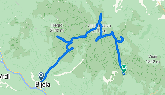
Übersicht
Über diese Route
jesusmarija
- -:--
- Dauer
- 36,1 km
- Distanz
- 3.558 m
- Aufstieg
- 2.275 m
- Abstieg
- ---
- Ø-Tempo
- ---
- Max. Höhe

Highlights der Route
POIs entlang der Route
Unterkunft nach 6,6 km
NOVI KONTEJNER
Interessanter Ort nach 6,7 km
OVČA
Interessanter Ort nach 11 km
HERAČ
Interessanter Ort nach 11,8 km
VIDINA KAPA
Interessanter Ort nach 13,4 km
LUPOGLAV
Interessanter Ort nach 14,5 km
VJETRENA BRDA -ERAČ
Interessanter Ort nach 20,4 km
VELIKA KAPA
Interessanter Ort nach 23,3 km
OTIŠ
Interessanter Ort nach 23,7 km
ZELENA GLAVA
Interessanter Ort nach 24,4 km
BOTINI
Unterkunft nach 27,2 km
JEZERCE
Interessanter Ort nach 30,1 km
V. OSOBAC
Interessanter Ort nach 36,1 km
BIJELE VODE
Weiter mit Bikemap
Diese Radroute verwenden, bearbeiten oder herunterladen
Du möchtest 24 h challenge fahren oder sie für deine eigene Reise anpassen? Folgendes kannst du mit dieser Bikemap-Route machen:
Gratis Funktionen
- Speichere diese Route als Favorit oder in einer Sammlung
- Kopiere & plane deine eigene Version dieser Route
- Synchronisiere deine Route mit Garmin oder Wahoo
Premium-Funktionen
Kostenlose Testversion für 3 Tage oder einmalige Zahlung. Mehr über Bikemap Premium.
- Navigiere diese Route auf iOS & Android
- Exportiere eine GPX / KML-Datei dieser Route
- Erstelle deinen individuellen Ausdruck (Jetzt kostenlos ausprobieren)
- Lade diese Route für die Offline-Navigation herunter
Entdecke weitere Premium-Funktionen.
Bikemap Premium aktivierenVon unserer Community
Potoci: Andere beliebte Routen, die hier beginnen
 24 h challenge
- Distanz
- 36,1 km
- Aufstieg
- 3.558 m
- Abstieg
- 2.275 m
- Standort
- Potoci, Föderation Bosnien und Herzegowina, Bosnien und Herzegowina
 RUTA, Semetovac-Put za rosca
- Distanz
- 24,6 km
- Aufstieg
- 548 m
- Abstieg
- 548 m
- Standort
- Potoci, Föderation Bosnien und Herzegowina, Bosnien und Herzegowina
 RUTA, Potoci, Rošca, Rujište, Potoci
- Distanz
- 34,4 km
- Aufstieg
- 1.247 m
- Abstieg
- 1.247 m
- Standort
- Potoci, Föderation Bosnien und Herzegowina, Bosnien und Herzegowina
 RUTA, Kuti - Grabovica
- Distanz
- 32,3 km
- Aufstieg
- 372 m
- Abstieg
- 381 m
- Standort
- Potoci, Föderation Bosnien und Herzegowina, Bosnien und Herzegowina
 Rujište 2
- Distanz
- 44,4 km
- Aufstieg
- 848 m
- Abstieg
- 861 m
- Standort
- Potoci, Föderation Bosnien und Herzegowina, Bosnien und Herzegowina
 raska goraa
- Distanz
- 7,6 km
- Aufstieg
- 453 m
- Abstieg
- 73 m
- Standort
- Potoci, Föderation Bosnien und Herzegowina, Bosnien und Herzegowina
 Rujiste-Boracko
- Distanz
- 56,5 km
- Aufstieg
- 1.170 m
- Abstieg
- 1.170 m
- Standort
- Potoci, Föderation Bosnien und Herzegowina, Bosnien und Herzegowina

2909®
Humulisani Loop : by Špinavá Parta- Distanz
- 34,7 km
- Aufstieg
- 690 m
- Abstieg
- 692 m
- Standort
- Potoci, Föderation Bosnien und Herzegowina, Bosnien und Herzegowina
In der App öffnen