

St Ninian's Way - Glenluce to New Luce
Eine Fahrradroute, die in Stranraer, Schottland, Vereinigtes Königreich beginnt.
Übersicht
Über diese Route
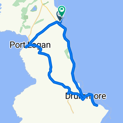
This 15th section of St Ninian's Way starts at Glenluce crossroads and heads north- west along road and track for 2 km to Glenluce Abbey. Continue along east bank of the Water of Luce 4 km to Cruise (crossroads with Southern Upland Way) and continue 2 km to New Luce (Conservation Village)
Alternatively, for an extra 6 km, at Cruise take the Southern Upland Way going East for 5 km to the road and waterfall on the Cross Water of Luce, then take the minor road back to New Luce.
Gently undulating along the Luce valley
Also part of the Whithorn Way - http://www.whithornway.org . courtesy of the WWSG where a detailed route description with grid references is available.
For a map overview of Part 1 and Part 2 of St Ninian’s Way please go to https://www.bikemap.net/en/route/3548129-st-ninians-way-carlisle-to-st-andrews-part-1-carlisle-to-whithorn/
St Ninian’s Way is one of the great pilgrim routes in Scotland to St Andrews - The Way of St Andrews - For other routes see http://www.thewayofstandrews.com
- -:--
- Dauer
- 8,2 km
- Distanz
- 101 m
- Aufstieg
- 78 m
- Abstieg
- ---
- Ø-Tempo
- ---
- Max. Höhe

Routenqualität
Wegtypen und Untergründe entlang der Route
Wegtypen
Straße
6,4 km
(78 %)
Zufahrtsstraße
1 km
(12 %)
Untergründe
Befestigt
1,6 km
(20 %)
Asphalt
1,6 km
(20 %)
Undefiniert
6,6 km
(80 %)
Highlights der Route
POIs entlang der Route
Interessanter Ort nach 2,5 km
Glenluce Abbey
Interessanter Ort nach 6,8 km
Joins Southern Upland Way , with 6 km detour to New Luce
Weiter mit Bikemap
Diese Radroute verwenden, bearbeiten oder herunterladen
Du möchtest St Ninian's Way - Glenluce to New Luce fahren oder sie für deine eigene Reise anpassen? Folgendes kannst du mit dieser Bikemap-Route machen:
Gratis Funktionen
- Speichere diese Route als Favorit oder in einer Sammlung
- Kopiere & plane deine eigene Version dieser Route
- Synchronisiere deine Route mit Garmin oder Wahoo
Premium-Funktionen
Kostenlose Testversion für 3 Tage oder einmalige Zahlung. Mehr über Bikemap Premium.
- Navigiere diese Route auf iOS & Android
- Exportiere eine GPX / KML-Datei dieser Route
- Erstelle deinen individuellen Ausdruck (Jetzt kostenlos ausprobieren)
- Lade diese Route für die Offline-Navigation herunter
Entdecke weitere Premium-Funktionen.
Bikemap Premium aktivierenVon unserer Community
Stranraer: Andere beliebte Routen, die hier beginnen
 Barhill, Newton Stewart, and back
- Distanz
- 80,3 km
- Aufstieg
- 524 m
- Abstieg
- 524 m
- Standort
- Stranraer, Schottland, Vereinigtes Königreich
 voyage2_Ecosse
- Distanz
- 1.979,8 km
- Aufstieg
- 1.663 m
- Abstieg
- 1.652 m
- Standort
- Stranraer, Schottland, Vereinigtes Königreich
 NEB Drumore PL loop
- Distanz
- 20,6 km
- Aufstieg
- 3 m
- Abstieg
- 6 m
- Standort
- Stranraer, Schottland, Vereinigtes Königreich
 1.3 Southern Upland Way
- Distanz
- 25,6 km
- Aufstieg
- 385 m
- Abstieg
- 340 m
- Standort
- Stranraer, Schottland, Vereinigtes Königreich
 Ride up the coast from Portpatrick and round the top
- Distanz
- 42,8 km
- Aufstieg
- 340 m
- Abstieg
- 340 m
- Standort
- Stranraer, Schottland, Vereinigtes Königreich
 Glenluce-Newton Stewart-New Luce
- Distanz
- 71,4 km
- Aufstieg
- 376 m
- Abstieg
- 376 m
- Standort
- Stranraer, Schottland, Vereinigtes Königreich
 Barhill and back
- Distanz
- 57,2 km
- Aufstieg
- 395 m
- Abstieg
- 387 m
- Standort
- Stranraer, Schottland, Vereinigtes Königreich
 1.2 Southern upland way
- Distanz
- 10,5 km
- Aufstieg
- 152 m
- Abstieg
- 123 m
- Standort
- Stranraer, Schottland, Vereinigtes Königreich
In der App öffnen