

St Ninians's Way- Colmonell to Girvan
Eine Fahrradroute, die in Girvan, Schottland, Vereinigtes Königreich beginnt.
Übersicht
Über diese Route
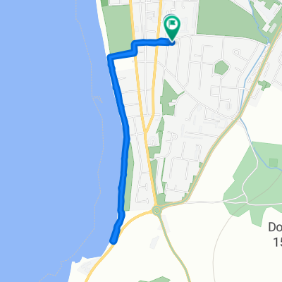
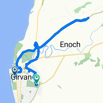
This 18th section of St Ninian’s Way starts at the crossroads of Colmonell. Go north onto track and past ruined castle to join the main road B734 (200 m). Then turn right and along road and cross bridge (100 m). Leave road and take track going north through wood (200 m ). Continue North along track with Clauchanton Hill to the right to arrive at small loch at the bottom of Lochton Hill (2 km). Continue along valley between Lochton Hill and Knockormal Hill then swing to the east along the track to arrive at a T-junction with a quiet road (2km) Go left-north- along road to Lendalfoot (1.5km) and T-junction where it joins the A77 and Ayrshire Coastal Path (signposted) . Turn right along ACP and proceed to Girvan town centre and harbour (7 km).
Steep and hilly then coastal path.
Also part of the Whithorn Way - http://www.whithornway.org . courtesy of the WWSG where a detailed route description with grid references is available.
For a map overview of Part 1 and Part 2 of St Ninian’s Way please go to https://www.bikemap.net/en/route/3548129-st-ninians-way-carlisle-to-st-andrews-part-1-carlisle-to-whithorn/
St Ninian’s Way is one of the great pilgrim routes in Scotland to St Andrews - The Way of St Andrews - For other routes see http://www.thewayofstandrews.com
- -:--
- Dauer
- 17,3 km
- Distanz
- 303 m
- Aufstieg
- 332 m
- Abstieg
- ---
- Ø-Tempo
- ---
- Max. Höhe

Weiter mit Bikemap
Diese Radroute verwenden, bearbeiten oder herunterladen
Du möchtest St Ninians's Way- Colmonell to Girvan fahren oder sie für deine eigene Reise anpassen? Folgendes kannst du mit dieser Bikemap-Route machen:
Gratis Funktionen
- Speichere diese Route als Favorit oder in einer Sammlung
- Kopiere & plane deine eigene Version dieser Route
- Synchronisiere deine Route mit Garmin oder Wahoo
Premium-Funktionen
Kostenlose Testversion für 3 Tage oder einmalige Zahlung. Mehr über Bikemap Premium.
- Navigiere diese Route auf iOS & Android
- Exportiere eine GPX / KML-Datei dieser Route
- Erstelle deinen individuellen Ausdruck (Jetzt kostenlos ausprobieren)
- Lade diese Route für die Offline-Navigation herunter
Entdecke weitere Premium-Funktionen.
Bikemap Premium aktivierenVon unserer Community
Girvan: Andere beliebte Routen, die hier beginnen
 Girvan Mini Gravel
- Distanz
- 12,8 km
- Aufstieg
- 160 m
- Abstieg
- 160 m
- Standort
- Girvan, Schottland, Vereinigtes Königreich
 Hervey Road 1 to Hervey Road 1
- Distanz
- 3,3 km
- Aufstieg
- 66 m
- Abstieg
- 58 m
- Standort
- Girvan, Schottland, Vereinigtes Königreich
 Sophie and emma
- Distanz
- 10,1 km
- Aufstieg
- 230 m
- Abstieg
- 219 m
- Standort
- Girvan, Schottland, Vereinigtes Königreich
 23 Back Road, Girvan to 47 Main Street, Girvan
- Distanz
- 100,4 km
- Aufstieg
- 1.279 m
- Abstieg
- 1.285 m
- Standort
- Girvan, Schottland, Vereinigtes Königreich
 Old Daily - Maybole circuit
- Distanz
- 58,7 km
- Aufstieg
- 550 m
- Abstieg
- 552 m
- Standort
- Girvan, Schottland, Vereinigtes Königreich
 11 Back Road, Girvan to 47 Main Street, Girvan
- Distanz
- 23,9 km
- Aufstieg
- 488 m
- Abstieg
- 496 m
- Standort
- Girvan, Schottland, Vereinigtes Königreich
 Hervey Road 1 to The Clachan 36, Barr
- Distanz
- 13,7 km
- Aufstieg
- 288 m
- Abstieg
- 188 m
- Standort
- Girvan, Schottland, Vereinigtes Königreich
 Girvan and South Carrick Ward, Girvan to Girvan and South Carrick Ward, Girvan
- Distanz
- 13,2 km
- Aufstieg
- 187 m
- Abstieg
- 187 m
- Standort
- Girvan, Schottland, Vereinigtes Königreich
In der App öffnen