

Sella Ronda clockwise completed (facut)
Eine Fahrradroute, die in Abtei, Trentino-Südtirol, Italien beginnt.
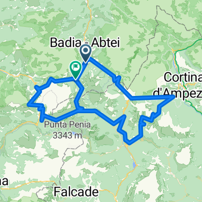
Übersicht
Über diese Route
Sella Ronda im Uhrzeigersinn abgeschlossen, unter Verwendung aller Lifte wie in deren Prospekten beschrieben.
Gestartet von La Villa / Stern (und am selben Ort wieder beendet);
Nehmen Sie den Piz la Villa Aufzug von La Villa. Dies anstelle des Col Alt von Corvara (wenn Sie in La Villa starten).
Folgen Sie dem Pfad hinunter nach Pass Campolongo. Nehmen Sie den Campolongo / Bec de Roces Aufzug.
Folgen Sie dem Pfad hinunter nach Arabba. Nehmen Sie den Porta Vescovo Aufzug.
Gehen Sie hinunter zum Pont de Vauz. Nehmen Sie den Fodom Aufzug.
Fahren Sie hinunter (teilweise auf der Straße) nach Canazei und dann nach Campitello. Nehmen Sie den Col Rodella Aufzug.
Folgen Sie dem Pfad nach Selva Gardena / Wolkenstein. Nehmen Sie die Dantercepies Linie (bis zum Gipfel, steigen Sie NICHT an der Zwischenstation aus).
Fahren Sie hinunter nach Corvara.
Jetzt haben Sie die Wahl, ob Sie nach La Villa auf der Straße fahren (schnell und die einzige Option, wenn es nach 17:30 ist) oder wieder über Col Alt und Baia Fraida hinauffahren; dann hinunter nach La Villa.
Achtung: Es ist ein Langer Trail und wenn Sie anhalten (auch nur kurz) oder eine Mittagspause machen, kommen Sie später als 17:30 an. Sie werden die unangenehme Überraschung erleben, dass Sie die letzte Fahrt mit dem Aufzug nicht erwischen (da die meisten zu dieser Zeit schließen).
Starten Sie um 8:30 (wenn die Aufzüge in Betrieb genommen werden) ist EIN MUSS.
Also, Sie sind gewarnt.
Ansonsten eine ausgezeichnete Strecke mit atemberaubender Landschaft,
- -:--
- Dauer
- 66,4 km
- Distanz
- 3.370 m
- Aufstieg
- 3.369 m
- Abstieg
- ---
- Ø-Tempo
- ---
- Max. Höhe

Weiter mit Bikemap
Diese Radroute verwenden, bearbeiten oder herunterladen
Du möchtest Sella Ronda clockwise completed (facut) fahren oder sie für deine eigene Reise anpassen? Folgendes kannst du mit dieser Bikemap-Route machen:
Gratis Funktionen
- Speichere diese Route als Favorit oder in einer Sammlung
- Kopiere & plane deine eigene Version dieser Route
- Synchronisiere deine Route mit Garmin oder Wahoo
Premium-Funktionen
Kostenlose Testversion für 3 Tage oder einmalige Zahlung. Mehr über Bikemap Premium.
- Navigiere diese Route auf iOS & Android
- Exportiere eine GPX / KML-Datei dieser Route
- Erstelle deinen individuellen Ausdruck (Jetzt kostenlos ausprobieren)
- Lade diese Route für die Offline-Navigation herunter
Entdecke weitere Premium-Funktionen.
Bikemap Premium aktivierenVon unserer Community
Abtei: Andere beliebte Routen, die hier beginnen
 Strada Armuntarora nach Passo Falzarego
- Distanz
- 11,6 km
- Aufstieg
- 701 m
- Abstieg
- 139 m
- Standort
- Abtei, Trentino-Südtirol, Italien
 hotel-linder-neu-groeden-pralongia-hochplateau - proposed
- Distanz
- 45,5 km
- Aufstieg
- 2.099 m
- Abstieg
- 2.099 m
- Standort
- Abtei, Trentino-Südtirol, Italien
 Sella Ronda clockwise completed (facut)
- Distanz
- 66,4 km
- Aufstieg
- 3.370 m
- Abstieg
- 3.369 m
- Standort
- Abtei, Trentino-Südtirol, Italien
 Giro Val Badia
- Distanz
- 54,8 km
- Aufstieg
- 1.942 m
- Abstieg
- 1.944 m
- Standort
- Abtei, Trentino-Südtirol, Italien
 I parchi
- Distanz
- 32,6 km
- Aufstieg
- 1.170 m
- Abstieg
- 1.171 m
- Standort
- Abtei, Trentino-Südtirol, Italien
 140 Maraton DOLOMITI
- Distanz
- 144,1 km
- Aufstieg
- 5.971 m
- Abstieg
- 5.870 m
- Standort
- Abtei, Trentino-Südtirol, Italien
 Kirche San Leonardo - Kirche Heilig Kreuz
- Distanz
- 15,8 km
- Aufstieg
- 933 m
- Abstieg
- 933 m
- Standort
- Abtei, Trentino-Südtirol, Italien
 Campolongo_Pellegrino_Valles_2015_2
- Distanz
- 104,3 km
- Aufstieg
- 2.326 m
- Abstieg
- 2.684 m
- Standort
- Abtei, Trentino-Südtirol, Italien
In der App öffnen