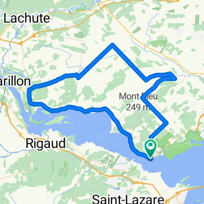
Parcours des Traverses - Montagne
Eine Fahrradroute, die in Oka, Québec, Kanada beginnt.
Übersicht
Über diese Route
Ob Sie sich entscheiden, entlang des Ufers des Lac des Deux-Montagnes (60 km) zu fahren, oder die große Runde zu wählen, die durch die Felder, Dörfer und Hügel der Basses-Laurentides und Vaudreuil-Soulanges (140 km) windet, der Parcours des traverses transportiert Sie von einem Ufer zum anderen und eröffnet Ihnen zahlreiche Gelegenheiten, spektakuläre Ausblicke und eine Vielfalt bezaubernder Landschaften zu entdecken.
Ideal für einen Tagesausflug oder einen längeren Aufenthalt in der prächtigen Region Lac des Deux-Montagnes, verspricht dieser Pfad den Radfahrern ein unvergessliches Erlebnis. Nutzen Sie die Gastfreundschaft der entlang des Weges gelegenen Campingplätze, B&Bs, Gasthäuser und Hotels.
Radeln Sie entlang des Ottawa-Flusses und genießen Sie den Panoramablick auf die Uferlinie und den Mont Rigaud. Planen Sie einen Zwischenstopp im Park Chartier-De Lotbinière in der Stadt Rigaud ein, bevor Sie den Hang des Berges in Richtung Innenstadt von Vaudreuil-Dorion weiterfahren. Diese Route bietet zahlreiche Gelegenheiten, die Architektur und Geschichte der Region zu bewundern.
- -:--
- Dauer
- 144,7 km
- Distanz
- 368 m
- Aufstieg
- 368 m
- Abstieg
- ---
- Ø-Tempo
- ---
- Max. Höhe
Highlights der Route
POIs entlang der Route

Interessanter Ort nach 62,2 km
Lieu historique national du Canal-de-Carillon

Interessanter Ort nach 62,8 km
Traversier Le Passeur

Interessanter Ort nach 64 km
Ferme les Petites Écores

Interessanter Ort nach 75,6 km
Parc Chartier-De-Lotbinière

Interessanter Ort nach 115,3 km
Jardin Champs de rêves

Interessanter Ort nach 129,3 km
Maison Trestler

Interessanter Ort nach 131,3 km
Musée régional de Vaudreuil-Soulanges

Interessanter Ort nach 137,2 km
Maison Félix Leclerc

Interessanter Ort nach 142,9 km
Traverse Oka-Hudson
Weiter mit Bikemap
Diese Radroute verwenden, bearbeiten oder herunterladen
Du möchtest Parcours des Traverses - Montagne fahren oder sie für deine eigene Reise anpassen? Folgendes kannst du mit dieser Bikemap-Route machen:
Gratis Funktionen
- Speichere diese Route als Favorit oder in einer Sammlung
- Kopiere & plane deine eigene Version dieser Route
- Teile sie in Etappen ein, um eine mehrtägige Tour zu erstellen
- Synchronisiere deine Route mit Garmin oder Wahoo
Premium-Funktionen
Kostenlose Testversion für 3 Tage oder einmalige Zahlung. Mehr über Bikemap Premium.
- Navigiere diese Route auf iOS & Android
- Exportiere eine GPX / KML-Datei dieser Route
- Erstelle deinen individuellen Ausdruck (Jetzt kostenlos ausprobieren)
- Lade diese Route für die Offline-Navigation herunter
Entdecke weitere Premium-Funktionen.
Bikemap Premium aktivierenVon unserer Community
Oka: Andere beliebte Routen, die hier beginnen
 Un autre beau tour derrière Oka
- Distanz
- 76,6 km
- Aufstieg
- 293 m
- Abstieg
- 293 m
- Standort
- Oka, Québec, Kanada
 Oka 02
- Distanz
- 73,2 km
- Aufstieg
- 259 m
- Abstieg
- 259 m
- Standort
- Oka, Québec, Kanada
 homa oka
- Distanz
- 58 km
- Aufstieg
- 147 m
- Abstieg
- 151 m
- Standort
- Oka, Québec, Kanada
 Parcours des Traverses - Montagne
- Distanz
- 144,7 km
- Aufstieg
- 368 m
- Abstieg
- 368 m
- Standort
- Oka, Québec, Kanada
 Oka Loop
- Distanz
- 45,4 km
- Aufstieg
- 314 m
- Abstieg
- 315 m
- Standort
- Oka, Québec, Kanada
 Rue Main 208, Hudson to Rue Rollande 15, Rigaud
- Distanz
- 20 km
- Aufstieg
- 65 m
- Abstieg
- 59 m
- Standort
- Oka, Québec, Kanada
 ERVLB 40 km
- Distanz
- 38,7 km
- Aufstieg
- 156 m
- Abstieg
- 154 m
- Standort
- Oka, Québec, Kanada
 The Willow 110k
- Distanz
- 110,2 km
- Aufstieg
- 183 m
- Abstieg
- 183 m
- Standort
- Oka, Québec, Kanada
In der App öffnen


