Harvey Square to Bathgo Avenue
- 26,1 km
- 113 m
- 180 m
- Lochwinnoch, Schottland, Vereinigtes Königreich
Eine Fahrradroute, die in Lochwinnoch, Schottland, Vereinigtes Königreich beginnt.
Übersicht
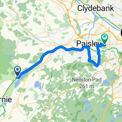
Lochwinnoch nach Paisley
Dieser 24. Abschnitt des St. Ninian’s Way folgt einem ausgeschilderten Fußweg und dem National Cycle Route 7 bis nach Paisley. Der Ausgangspunkt ist der Fußweg neben dem Castle Semple Loch, der zu einer Brücke über eine Autobahn führt (6 km). Dann fahren Sie weiter nach Norden entlang des Black Cart Water zu einer weiteren Brücke (2 km). Überqueren Sie die Brücke und folgen Sie dem Weg nach Elderslie (1,5 km), und dann weiter nach Sauce Hill, nur südlich von Paisley (3 km). Nehmen Sie dann die Causeyside Road 200 m und biegen Sie rechts in die Gordon Street ab, über die River Clyde, auf die Cotton Street zur Paisley Abbey (300 m). Eine Option ist, weiter auf die Gauze Street zu gehen und zu den Kreuzungen mit der St. Mirren’s katholischen Kathedrale.
Malereischer und ausgeschilderter Fußweg
Teil des Whithorn Way - http://www.whithornway.org . Dank der WWSG, wo eine detaillierte Routenbeschreibung mit Gitterreferenzen verfügbar ist.
Für eine Kartenübersicht von Teil 1 und Teil 2 des St Ninian’s Way besuchen Sie bitte https://www.bikemap.net/en/route/3548129-st-ninians-way-carlisle-to-st-andrews-part-1-carlisle-to-whithorn/
St. Ninian’s Way ist einer der großen Pilgerwege in Schottland nach St. Andrews - Der Weg von St. Andrews - Für andere Routen siehe http://www.thewayofstandrews.com
Erstellt vor 9 Jahren
Routenqualität
Radweg
14,5 km
(91 %)
Straße
0,2 km
(1 %)
Befestigt
14,8 km
(93 %)
Asphalt
14,8 km
(93 %)
Undefiniert
1,1 km
(7 %)
Highlights der Route
St Mirin's Cathedral
Paisley Abbey
Weiter mit Bikemap
Du möchtest St Ninian's Way - Lochwinnoch to Paisley fahren oder sie für deine eigene Reise anpassen? Folgendes kannst du mit dieser Bikemap-Route machen:
Kostenlose Testversion für 3 Tage oder einmalige Zahlung. Mehr über Bikemap Premium.
Entdecke weitere Premium-Funktionen.
Bikemap Premium aktivierenVon unserer Community
In der App öffnen