

Cycling in Seoul: along the Han river
Eine Fahrradroute, die in Seoul, Seoul, Republik Korea beginnt.
Übersicht
Über diese Route
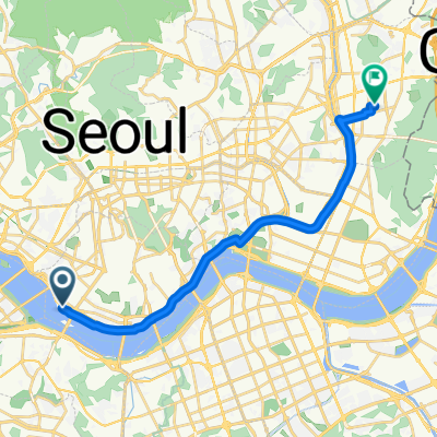
Start from one of the bicycle rental stations in Yeouido Hangang Park. Cross the Han over the Mapo Bridge, keep left and look for the blue ramp that takes you down to the river. Continue westwards until you meet Yanghwa Bridge. Carry your bike up the steps at the bridge and cycle across until the exit for Seonyudo Park. There's a café at the west end of the island. Continue across Yanghwa Bridge, there is a bike elevator to take you back down to the river. Cycle eastwards, past the Seoul Marina and the National Assembly Hall, until you are in Yeouido Hangang Park once again.
- -:--
- Dauer
- 13,1 km
- Distanz
- 137 m
- Aufstieg
- 137 m
- Abstieg
- ---
- Ø-Tempo
- ---
- Max. Höhe

Highlights der Route
POIs entlang der Route
Trinkwasser nach 0 km
Drinking water fountain
Interessanter Ort nach 0 km
Bicycle rental station
Interessanter Ort nach 1,4 km
Bicycle rental station
Interessanter Ort nach 11,7 km
Bicycle rental station
Weiter mit Bikemap
Diese Radroute verwenden, bearbeiten oder herunterladen
Du möchtest Cycling in Seoul: along the Han river fahren oder sie für deine eigene Reise anpassen? Folgendes kannst du mit dieser Bikemap-Route machen:
Gratis Funktionen
- Speichere diese Route als Favorit oder in einer Sammlung
- Kopiere & plane deine eigene Version dieser Route
- Synchronisiere deine Route mit Garmin oder Wahoo
Premium-Funktionen
Kostenlose Testversion für 3 Tage oder einmalige Zahlung. Mehr über Bikemap Premium.
- Navigiere diese Route auf iOS & Android
- Exportiere eine GPX / KML-Datei dieser Route
- Erstelle deinen individuellen Ausdruck (Jetzt kostenlos ausprobieren)
- Lade diese Route für die Offline-Navigation herunter
Entdecke weitere Premium-Funktionen.
Bikemap Premium aktivierenVon unserer Community
Seoul: Andere beliebte Routen, die hier beginnen
 ride from Yongsan-gu to Seongnamsi
- Distanz
- 27,7 km
- Aufstieg
- 87 m
- Abstieg
- 87 m
- Standort
- Seoul, Seoul, Republik Korea
 보통 경로
보통 경로- Distanz
- 19,6 km
- Aufstieg
- 94 m
- Abstieg
- 97 m
- Standort
- Seoul, Seoul, Republik Korea
 Seoul-Busan V2013
- Distanz
- 435,8 km
- Aufstieg
- 1.043 m
- Abstieg
- 1.036 m
- Standort
- Seoul, Seoul, Republik Korea
 zeppelin_viaggiamondo_corea_2013
- Distanz
- 835,5 km
- Aufstieg
- 5.814 m
- Abstieg
- 5.824 m
- Standort
- Seoul, Seoul, Republik Korea
 홍은동 22 to 경서동 526−2
- Distanz
- 47,2 km
- Aufstieg
- 338 m
- Abstieg
- 419 m
- Standort
- Seoul, Seoul, Republik Korea
 여의도-반포-잠실 한강 라이딩 코스
- Distanz
- 16,7 km
- Aufstieg
- 223 m
- Abstieg
- 224 m
- Standort
- Seoul, Seoul, Republik Korea
 test
test- Distanz
- 39,4 km
- Aufstieg
- 439 m
- Abstieg
- 439 m
- Standort
- Seoul, Seoul, Republik Korea
![명륜2가 125-2Ph0]으로 라우팅](https://media.bikemap.net/routes/14650463/gallery/thumbs/94673db0-bb2e-4818-a872-aa2a1241d2ca.jpg.208x208_q80_crop.jpg) 명륜2가 125-2Ph0]으로 라우팅
명륜2가 125-2Ph0]으로 라우팅- Distanz
- 70,9 km
- Aufstieg
- 1.522 m
- Abstieg
- 1.581 m
- Standort
- Seoul, Seoul, Republik Korea
In der App öffnen