

roachesetc
Eine Fahrradroute, die in Ashbourne, England, United Kingdom beginnt.
Übersicht
Über diese Route
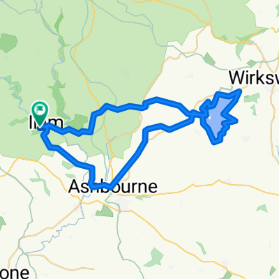
Mostly quiet roads loop, taking in some of the most scenic parts of the western peak district, especially Chrome Hill near Hollinsclough and The Roaches south of Flash. Starts near the National Trust site in Ilam, which has a car park and tea rooms. Sections of the route will be quite exposed, so mind the weather. Plus it's the Peak District and it doesn't stick to the rivers, so be prepared for some hills. Views are worth it though.
- -:--
- Dauer
- 66,3 km
- Distanz
- 941 m
- Aufstieg
- 933 m
- Abstieg
- ---
- Ø-Tempo
- ---
- Ø-Tempo
Routenqualität
Wegtypen und Untergründe entlang der Route
Wegtypen
Ruhige Straße
45,3 km
(68 %)
Straße
15,5 km
(23 %)
Untergründe
Befestigt
16,2 km
(24 %)
Asphalt
16,2 km
(24 %)
Undefiniert
50,1 km
(76 %)
Weiter mit Bikemap
Diese Radroute verwenden, bearbeiten oder herunterladen
Du möchtest roachesetc fahren oder sie für deine eigene Reise anpassen? Folgendes kannst du mit dieser Bikemap-Route machen:
Gratis Funktionen
- Speichere diese Route als Favorit oder in einer Sammlung
- Kopiere & plane deine eigene Version dieser Route
- Synchronisiere deine Route mit Garmin oder Wahoo
Premium-Funktionen
Kostenlose Testversion für 3 Tage oder einmalige Zahlung. Mehr über Bikemap Premium.
- Navigiere diese Route auf iOS & Android
- Exportiere eine GPX / KML-Datei dieser Route
- Erstelle deinen individuellen Ausdruck (Jetzt kostenlos ausprobieren)
- Lade diese Route für die Offline-Navigation herunter
Entdecke weitere Premium-Funktionen.
Bikemap Premium aktivierenVon unserer Community
Ashbourne: Andere beliebte Routen, die hier beginnen
 C38.5 WPC
- Distanz
- 62,3 km
- Aufstieg
- 355 m
- Abstieg
- 357 m
- Standort
- Ashbourne, England, Vereinigtes Königreich
 Milldale - Hall Dale Walk
- Distanz
- 10,5 km
- Aufstieg
- 247 m
- Abstieg
- 248 m
- Standort
- Ashbourne, England, Vereinigtes Königreich
 09.2018 Cov-M'cr-Cov. Dzien 2/3
- Distanz
- 59,4 km
- Aufstieg
- 491 m
- Abstieg
- 783 m
- Standort
- Ashbourne, England, Vereinigtes Königreich
 Route 10 Carsington Water circular
- Distanz
- 43,6 km
- Aufstieg
- 513 m
- Abstieg
- 514 m
- Standort
- Ashbourne, England, Vereinigtes Königreich
 Tissington and High Peak Trails (and the roady thing to join up the ends)
- Distanz
- 55,6 km
- Aufstieg
- 437 m
- Abstieg
- 437 m
- Standort
- Ashbourne, England, Vereinigtes Königreich
 Thorpe - Youlgreave - Darley Bridge - Matlock - Riber - Cromford - Wirksworth - Kirk Ireton - Carsington Water - Tissington - Thorpe
- Distanz
- 69 km
- Aufstieg
- 867 m
- Abstieg
- 868 m
- Standort
- Ashbourne, England, Vereinigtes Königreich
 ride in the peak district
- Distanz
- 50,1 km
- Aufstieg
- 723 m
- Abstieg
- 723 m
- Standort
- Ashbourne, England, Vereinigtes Königreich
 Trissington circle
- Distanz
- 28 km
- Aufstieg
- 311 m
- Abstieg
- 305 m
- Standort
- Ashbourne, England, Vereinigtes Königreich
In der App öffnen