

Zliechov-Čičmany-Rajecká Lesná
Eine Fahrradroute, die in Považská Bystrica, Trencin, Slowakei beginnt.
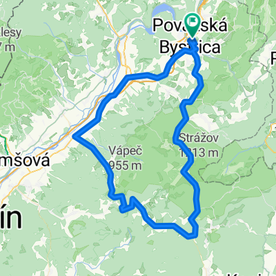
Übersicht
Über diese Route
Von P. Podhradie über Sverepec nach Trstie und unter Malenica bis nach Zliechov, weiter nach Čičmany und durch Rajecká Lesná, Malé Lednice und Domaniža nach Hause.
- -:--
- Dauer
- 74,2 km
- Distanz
- 771 m
- Aufstieg
- 789 m
- Abstieg
- ---
- Ø-Tempo
- ---
- Max. Höhe

Fotos von der Route


Routenqualität
Wegtypen und Untergründe entlang der Route
Wegtypen
Straße
23 km
(31 %)
Forst- / Feldweg
14,1 km
(19 %)
Untergründe
Befestigt
31,2 km
(42 %)
Unbefestigt
6,7 km
(9 %)
Asphalt
31,2 km
(42 %)
Schotter
3,7 km
(5 %)
Weiter mit Bikemap
Diese Radroute verwenden, bearbeiten oder herunterladen
Du möchtest Zliechov-Čičmany-Rajecká Lesná fahren oder sie für deine eigene Reise anpassen? Folgendes kannst du mit dieser Bikemap-Route machen:
Gratis Funktionen
- Speichere diese Route als Favorit oder in einer Sammlung
- Kopiere & plane deine eigene Version dieser Route
- Synchronisiere deine Route mit Garmin oder Wahoo
Premium-Funktionen
Kostenlose Testversion für 3 Tage oder einmalige Zahlung. Mehr über Bikemap Premium.
- Navigiere diese Route auf iOS & Android
- Exportiere eine GPX / KML-Datei dieser Route
- Erstelle deinen individuellen Ausdruck (Jetzt kostenlos ausprobieren)
- Lade diese Route für die Offline-Navigation herunter
Entdecke weitere Premium-Funktionen.
Bikemap Premium aktivierenVon unserer Community
Považská Bystrica: Andere beliebte Routen, die hier beginnen
 Marikovský trial tretí pokus.
- Distanz
- 61,9 km
- Aufstieg
- 676 m
- Abstieg
- 676 m
- Standort
- Považská Bystrica, Trencin, Slowakei
 Nosická priehrada_máj_2018
- Distanz
- 25,6 km
- Aufstieg
- 542 m
- Abstieg
- 561 m
- Standort
- Považská Bystrica, Trencin, Slowakei
 Na súľovský Roháč 30.4.2016
- Distanz
- 46,9 km
- Aufstieg
- 706 m
- Abstieg
- 705 m
- Standort
- Považská Bystrica, Trencin, Slowakei
 Múzea Považskej Bystrice a priľahlé kaštiele (ľahká) mediamatika
- Distanz
- 13,5 km
- Aufstieg
- 92 m
- Abstieg
- 66 m
- Standort
- Považská Bystrica, Trencin, Slowakei
 manin, sulov
- Distanz
- 26,7 km
- Aufstieg
- 699 m
- Abstieg
- 686 m
- Standort
- Považská Bystrica, Trencin, Slowakei
 Budzogáň_2016_5
- Distanz
- 45,2 km
- Aufstieg
- 1.713 m
- Abstieg
- 1.720 m
- Standort
- Považská Bystrica, Trencin, Slowakei
 P.B.- Podskalie- Zliechov- Homolka- Valaská Belá- Ilava-
- Distanz
- 87,2 km
- Aufstieg
- 1.199 m
- Abstieg
- 1.197 m
- Standort
- Považská Bystrica, Trencin, Slowakei
 Memorial Louisa Crosa 2016
- Distanz
- 86 km
- Aufstieg
- 816 m
- Abstieg
- 815 m
- Standort
- Považská Bystrica, Trencin, Slowakei
In der App öffnen