

Säntis Classic
Eine Fahrradroute, die in Weinfelden, Kanton Thurgau, Schweiz beginnt.
Übersicht
Über diese Route
This loop follows the route of the Säntis Classic, an annual challenge that attracts almost 2000 cyclists.
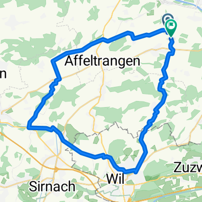
Leaving Weinfelden in Canton Thurgau, the road rises gently in the countryside before descending to Wil. This is where you enter Canton St. Gallen.
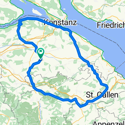
The route undulates as it enters the hilly Toggenburg region. At Ebnat-Kappel, you continue to follow the Thur river upstream along the valley’s flank, taking a charming little road that meanders amid the farms away from the traffic.
The main ascent starts at Neu Sankt Johann and consists of a number of ramps (gradient: 7-8%) through the meadows interspersed with level sections. The pass itself is reached at alt. 1278m and offers views of the Säntis (alt. 2502m), the main peak in the regions which can be accessed via aerial cableway. In fine weather, this peak offers views not only of Switzerland, but also of Germany, Austria, Liechtenstein and France!
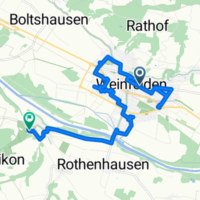
A rapid descent leads to Urnäsch, after which a series of back roads bring you to Herisau, the capital of Canton Appenzell Ausserrhoden. The 40km return leg to Weinfelden is largely downhill.
- -:--
- Dauer
- 123,8 km
- Distanz
- 1.204 m
- Aufstieg
- 1.204 m
- Abstieg
- ---
- Ø-Tempo
- ---
- Max. Höhe

Routenqualität
Wegtypen und Untergründe entlang der Route
Wegtypen
Straße
39,6 km
(32 %)
Ruhige Straße
33,4 km
(27 %)
Untergründe
Befestigt
94,1 km
(76 %)
Asphalt
81,7 km
(66 %)
Befestigt (undefiniert)
12,4 km
(10 %)
Undefiniert
29,7 km
(24 %)
Weiter mit Bikemap
Diese Radroute verwenden, bearbeiten oder herunterladen
Du möchtest Säntis Classic fahren oder sie für deine eigene Reise anpassen? Folgendes kannst du mit dieser Bikemap-Route machen:
Gratis Funktionen
- Speichere diese Route als Favorit oder in einer Sammlung
- Kopiere & plane deine eigene Version dieser Route
- Teile sie in Etappen ein, um eine mehrtägige Tour zu erstellen
- Synchronisiere deine Route mit Garmin oder Wahoo
Premium-Funktionen
Kostenlose Testversion für 3 Tage oder einmalige Zahlung. Mehr über Bikemap Premium.
- Navigiere diese Route auf iOS & Android
- Exportiere eine GPX / KML-Datei dieser Route
- Erstelle deinen individuellen Ausdruck (Jetzt kostenlos ausprobieren)
- Lade diese Route für die Offline-Navigation herunter
Entdecke weitere Premium-Funktionen.
Bikemap Premium aktivierenVon unserer Community
Weinfelden: Andere beliebte Routen, die hier beginnen
 Neugutstrasse 2, Weinfelden nach Amriswilerstrasse 54, Weinfelden
- Distanz
- 47,5 km
- Aufstieg
- 609 m
- Abstieg
- 615 m
- Standort
- Weinfelden, Kanton Thurgau, Schweiz
 Route in Bussnang
- Distanz
- 30,5 km
- Aufstieg
- 494 m
- Abstieg
- 492 m
- Standort
- Weinfelden, Kanton Thurgau, Schweiz
 Friltschen - Herisau - Kreuzlingen - Friltschen CLONED FROM ROUTE 221516
- Distanz
- 115,9 km
- Aufstieg
- 710 m
- Abstieg
- 710 m
- Standort
- Weinfelden, Kanton Thurgau, Schweiz
 thurathlon 2014 velostrecke
- Distanz
- 47,5 km
- Aufstieg
- 479 m
- Abstieg
- 479 m
- Standort
- Weinfelden, Kanton Thurgau, Schweiz
 Frauenfeld-Weinfelden
- Distanz
- 33,6 km
- Aufstieg
- 80 m
- Abstieg
- 80 m
- Standort
- Weinfelden, Kanton Thurgau, Schweiz
 Rund um Weinfelden flach
- Distanz
- 31,5 km
- Aufstieg
- 115 m
- Abstieg
- 115 m
- Standort
- Weinfelden, Kanton Thurgau, Schweiz
 thurathlon 14 laufen kurz(1)/lang(2)
- Distanz
- 11,5 km
- Aufstieg
- 48 m
- Abstieg
- 46 m
- Standort
- Weinfelden, Kanton Thurgau, Schweiz
 Klasse 1Ga Freitag
- Distanz
- 11,5 km
- Aufstieg
- 73 m
- Abstieg
- 47 m
- Standort
- Weinfelden, Kanton Thurgau, Schweiz
In der App öffnen