

Heart of Switzerland
Eine Fahrradroute, die in Altdorf, Canton of Uri, Switzerland beginnt.
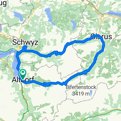
Übersicht
Über diese Route
Featuring almost 50 kilometres of climbing, this loop calls for fitness and a love of adventure.
The road starts climbing the moment you leave Altdorf – moderately as far as Bürglen, birthplace of William Tell. That is where the ascent proper to the Klausen pass starts, one of the classic passes of the Tour de Suisse.
You soon find yourself entering the Schächen valley, which boasts a spectacular waterfall on the far flank.
The road just before Unterschächen features a slight descent for 1.5km – welcome respite before the final 12 kilometres of climbing, where the gradient is never less than 7%. The summit at alt. 1948m is finally reached after 24km of climbing.
The descent amid the cliffs is spectacular. The route flattens out for a few kilometres through the Urnerboden, a high-level valley dotted with farms where time seems to have stopped still.
A few more hairpins and you arrive in Linthal then Glarus. The next challenge is the Pragel pass up a narrow, tranquil road. The first part of the climb is steep, reaching Lake Klöntal ringed by awe-inspiring cliffs after 5km. This level section helps you gather your strength in readiness for the last 10 kilometres of pass road, culminating at alt. 1548m. It is closed to traffic at weekends.
The downhill to Schwyz is steep – thankfully the loop is not in the other direction! The return leg to Altdorf follows the craggy shoreline of Lake Lucerne.
- -:--
- Dauer
- 133,7 km
- Distanz
- 2.611 m
- Aufstieg
- 2.611 m
- Abstieg
- ---
- Ø-Tempo
- ---
- Ø-Tempo

Routenqualität
Wegtypen und Untergründe entlang der Route
Wegtypen
Vielbefahrene Straße
50,7 km
(38 %)
Straße
36,1 km
(27 %)
Untergründe
Befestigt
105,3 km
(79 %)
Unbefestigt
11,5 km
(9 %)
Asphalt
101,9 km
(76 %)
Schotter
6 km
(5 %)
Weiter mit Bikemap
Diese Radroute verwenden, bearbeiten oder herunterladen
Du möchtest Heart of Switzerland fahren oder sie für deine eigene Reise anpassen? Folgendes kannst du mit dieser Bikemap-Route machen:
Gratis Funktionen
- Speichere diese Route als Favorit oder in einer Sammlung
- Kopiere & plane deine eigene Version dieser Route
- Synchronisiere deine Route mit Garmin oder Wahoo
Premium-Funktionen
Kostenlose Testversion für 3 Tage oder einmalige Zahlung. Mehr über Bikemap Premium.
- Navigiere diese Route auf iOS & Android
- Exportiere eine GPX / KML-Datei dieser Route
- Erstelle deinen individuellen Ausdruck (Jetzt kostenlos ausprobieren)
- Lade diese Route für die Offline-Navigation herunter
Entdecke weitere Premium-Funktionen.
Bikemap Premium aktivierenVon unserer Community
Altdorf: Andere beliebte Routen, die hier beginnen
 Altdorf-Klausenpass (1948m)
- Distanz
- 25,1 km
- Aufstieg
- 1.579 m
- Abstieg
- 122 m
- Standort
- Altdorf, Kanton Uri, Schweiz
 Ibergeregg-Pragel-Klausen
- Distanz
- 142,1 km
- Aufstieg
- 3.364 m
- Abstieg
- 3.363 m
- Standort
- Altdorf, Kanton Uri, Schweiz
 klausen pass Pragel pass
- Distanz
- 130,4 km
- Aufstieg
- 2.809 m
- Abstieg
- 2.809 m
- Standort
- Altdorf, Kanton Uri, Schweiz
 Altdorf - Göscheneralp
- Distanz
- 40,1 km
- Aufstieg
- 1.384 m
- Abstieg
- 50 m
- Standort
- Altdorf, Kanton Uri, Schweiz
 Altdorf Unterschächen
- Distanz
- 12,7 km
- Aufstieg
- 608 m
- Abstieg
- 61 m
- Standort
- Altdorf, Kanton Uri, Schweiz
 008 Altdorf - Willerzell, SA 01.08.20
- Distanz
- 47,7 km
- Aufstieg
- 905 m
- Abstieg
- 473 m
- Standort
- Altdorf, Kanton Uri, Schweiz
 Route«1291» Etappe 2: Altdorf – Andermatt
- Distanz
- 37 km
- Aufstieg
- 1.082 m
- Abstieg
- 109 m
- Standort
- Altdorf, Kanton Uri, Schweiz
 Isenthal Bike - 403 SchweizMobil
- Distanz
- 34,2 km
- Aufstieg
- 1.582 m
- Abstieg
- 1.396 m
- Standort
- Altdorf, Kanton Uri, Schweiz
In der App öffnen