
Kazimierz Dolny (Poland)
Eine Fahrradroute, die in Dęblin, Woiwodschaft Lublin, Polen beginnt.
Übersicht
Über diese Route
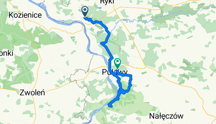
Von Dęblin folgt die Route der Grünen Route Bursztynowy, die zu Beginn sehr gut markiert ist. Allerdings habe ich sie ein paar Kilometer vor Puławy verloren, weshalb ich diesen Streckenabschnitt auf einer stark befahrenen Straße entlang der Weichsel gefahren bin. Von Puławy nach Kazimierz Dolny versuchte ich, dem schwarzen Wanderweg zu folgen, aber an vielen Stellen konnte ich ihn nicht finden. Es lohnt sich, auf diesem Teil der Tour ein Mountainbike dabei zu haben, da die Strecke über Waldwege führt, oft schmal und durch Schluchten, die manchmal ziemlich steil sind. In Kazimierz Dolny lohnt es sich, Zeit zu verbringen und durch diese interessante Stadt zu spazieren. Auf dem Rückweg fuhr ich am Deich entlang der Weichsel und dann bergauf, wo ich wieder an einigen Stellen den Weg nicht ausmachen konnte. Wenn ihr plant, mit dem Zug zurückzufahren, denkt daran, dass der Bahnhof Puławy Miasto heißt, nicht einfach Puławy – das ist ein Güterbahnhof. Google Maps hat mich zum Güterbahnhof geführt, und ich kam dann 3 Minuten zu spät zum Zug ;)
- -:--
- Dauer
- 77,3 km
- Distanz
- 319 m
- Aufstieg
- 291 m
- Abstieg
- ---
- Ø-Tempo
- ---
- Max. Höhe

Routenqualität
Wegtypen und Untergründe entlang der Route
Wegtypen
Ruhige Straße
18,5 km
(24 %)
Straße
15,5 km
(20 %)
Untergründe
Befestigt
36,3 km
(47 %)
Unbefestigt
6,2 km
(8 %)
Asphalt
33,2 km
(43 %)
Natürlicher Untergrund
5,4 km
(7 %)
Weiter mit Bikemap
Diese Radroute verwenden, bearbeiten oder herunterladen
Du möchtest Kazimierz Dolny (Poland) fahren oder sie für deine eigene Reise anpassen? Folgendes kannst du mit dieser Bikemap-Route machen:
Gratis Funktionen
- Speichere diese Route als Favorit oder in einer Sammlung
- Kopiere & plane deine eigene Version dieser Route
- Synchronisiere deine Route mit Garmin oder Wahoo
Premium-Funktionen
Kostenlose Testversion für 3 Tage oder einmalige Zahlung. Mehr über Bikemap Premium.
- Navigiere diese Route auf iOS & Android
- Exportiere eine GPX / KML-Datei dieser Route
- Erstelle deinen individuellen Ausdruck (Jetzt kostenlos ausprobieren)
- Lade diese Route für die Offline-Navigation herunter
Entdecke weitere Premium-Funktionen.
Bikemap Premium aktivierenVon unserer Community
Dęblin: Andere beliebte Routen, die hier beginnen
 Dęblin-Puławy-Kazimierz
- Distanz
- 108,6 km
- Aufstieg
- 197 m
- Abstieg
- 197 m
- Standort
- Dęblin, Woiwodschaft Lublin, Polen
 Wisła Rzeką Strategiczną
- Distanz
- 207,2 km
- Aufstieg
- 251 m
- Abstieg
- 253 m
- Standort
- Dęblin, Woiwodschaft Lublin, Polen
 Dęblin - Kazimierz - Wąwolnica - Dęblin
- Distanz
- 108,6 km
- Aufstieg
- 301 m
- Abstieg
- 302 m
- Standort
- Dęblin, Woiwodschaft Lublin, Polen
 Stężycka 45, Dęblin do Stężycka 45, Dęblin
- Distanz
- 13,9 km
- Aufstieg
- 29 m
- Abstieg
- 27 m
- Standort
- Dęblin, Woiwodschaft Lublin, Polen
 debln pulawy
- Distanz
- 47,6 km
- Aufstieg
- 40 m
- Abstieg
- 37 m
- Standort
- Dęblin, Woiwodschaft Lublin, Polen
 Kazimierz Dolny (Poland)
- Distanz
- 77,3 km
- Aufstieg
- 319 m
- Abstieg
- 291 m
- Standort
- Dęblin, Woiwodschaft Lublin, Polen
 mała pętla Dęblin
- Distanz
- 23,7 km
- Aufstieg
- 44 m
- Abstieg
- 49 m
- Standort
- Dęblin, Woiwodschaft Lublin, Polen
 Generała pilota Józefa Kowalskiego 19, Dęblin do Generała pilota Józefa Kowalskiego 19, Dęblin
- Distanz
- 29,7 km
- Aufstieg
- 44 m
- Abstieg
- 45 m
- Standort
- Dęblin, Woiwodschaft Lublin, Polen
In der App öffnen