

GSO17 - Jamestown Greenway to UNCG
Eine Fahrradroute, die in Jamestown, North Carolina, United States of America beginnt.
Übersicht
Über diese Route
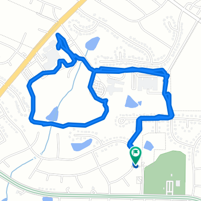
This route starts at the Penny Road environmental center entrance to the Southern Greensboro Greenway. It follows the entire length of the greenway to its terminus at Galimore Dairy Road and then uses surface streets with wide margins or sidewalks to connect to the Starmount Dr. Area. This then provides surface streets to UNCG that have bike lanes or are low traffic areas.
- -:--
- Dauer
- 26,9 km
- Distanz
- 159 m
- Aufstieg
- 134 m
- Abstieg
- ---
- Ø-Tempo
- ---
- Ø-Tempo
Weiter mit Bikemap
Diese Radroute verwenden, bearbeiten oder herunterladen
Du möchtest GSO17 - Jamestown Greenway to UNCG fahren oder sie für deine eigene Reise anpassen? Folgendes kannst du mit dieser Bikemap-Route machen:
Gratis Funktionen
- Speichere diese Route als Favorit oder in einer Sammlung
- Kopiere & plane deine eigene Version dieser Route
- Synchronisiere deine Route mit Garmin oder Wahoo
Premium-Funktionen
Kostenlose Testversion für 3 Tage oder einmalige Zahlung. Mehr über Bikemap Premium.
- Navigiere diese Route auf iOS & Android
- Exportiere eine GPX / KML-Datei dieser Route
- Erstelle deinen individuellen Ausdruck (Jetzt kostenlos ausprobieren)
- Lade diese Route für die Offline-Navigation herunter
Entdecke weitere Premium-Funktionen.
Bikemap Premium aktivierenVon unserer Community
Jamestown: Andere beliebte Routen, die hier beginnen
 GSO17 - Jamestown Greenway to UNCG
- Distanz
- 26,9 km
- Aufstieg
- 159 m
- Abstieg
- 134 m
- Standort
- Jamestown, North Carolina, USA
 luni_Bicentenial
- Distanz
- 33,5 km
- Aufstieg
- 191 m
- Abstieg
- 189 m
- Standort
- Jamestown, North Carolina, USA
 Timberwolf Avenue 3337, High Point to Timberwolf Avenue 3337, High Point
- Distanz
- 5,4 km
- Aufstieg
- 32 m
- Abstieg
- 32 m
- Standort
- Jamestown, North Carolina, USA
 Amazing
- Distanz
- 12,4 km
- Aufstieg
- 83 m
- Abstieg
- 80 m
- Standort
- Jamestown, North Carolina, USA
 East Fork Road 7123, High Point to Tangle Lane 1233, High Point
- Distanz
- 18,8 km
- Aufstieg
- 183 m
- Abstieg
- 191 m
- Standort
- Jamestown, North Carolina, USA
 HP/GBO Greenway
- Distanz
- 20,1 km
- Aufstieg
- 144 m
- Abstieg
- 144 m
- Standort
- Jamestown, North Carolina, USA
 Bicentenial Greenway-home
- Distanz
- 20,1 km
- Aufstieg
- 121 m
- Abstieg
- 93 m
- Standort
- Jamestown, North Carolina, USA
 bike portion of sprint triatholon
- Distanz
- 24,5 km
- Aufstieg
- 105 m
- Abstieg
- 117 m
- Standort
- Jamestown, North Carolina, USA
In der App öffnen