
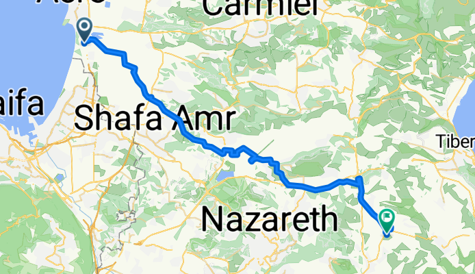
Acre To Kfar Kama 18
Eine Fahrradroute, die in Akko, Northern District, Israel beginnt.
Übersicht
Über diese Route
"Тятэжъмэ Яужыпкъыхэр" "In the Footsteps of the Forefathers": In memory of our ancestors
Cycling along the Circassians' route from Acre to Kfar Kama in 1878.
According to all opinions, Kfar Kama was settled in 1878. The settlers are part of the remains of the Circassian nation that survived the Russian Empire's attempt to annihilate the Circassian people..
In 1864 they were forced to abandon the Caucasus and settle in the Balkans. After 14 years in the Balkans, they were forced to leave again and reached the shores of Acre, where they stayed for a short period, and then settled in Kama.
Goals: 1. Feel and try to achieve the depth and extent of the difficulties experienced by our ancestors on their way to Kfar Kama 2. Appreciate the determination and efforts of our ancestors to ensure the continuity of the Circassian people 3. To strengthen the feeling and recognition of the commitment to this continuity
Designed for Experienced Circassian Cyclists For details: Monir Lavai - Community Center Manager 050-7235939
- -:--
- Dauer
- 53,5 km
- Distanz
- 332 m
- Aufstieg
- 143 m
- Abstieg
- ---
- Ø-Tempo
- ---
- Max. Höhe
Weiter mit Bikemap
Diese Radroute verwenden, bearbeiten oder herunterladen
Du möchtest Acre To Kfar Kama 18 fahren oder sie für deine eigene Reise anpassen? Folgendes kannst du mit dieser Bikemap-Route machen:
Gratis Funktionen
- Speichere diese Route als Favorit oder in einer Sammlung
- Kopiere & plane deine eigene Version dieser Route
- Synchronisiere deine Route mit Garmin oder Wahoo
Premium-Funktionen
Kostenlose Testversion für 3 Tage oder einmalige Zahlung. Mehr über Bikemap Premium.
- Navigiere diese Route auf iOS & Android
- Exportiere eine GPX / KML-Datei dieser Route
- Erstelle deinen individuellen Ausdruck (Jetzt kostenlos ausprobieren)
- Lade diese Route für die Offline-Navigation herunter
Entdecke weitere Premium-Funktionen.
Bikemap Premium aktivierenVon unserer Community
Akko: Andere beliebte Routen, die hier beginnen
 Ako to Roash hanikra
- Distanz
- 35,3 km
- Aufstieg
- 89 m
- Abstieg
- 84 m
- Standort
- Akko, Northern District, Israel
 acres
acres- Distanz
- 3,1 km
- Aufstieg
- 13 m
- Abstieg
- 20 m
- Standort
- Akko, Northern District, Israel
 מסעאופניים17-תחנותרענון
- Distanz
- 76,1 km
- Aufstieg
- 559 m
- Abstieg
- 326 m
- Standort
- Akko, Northern District, Israel
 Acre To Kfar Kama 18
- Distanz
- 53,5 km
- Aufstieg
- 332 m
- Abstieg
- 143 m
- Standort
- Akko, Northern District, Israel
 Unnamed Road to Yehuda Burla Street 6, Acre
- Distanz
- 5,5 km
- Aufstieg
- 72 m
- Abstieg
- 49 m
- Standort
- Akko, Northern District, Israel
 עכו to דרך ללא שם, עין המפרץ
- Distanz
- 63 km
- Aufstieg
- 287 m
- Abstieg
- 289 m
- Standort
- Akko, Northern District, Israel
 מסעף מוסד אחווה, עכו to הראשונים 1, מטולה
- Distanz
- 87,7 km
- Aufstieg
- 4.004 m
- Abstieg
- 3.503 m
- Standort
- Akko, Northern District, Israel
 ako to kinneret
- Distanz
- 47 km
- Aufstieg
- 686 m
- Abstieg
- 896 m
- Standort
- Akko, Northern District, Israel
In der App öffnen