- 7,4 km
- 187 m
- 248 m
- Bohinjska Bistrica, Gemeinde Bohinj, Slowenien
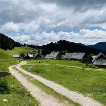
Pokljuka Alpine meadows
Eine Fahrradroute, die in Bohinjska Bistrica, Gemeinde Bohinj, Slowenien beginnt.
Übersicht
Über diese Route
- -:--
- Dauer
- 60,7 km
- Distanz
- 1.008 m
- Aufstieg
- 1.009 m
- Abstieg
- ---
- Ø-Tempo
- ---
- Max. Höhe
Erstellt vor 8 Jahren
Highlights der Route
POIs entlang der Route

Interessanter Ort nach 16,8 km
USKOVNICA MOUNTAIN HUT. Beautiful Uskovnica alpine meadow with many traditional shepherds' huts that are nowadays transformed into idyllic holiday houses. There is a mountain hut at Uskovnica and provides 'first aid' for the hungry and thirsty.

Interessanter Ort nach 18,5 km
PRAPROTNICA MEADOW

Interessanter Ort nach 20,8 km
ZAJAMNIKI MEADOW. Zajamniki Meadow is one of the most beautiful meadows of Poljuka. Here you will find stunning views of the Julian Alps, Mt. Triglav, and Lake Bohinj.

Interessanter Ort nach 22,8 km
KONJSKA DOLINA (Horse Valley) MEADOW

Interessanter Ort nach 24,9 km
JELJE MEADOW

Interessanter Ort nach 32 km
POKLJUKA MARSH. Swamps ("barje") on the Pokljuka plateau lie on the most southern side in entire Europe, and they are still preserved and included in the Natura 2000 system.

Interessanter Ort nach 38,9 km
TOURIST FARM ROCNJEK. An idyllic alpine village situated in the Triglav national park, surrounded by meadows and forests. Gorjuše is the last hamlet before the Pokljuka plateau, entrance to the Kingdom of Zlatorog. It is the perfect starting point for skiers, hikers and mountaineers.
Weiter mit Bikemap
Diese Radroute verwenden, bearbeiten oder herunterladen
Du möchtest Pokljuka Alpine meadows fahren oder sie für deine eigene Reise anpassen? Folgendes kannst du mit dieser Bikemap-Route machen:
Gratis Funktionen
- Speichere diese Route als Favorit oder in einer Sammlung
- Kopiere & plane deine eigene Version dieser Route
- Synchronisiere deine Route mit Garmin oder Wahoo
Premium-Funktionen
Kostenlose Testversion für 3 Tage oder einmalige Zahlung. Mehr über Bikemap Premium.
- Navigiere diese Route auf iOS & Android
- Exportiere eine GPX / KML-Datei dieser Route
- Erstelle deinen individuellen Ausdruck (Jetzt kostenlos ausprobieren)
- Lade diese Route für die Offline-Navigation herunter
Entdecke weitere Premium-Funktionen.
Bikemap Premium aktivierenVon unserer Community
Bohinjska Bistrica: Andere beliebte Routen, die hier beginnen
- Slow ride in Bohinj
- Recording from 22. julij 13:02
- 32,8 km
- 803 m
- 803 m
- Bohinjska Bistrica, Gemeinde Bohinj, Slowenien
- Snail-like route in Bohinjska Bistrica
- 20,1 km
- 146 m
- 155 m
- Bohinjska Bistrica, Gemeinde Bohinj, Slowenien
- Von Bohinjska Bistrica bis Görz
- 106,8 km
- 4.442 m
- 4.872 m
- Bohinjska Bistrica, Gemeinde Bohinj, Slowenien
- Bohinjska Bistrica - Železniki
- 60,7 km
- 1.256 m
- 2.233 m
- Bohinjska Bistrica, Gemeinde Bohinj, Slowenien
- Bohinjer See Runde
- 12,1 km
- 237 m
- 236 m
- Bohinjska Bistrica, Gemeinde Bohinj, Slowenien
- Rudno polje čez Podjelje - Gorelek
- 46,6 km
- 881 m
- 880 m
- Bohinjska Bistrica, Gemeinde Bohinj, Slowenien
- Pot 5 planin
- 35,5 km
- 863 m
- 863 m
- Bohinjska Bistrica, Gemeinde Bohinj, Slowenien
In der App öffnen


