
B2B00212 55404>55104 viaMidtownGreenway/wRiver/LakeSt.Marshall/Hamline
Eine Fahrradroute, die in Minneapolis, Minnesota, Vereinigte Staaten beginnt.
Übersicht
Über diese Route
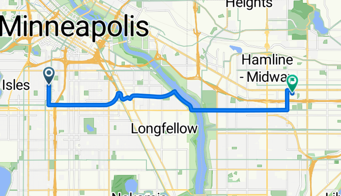
Gehe nach Süden auf der Nicollet zur Midtown Greenway Radweg. Biege links (nach Osten) ab und folge dem Radweg. An der 28. Straße kannst du entweder auf dem Radweg bleiben und die Hiawatha Avenue über die coole Martin Sabo Brücke überqueren (nachts wunderschön) oder du biegst rechts an der 28. Straße ab und überquerst Hiawatha bei der Ampel. Biege rechts ab und fahre weiter auf dem West River Pkwy., entweder auf dem Radweg oder der Straße bis zur Lake Street Brücke. Überquere die Lake Street Brücke und fahre weiter auf der nun in St. Paul liegenden Marshall Avenue. Nimm die Marshall Avenue den Hügel hinauf und fahre weiter bis du die Hamline Avenue erreichst. Biege links in die Hamline ein und folge ihr bis zur University Avenue. Biege rechts in die University Avenue ab und fahre einen Block bis zur Syndicate St. N. Biege rechts in die Syndicate und du hast dein Ziel erreicht.
- -:--
- Dauer
- 12,4 km
- Distanz
- 47 m
- Aufstieg
- 35 m
- Abstieg
- ---
- Ø-Tempo
- 279 m
- Max. Höhe
Routenqualität
Wegtypen und Untergründe entlang der Route
Wegtypen
Radweg
6,8 km
(55 %)
Ruhige Straße
3,1 km
(25 %)
Untergründe
Befestigt
8,8 km
(71 %)
Asphalt
7,4 km
(60 %)
Befestigt (undefiniert)
0,7 km
(6 %)
Highlights der Route
POIs entlang der Route
Interessanter Ort nach 3,5 km
At this point you can either turn right at E. 28th Street and cross Hiawatha at the stop lights or continue on the bike path using the new Martin Sabo bridge.
Weiter mit Bikemap
Diese Radroute verwenden, bearbeiten oder herunterladen
Du möchtest B2B00212 55404>55104 viaMidtownGreenway/wRiver/LakeSt.Marshall/Hamline fahren oder sie für deine eigene Reise anpassen? Folgendes kannst du mit dieser Bikemap-Route machen:
Gratis Funktionen
- Speichere diese Route als Favorit oder in einer Sammlung
- Kopiere & plane deine eigene Version dieser Route
- Synchronisiere deine Route mit Garmin oder Wahoo
Premium-Funktionen
Kostenlose Testversion für 3 Tage oder einmalige Zahlung. Mehr über Bikemap Premium.
- Navigiere diese Route auf iOS & Android
- Exportiere eine GPX / KML-Datei dieser Route
- Erstelle deinen individuellen Ausdruck (Jetzt kostenlos ausprobieren)
- Lade diese Route für die Offline-Navigation herunter
Entdecke weitere Premium-Funktionen.
Bikemap Premium aktivierenVon unserer Community
Minneapolis: Andere beliebte Routen, die hier beginnen
 Loring Park, Minneapolis to Yale Pl, Minneapolis
- Distanz
- 31,4 km
- Aufstieg
- 180 m
- Abstieg
- 181 m
- Standort
- Minneapolis, Minnesota, Vereinigte Staaten
 Willow St, Minneapolis to Spruce Pl, Minneapolis
- Distanz
- 27,5 km
- Aufstieg
- 111 m
- Abstieg
- 103 m
- Standort
- Minneapolis, Minnesota, Vereinigte Staaten
 Lyn-Park Lane North to Lyn-Park Lane North
- Distanz
- 18 km
- Aufstieg
- 183 m
- Abstieg
- 159 m
- Standort
- Minneapolis, Minnesota, Vereinigte Staaten
 W 32nd St, Minneapolis to Yale Pl, Minneapolis
- Distanz
- 14,9 km
- Aufstieg
- 74 m
- Abstieg
- 81 m
- Standort
- Minneapolis, Minnesota, Vereinigte Staaten
 S Sixth St, Minneapolis to Spruce Pl, Minneapolis
- Distanz
- 1,7 km
- Aufstieg
- 6 m
- Abstieg
- 21 m
- Standort
- Minneapolis, Minnesota, Vereinigte Staaten
 Nicollet Island Pavilion Minneapolis downtown bike ride
- Distanz
- 21,2 km
- Aufstieg
- 218 m
- Abstieg
- 215 m
- Standort
- Minneapolis, Minnesota, Vereinigte Staaten
 Spruce Pl, Minneapolis to Loring Park, Minneapolis
- Distanz
- 34,5 km
- Aufstieg
- 117 m
- Abstieg
- 116 m
- Standort
- Minneapolis, Minnesota, Vereinigte Staaten
 Bryant, Minneapolis to 14th Ave S, Minneapolis
- Distanz
- 13,5 km
- Aufstieg
- 59 m
- Abstieg
- 69 m
- Standort
- Minneapolis, Minnesota, Vereinigte Staaten
In der App öffnen