

B2B00192 55102>55404viaShepherdRd/MissBlvd/WRiverPkwy/MidtwnGrnway
Eine Fahrradroute, die in Saint Paul, Minnesota, Vereinigte Staaten beginnt.
Übersicht
Über diese Route
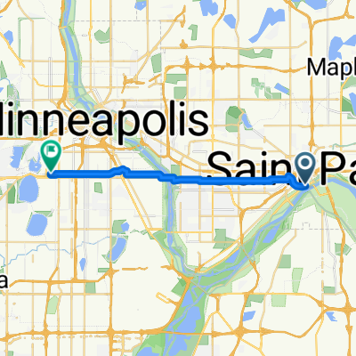
This route is decidedly longer but is far more interesting and faster. Very few stops compared to a cross town route. Take Shepherd Road West along the Mississippi River. You can either ride on the bike path or on the road. Follow Shepherd Rd. past 35E until it becomes East Mississippi River Blvd. Continue on East Mississippi past the Ford Plant. Go under the Ford Pkwy. bridge and make an immediate right hairpin turn up to Ford Pkwy. and cross over the Mississippi on the Ford Bridge. Immediately at the end of the bridge is a path to the right that will take you down to West River Pkwy. Follow West River Pkwy. either on the road or bike path. Pass under Lake Street and continue on. At E.27th Street there is a path up to the Midtown Greenway Bike Trail. Take the bike trail west. At Hiawatha Avenue you can either continue straight ahead and cross with the stop light traffic or proceed on the bike path over the new Martin Sabo bridge. (Very cool at night with blue lights). Continue on the Greenway until you reach Chicago Avenue. Exit up the steps to the street and go north on Chicago to 26th Street and your destination.
- -:--
- Dauer
- 21,8 km
- Distanz
- 131 m
- Aufstieg
- 86 m
- Abstieg
- ---
- Ø-Tempo
- 258 m
- Max. Höhe
Routenqualität
Wegtypen und Untergründe entlang der Route
Wegtypen
Radweg
14,5 km
(67 %)
Straße
5,6 km
(26 %)
Untergründe
Befestigt
13,8 km
(63 %)
Asphalt
12,2 km
(56 %)
Beton
1 km
(5 %)
Highlights der Route
POIs entlang der Route
Interessanter Ort nach 18,9 km
At this point you can continue across Hiawatha to E. 28th Street with the traffic signals or continue on the bike path to the north and over the Martin Sabo bridge.
Weiter mit Bikemap
Diese Radroute verwenden, bearbeiten oder herunterladen
Du möchtest B2B00192 55102>55404viaShepherdRd/MissBlvd/WRiverPkwy/MidtwnGrnway fahren oder sie für deine eigene Reise anpassen? Folgendes kannst du mit dieser Bikemap-Route machen:
Gratis Funktionen
- Speichere diese Route als Favorit oder in einer Sammlung
- Kopiere & plane deine eigene Version dieser Route
- Synchronisiere deine Route mit Garmin oder Wahoo
Premium-Funktionen
Kostenlose Testversion für 3 Tage oder einmalige Zahlung. Mehr über Bikemap Premium.
- Navigiere diese Route auf iOS & Android
- Exportiere eine GPX / KML-Datei dieser Route
- Erstelle deinen individuellen Ausdruck (Jetzt kostenlos ausprobieren)
- Lade diese Route für die Offline-Navigation herunter
Entdecke weitere Premium-Funktionen.
Bikemap Premium aktivierenVon unserer Community
Saint Paul: Andere beliebte Routen, die hier beginnen
 Gateway State Trail
- Distanz
- 30 km
- Aufstieg
- 115 m
- Abstieg
- 69 m
- Standort
- Saint Paul, Minnesota, Vereinigte Staaten
 River Ramble 20
- Distanz
- 29,6 km
- Aufstieg
- 196 m
- Abstieg
- 197 m
- Standort
- Saint Paul, Minnesota, Vereinigte Staaten
 B2B00418 55117>55123 via Cedar, Wabasha, Lexington, Pilot Knob Rd
- Distanz
- 20,8 km
- Aufstieg
- 161 m
- Abstieg
- 156 m
- Standort
- Saint Paul, Minnesota, Vereinigte Staaten
 Como & Phalen Bike Way
- Distanz
- 29 km
- Aufstieg
- 191 m
- Abstieg
- 191 m
- Standort
- Saint Paul, Minnesota, Vereinigte Staaten
 To the River Center
- Distanz
- 17,1 km
- Aufstieg
- 117 m
- Abstieg
- 90 m
- Standort
- Saint Paul, Minnesota, Vereinigte Staaten
 B2B00368 55102 > 55417 via Shepard Rd, Godfrey, Minnehaha, River Pkwy
- Distanz
- 17,8 km
- Aufstieg
- 96 m
- Abstieg
- 119 m
- Standort
- Saint Paul, Minnesota, Vereinigte Staaten
 B2B00629 55102 < 55402 via Summit, River Road, West bank, Downtown
- Distanz
- 15,5 km
- Aufstieg
- 82 m
- Abstieg
- 94 m
- Standort
- Saint Paul, Minnesota, Vereinigte Staaten
 B2B00024 55104 > 55121 via Big Rivers Trail
- Distanz
- 16,8 km
- Aufstieg
- 174 m
- Abstieg
- 174 m
- Standort
- Saint Paul, Minnesota, Vereinigte Staaten
In der App öffnen