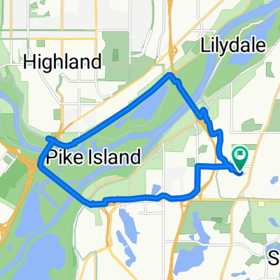
Snail-like route in Mendota Heights
- 14 km
- 325 m
- 325 m
- Mendota Heights, Minnesota, Vereinigte Staaten
Eine Fahrradroute, die in Mendota Heights, Minnesota, Vereinigte Staaten beginnt.
Übersicht
Gehen Sie nach Westen auf der Randolphstraße bis zur Mississippi River Blvd. Es gibt einen Radweg oder die Straße. Biegen Sie rechts ab und fahren Sie weiter auf der Miss. Blvd, bis Sie die Lake Street Bridge erreichen. Überqueren Sie die Lake Street Bridge auf der Nordseite der Brücke. Nach dem Überqueren der Brücke rechts abbiegen und den West River Pkwy nehmen. Radweg oder Fahrbahn. Folgen Sie dem W. River Pkwy unter der Franklin Bridge den Hügel entlang entlang des Mississippi River bis zur S. 4th Street. (Sobald die 35W-Brücke wieder geöffnet ist, würden Sie auf dem West River Parkway weiterfahren, bis Sie die Hennepin Avenue Bridge erreichen. An der Hennepin nehmen Sie eine Fahrradrampe zur Hennepin Avenue und fahren 4 Blocks nach Süden zur 300 Nicollet Mall.) Biegen Sie links ab und fahren Sie den Hügel zur University of Minnesota West Bank hinauf.
An der 19th Avenue rechts abbiegen und zur Washington Ave. S. fahren. Biegen Sie links ab und folgen Sie der Washington Avenue nach Westen, bis Sie die Nicollet Mall erreichen. Biegen Sie links ab, eine Block weiter zur 300 Nicollet Mall.
Routenqualität
Ruhige Straße
3,9 km
(34 %)
Straße
3,8 km
(33 %)
Befestigt
10,4 km
(90 %)
Asphalt
8,4 km
(73 %)
Beton
1,3 km
(11 %)
Highlights der Route
Once the 35W bridge is re-opened you would continue on W.River Parkway until you reach Hennepin Avenue. Go up the bike ramp to Hennepin and go south 4 blocks to 300 Nicollet Mall/Library.
Weiter mit Bikemap
Du möchtest B2B00191 55115>55401viaRandolph/MissBlvd/LkStBridge/WRiverPkwy/WashAv fahren oder sie für deine eigene Reise anpassen? Folgendes kannst du mit dieser Bikemap-Route machen:
Kostenlose Testversion für 3 Tage oder einmalige Zahlung. Mehr über Bikemap Premium.
Entdecke weitere Premium-Funktionen.
Bikemap Premium aktivierenVon unserer Community
In der App öffnen