

bretagna2°stage (ipotesi)
Eine Fahrradroute, die in Roz-sur-Couesnon, Bretagne, Frankreich beginnt.
Übersicht
Über diese Route
Um Zeit aufzuholen, haben wir die Landschaften den touristischen Städten wie Saint Malo vorgezogen... die aber sicherlich ihren Reiz haben... Was meint ihr? Ab welchem Tag würdet ihr uns verlassen?
- -:--
- Dauer
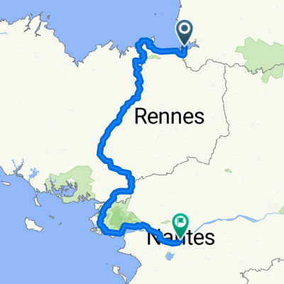
- 243,7 km
- Distanz
- 695 m
- Aufstieg
- 649 m
- Abstieg
- ---
- Ø-Tempo
- ---
- Max. Höhe

Routenqualität
Wegtypen und Untergründe entlang der Route
Wegtypen
Straße
87,7 km
(36 %)
Ruhige Straße
82,8 km
(34 %)
Untergründe
Befestigt
109,6 km
(45 %)
Unbefestigt
12,2 km
(5 %)
Asphalt
109,6 km
(45 %)
Schotter
4,9 km
(2 %)
Highlights der Route
POIs entlang der Route
Foto nach 26,6 km
su roccia granitica, mulino a vento,una statua della MADONNA e cappella annessa ;)
Unterkunft nach 27,2 km
Foto nach 27,2 km
scogliere battute del vento
Foto nach 27,2 km
uccelli e ostriche
Unterkunft nach 57,3 km
camping minicipal
Foto nach 58,2 km
città medioevale con 3km di bastioni
Fahrrad-Service nach 59,1 km
Foto nach 70,4 km
st-malo
Foto nach 97,1 km
forte a picco sul mare ,ponti levatoi
Foto nach 100 km
falesie ..vera aria bretagna.....battute dal vento!!!!!!!!!!
Foto nach 100 km
uno dei 5 fari più potenti della francia
Fahrrad-Service nach 102,1 km
Unterkunft nach 102,7 km
camping municipale
Unterkunft nach 104,9 km
pont letang
Unterkunft nach 131,1 km
camping municipal
Interessanter Ort nach 143,9 km
riserva naturale saint brieuc
Fahrrad-Service nach 146,1 km
Interessanter Ort nach 147,1 km
possibile fermata
Unterkunft nach 150,9 km
camping le lay eouzan
Unterkunft nach 152,5 km
camping des rosaires
Unterkunft nach 152,5 km
camp. mouette
Unterkunft nach 162,1 km
camping mounicipal de fauvet
Foto nach 172,9 km
scogliere più alte della bretagna
Interessanter Ort nach 178,1 km
punto in cui la resistenza francese fece allontanare centinaia di aviatori e agenti
Unterkunft nach 186,5 km
campground la pepinier
Foto nach 190,1 km
abbazia de beaupont
Unterkunft nach 190,2 km
municipal de cruckin (caro??)
Foto nach 192,2 km
Foto nach 193 km
paintpol festival del mare 11-12-12-agosto museo del mare
Fahrrad-Service nach 199,8 km
Unterkunft nach 200,8 km
camping municipal de kermanguer (tariffe molto buone??)
Unterkunft nach 233,2 km
camping municipal les deux rives
Unterkunft nach 237,1 km
camping Abri cotier
Unterkunft nach 237,1 km
camping municipal de ille grande
Interessanter Ort nach 237,1 km
dolmen
Unterkunft nach 242,1 km
camping municipal ernest renan
Unterkunft nach 243,7 km
camping municipal de landrellec
Interessanter Ort nach 243,7 km
scogliere di granito
Interessanter Ort nach 243,7 km
sito naturalisrico de bringuiller
Weiter mit Bikemap
Diese Radroute verwenden, bearbeiten oder herunterladen
Du möchtest bretagna2°stage (ipotesi) fahren oder sie für deine eigene Reise anpassen? Folgendes kannst du mit dieser Bikemap-Route machen:
Gratis Funktionen
- Speichere diese Route als Favorit oder in einer Sammlung
- Kopiere & plane deine eigene Version dieser Route
- Teile sie in Etappen ein, um eine mehrtägige Tour zu erstellen
- Synchronisiere deine Route mit Garmin oder Wahoo
Premium-Funktionen
Kostenlose Testversion für 3 Tage oder einmalige Zahlung. Mehr über Bikemap Premium.
- Navigiere diese Route auf iOS & Android
- Exportiere eine GPX / KML-Datei dieser Route
- Erstelle deinen individuellen Ausdruck (Jetzt kostenlos ausprobieren)
- Lade diese Route für die Offline-Navigation herunter
Entdecke weitere Premium-Funktionen.
Bikemap Premium aktivierenVon unserer Community
Roz-sur-Couesnon: Andere beliebte Routen, die hier beginnen
 Mont Saint Michel - Roscff
- Distanz
- 348,7 km
- Aufstieg
- 822 m
- Abstieg
- 814 m
- Standort
- Roz-sur-Couesnon, Bretagne, Frankreich
 2: Mont St Michel to Saintes
- Distanz
- 384 km
- Aufstieg
- 617 m
- Abstieg
- 622 m
- Standort
- Roz-sur-Couesnon, Bretagne, Frankreich
 Le Mont Saint Michel nach Saint-Malo
- Distanz
- 47,7 km
- Aufstieg
- 95 m
- Abstieg
- 137 m
- Standort
- Roz-sur-Couesnon, Bretagne, Frankreich
 bretagna2°stage (ipotesi)
- Distanz
- 243,7 km
- Aufstieg
- 695 m
- Abstieg
- 649 m
- Standort
- Roz-sur-Couesnon, Bretagne, Frankreich
 Mont Saint Michel-Nantes
- Distanz
- 416,8 km
- Aufstieg
- 2.271 m
- Abstieg
- 2.263 m
- Standort
- Roz-sur-Couesnon, Bretagne, Frankreich
 Le Mont-Saint-Michelà Domfront V43/V40
- Distanz
- 87,5 km
- Aufstieg
- 525 m
- Abstieg
- 408 m
- Standort
- Roz-sur-Couesnon, Bretagne, Frankreich
 Le Mont-Saint-Michel - Le Vivier-sur-Mer
- Distanz
- 28,7 km
- Aufstieg
- 5 m
- Abstieg
- 27 m
- Standort
- Roz-sur-Couesnon, Bretagne, Frankreich
 La Régalante
- Distanz
- 284,3 km
- Aufstieg
- 1.545 m
- Abstieg
- 1.542 m
- Standort
- Roz-sur-Couesnon, Bretagne, Frankreich
In der App öffnen