

The water route
Eine Fahrradroute, die in Bled, Občina Bled, Slowenien beginnt.
Übersicht
Über diese Route
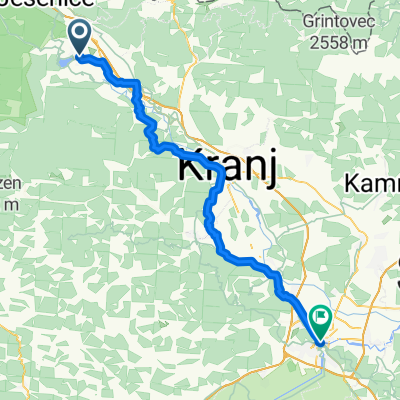
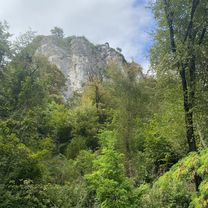
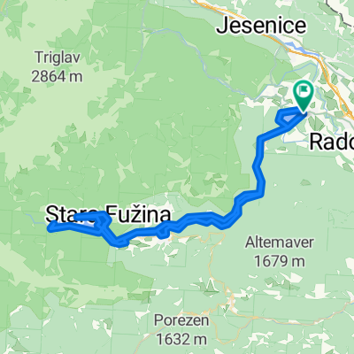
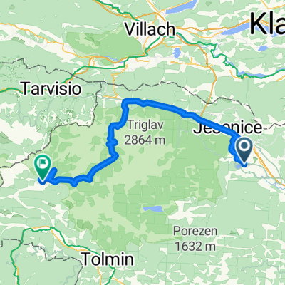
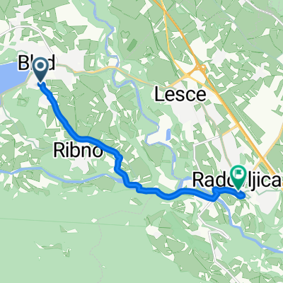
Durch die kleinen Dörfer, den Schildern nach Jesenice auf der Hauptstraße folgend, ist der erste Halt die Vintgar-Schlucht. Eine erstaunliche Gletscherschlucht mit kristallklarem Wasser, am besten ist es, früh dort zu sein, vor 9 Uhr morgens im Sommer, da später viele Touristenbusse kommen. Wenn du die Schlucht verlässt, folge der Hauptstraße nach Jesenice, es ist ein schöner Pass durch zwei Hügel und eine schnell kurvige Straße unter der Autobahn über die Stadt, wo du hindurchfahren kannst, um am Krankenhaus wieder abzubiegen, um den Radweg zu erreichen oder an der äußeren Straße zu bleiben, um das Stadtzentrum zu umgehen. Der Radweg ist gut gepflegt und verläuft entlang der Autobahn durch den Wald. Einmal in Mojstrana den Schildern nach Slap Pericnik folgen, du wirst auf der rechten Seite eine Kletterwand und das Touristeninformationszentrum auf der rechten Seite sehen, während du in den Nationalpark fährst. Das Büro ist großartig für die Geschichte der Gegend, Karten und Informationen über öffentliche Verkehrsanbindungen. Der Wasserfall ist 5 km von der Stadt entfernt, auf Schotterstraße in den Park hinein, sobald du den Wasserfallbereich erreichst, gibt es eine kurze Wanderung zu den Fällen, ein unglaublicher Ort für ein Picknick. Die Rückroute beginnt mit einem steilen, kurvigen Anstieg, während im Sommer die Bäume die Straße so gut beschatten, dass es bis zum Gipfel kaum einen Wind gibt. Aber es lohnt sich, denn du saust ins Tal und das spektakulärste Krma-Tal öffnet sich vor dir. Ich bin mehrmals fast gestürzt wegen der Ablenkung, das Restaurant hier hat möglicherweise eine der besten Aussichten der Welt mit den fairsten Preisen. Die Rückfahrt nach Bled erfolgt über ruhige Waldstraßen mit Bächen und Flüssen, die die Bäume säumen, perfekte Glückseligkeit, besonders an einem heißen Tag. Es gibt mehrere Stellen, um im Fluss zu schwimmen, bevor der letzte Anstieg von Krnica kommt und die atemberaubende Aussicht, während du zurück nach Bled fährst.
- -:--
- Dauer
- 64,3 km
- Distanz
- 797 m
- Aufstieg
- 798 m
- Abstieg
- ---
- Ø-Tempo
- ---
- Max. Höhe

Routenqualität
Wegtypen und Untergründe entlang der Route
Wegtypen
Straße
39,2 km
(61 %)
Ruhige Straße
14,8 km
(23 %)
Untergründe
Befestigt
56,5 km
(88 %)
Unbefestigt
1,9 km
(3 %)
Asphalt
55,9 km
(87 %)
Schotter
1,3 km
(2 %)
Highlights der Route
POIs entlang der Route
Interessanter Ort nach 3,2 km
Vintagar Gorge

Interessanter Ort nach 34,8 km
Waterfall Pericnik

Unterkunft nach 45,4 km
Gostilna, apartmaji, prevozi Psnak Janez Lipovec s.p.
Weiter mit Bikemap
Diese Radroute verwenden, bearbeiten oder herunterladen
Du möchtest The water route fahren oder sie für deine eigene Reise anpassen? Folgendes kannst du mit dieser Bikemap-Route machen:
Gratis Funktionen
- Speichere diese Route als Favorit oder in einer Sammlung
- Kopiere & plane deine eigene Version dieser Route
- Synchronisiere deine Route mit Garmin oder Wahoo
Premium-Funktionen
Kostenlose Testversion für 3 Tage oder einmalige Zahlung. Mehr über Bikemap Premium.
- Navigiere diese Route auf iOS & Android
- Exportiere eine GPX / KML-Datei dieser Route
- Erstelle deinen individuellen Ausdruck (Jetzt kostenlos ausprobieren)
- Lade diese Route für die Offline-Navigation herunter
Entdecke weitere Premium-Funktionen.
Bikemap Premium aktivierenVon unserer Community
Bled: Andere beliebte Routen, die hier beginnen
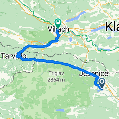
 Bled - Tarvisio
- Distanz
- 63,8 km
- Aufstieg
- 899 m
- Abstieg
- 1.102 m
- Standort
- Bled, Občina Bled, Slowenien
 Prešernova cesta, Bled to Bahnhofplatz, Villach
- Distanz
- 84,3 km
- Aufstieg
- 1.506 m
- Abstieg
- 1.509 m
- Standort
- Bled, Občina Bled, Slowenien
 Jesenice - Pontebba
- Distanz
- 67,4 km
- Aufstieg
- 2.172 m
- Abstieg
- 2.173 m
- Standort
- Bled, Občina Bled, Slowenien
 Savska cesta, Bled až Kolodvorska cesta, Bled
- Distanz
- 5,3 km
- Aufstieg
- 96 m
- Abstieg
- 53 m
- Standort
- Bled, Občina Bled, Slowenien
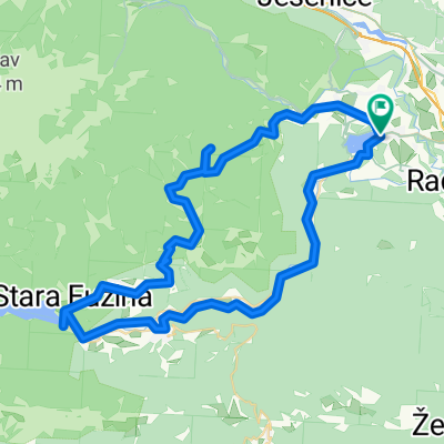
 Route to Bohinjsko jezero
- Distanz
- 29,8 km
- Aufstieg
- 921 m
- Abstieg
- 827 m
- Standort
- Bled, Občina Bled, Slowenien
 Biking from Bled to Bohinj
- Distanz
- 77,2 km
- Aufstieg
- 485 m
- Abstieg
- 487 m
- Standort
- Bled, Občina Bled, Slowenien
 Pontebba - Bovec
- Distanz
- 87,8 km
- Aufstieg
- 2.695 m
- Abstieg
- 2.737 m
- Standort
- Bled, Občina Bled, Slowenien
 Želeška cesta, Bled to Linhartov trg, Radovljica
- Distanz
- 7,3 km
- Aufstieg
- 148 m
- Abstieg
- 169 m
- Standort
- Bled, Občina Bled, Slowenien
In der App öffnen