

B2B00276 55125>55112viaRadio/Inwood/Ideal/OlsonLk/Demont/Gatewy/Water/CtyE/Cent/VadLk/N.Owasso/Vict/CtyE
Eine Fahrradroute, die in Woodbury, Minnesota, Vereinigte Staaten beginnt.
Übersicht
Über diese Route
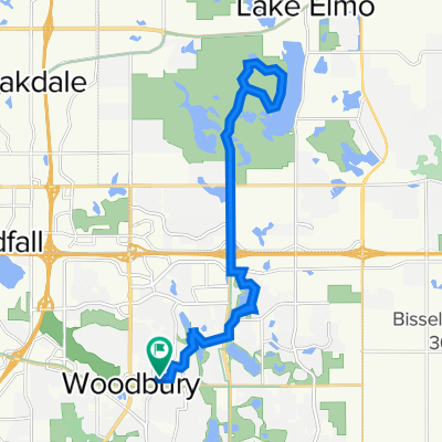
Take Radio Drive north where it becomes Inwood Avenue. Continue on Inwood until you reach Stillwater Blvd (6). Turn left on Stillwater Blvd to Ideal Avenue North. Ideal becomes Olson Lake Trail. Follow Olson Lake Trail around the lake to 50th St. N. Turn right. The road curves to the left and becomes Demontreville Trail N. Follow Demontreville Trail around the lake until you reach Highlands Trail North. Turn left up the hill to Hytrail Av. N and turn left. Follow around until you reach the bike path on your left next to a parking lot. Take this trail to the Gateway Trail. It goes through a little forest and suddenly comes out on the Gateway. Turn right on the Gateway and go through the tunnel under Highway 36. Just past the tunnel turn to the left off the trail to a hairpin turn up to a gravel parking lot. Follow the road (60th St.N) out to Hilton Trail. Turn right on Hilton Trail and turn left at the next intersection, 62nd St. North. Take 62nd to Warner Avenue. Take Warner Avenue to 75th St. N/Stillwater Road. Turn left and follow Stillwater Road through Mahtomedi until you reach Wildwood Road/244. Turn left and continue on Wildwood/244 past Wildwood Pond and up the hill where the road become County Road E. Follow County Road E passing White Bear Avenue, Highway 61, 35E. At Centerville Road turn left. Follow Centerville Road. At the next intersection Centerville becomes Vadnais Blvd. Go straight ahead on Vadnais Blvd. around Lake Vadnais. The road curves around the lake through a forest and through the lake. Up the hill is Rice Street. Turn left at Rice Street and cross over 694. At North Owasso Blvd. turn right. Follow North Owasso past Lake Owasso on your left and continue around the lake until you reach Victoria. Turn right on Victoria Street. Follow Victoria around until you reach County Road E West. Turn left and continue on County Road E to your destination.
- -:--
- Dauer
- 33,1 km
- Distanz
- 124 m
- Aufstieg
- 150 m
- Abstieg
- ---
- Ø-Tempo
- 315 m
- Max. Höhe
Routenqualität
Wegtypen und Untergründe entlang der Route
Wegtypen
Straße
9 km
(27 %)
Ruhige Straße
8,2 km
(25 %)
Untergründe
Befestigt
18,3 km
(55 %)
Asphalt
16,4 km
(49 %)
Befestigt (undefiniert)
1,7 km
(5 %)
Weiter mit Bikemap
Diese Radroute verwenden, bearbeiten oder herunterladen
Du möchtest B2B00276 55125>55112viaRadio/Inwood/Ideal/OlsonLk/Demont/Gatewy/Water/CtyE/Cent/VadLk/N.Owasso/Vict/CtyE fahren oder sie für deine eigene Reise anpassen? Folgendes kannst du mit dieser Bikemap-Route machen:
Gratis Funktionen
- Speichere diese Route als Favorit oder in einer Sammlung
- Kopiere & plane deine eigene Version dieser Route
- Synchronisiere deine Route mit Garmin oder Wahoo
Premium-Funktionen
Kostenlose Testversion für 3 Tage oder einmalige Zahlung. Mehr über Bikemap Premium.
- Navigiere diese Route auf iOS & Android
- Exportiere eine GPX / KML-Datei dieser Route
- Erstelle deinen individuellen Ausdruck (Jetzt kostenlos ausprobieren)
- Lade diese Route für die Offline-Navigation herunter
Entdecke weitere Premium-Funktionen.
Bikemap Premium aktivierenVon unserer Community
Woodbury: Andere beliebte Routen, die hier beginnen
 1208 St Johns Dr, Woodbury to 1208 St Johns Dr, Woodbury
- Distanz
- 8 km
- Aufstieg
- 26 m
- Abstieg
- 28 m
- Standort
- Woodbury, Minnesota, Vereinigte Staaten
 Afton Ride
- Distanz
- 51,2 km
- Aufstieg
- 290 m
- Abstieg
- 304 m
- Standort
- Woodbury, Minnesota, Vereinigte Staaten
 B2B00600 55125>55101 via Upper Afton Rd, Mounds Blvd, 6th St E
- Distanz
- 11,2 km
- Aufstieg
- 86 m
- Abstieg
- 170 m
- Standort
- Woodbury, Minnesota, Vereinigte Staaten
 Lake Elmo Ride
- Distanz
- 24,1 km
- Aufstieg
- 113 m
- Abstieg
- 113 m
- Standort
- Woodbury, Minnesota, Vereinigte Staaten
 B2B00288 55125>55344 via Mndt Hght Rd, 494, 86th St
- Distanz
- 46,8 km
- Aufstieg
- 248 m
- Abstieg
- 283 m
- Standort
- Woodbury, Minnesota, Vereinigte Staaten
 Neighborhood loop
- Distanz
- 19,5 km
- Aufstieg
- 114 m
- Abstieg
- 113 m
- Standort
- Woodbury, Minnesota, Vereinigte Staaten
 B2B00915 55125>55115 viaLakeRd./CenturyAv/HudsonBlvd/Helmo/Ideal/Olson/Demontr/Hilton
- Distanz
- 20,8 km
- Aufstieg
- 115 m
- Abstieg
- 104 m
- Standort
- Woodbury, Minnesota, Vereinigte Staaten
 Slow ride in Woodbury
- Distanz
- 7,8 km
- Aufstieg
- 101 m
- Abstieg
- 106 m
- Standort
- Woodbury, Minnesota, Vereinigte Staaten
In der App öffnen