

Monte Joanaz
Eine Fahrradroute, die in Pulfero, Friuli Venezia Giulia, Italy beginnt.
Übersicht
Über diese Route
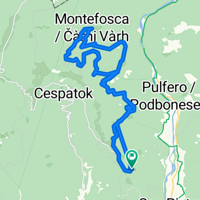
L’itinerario è dedicato agli escursionisti e parte dal pae- sino di Tamoris, ai piedi del monte Joanaz. Da Tamoris si prende la strada asfaltata in salita che porta verso Mon- tefosca. Giunti in prossimità del monumento Madonnina del Dom a 960 mt s.l.m. si imbocca la strada bianca che sale a destra e si percorre no in cima al monte. C’è la possibilità di arrivare in cima anche percorrendo il sen- tiero che costeggia la strada a destra. Arrivati in cima si imbocca il sentiero CAI che scende a sud verso valle e giunti alla strada bianca la si percorre verso destra in discesa no a tornare a Tamoris.
This itinerary is dedicated to excursionists and it starts from the village of Tamoris at the bottom of mount Joanaz. From Tamoris take the paved road that goes uphill to Montefosca. When arrived by the monument Madonnina del Dom at about 960 mt above sea level, take the white road that goes uphill on the right that lead you all the way to the top of the mountain. It is possible to reach the top also if you take the way that goes along road on the right. When arrived to the top, take the path CAI that leads you down to the South until you reach the white road. Con- tinue downhill on the right side of the white road in order to return to the village of Tamoris.
- -:--
- Dauer
- 9,1 km
- Distanz
- 374 m
- Aufstieg
- 372 m
- Abstieg
- ---
- Ø-Tempo
- ---
- Ø-Tempo

Weiter mit Bikemap
Diese Radroute verwenden, bearbeiten oder herunterladen
Du möchtest Monte Joanaz fahren oder sie für deine eigene Reise anpassen? Folgendes kannst du mit dieser Bikemap-Route machen:
Gratis Funktionen
- Speichere diese Route als Favorit oder in einer Sammlung
- Kopiere & plane deine eigene Version dieser Route
- Synchronisiere deine Route mit Garmin oder Wahoo
Premium-Funktionen
Kostenlose Testversion für 3 Tage oder einmalige Zahlung. Mehr über Bikemap Premium.
- Navigiere diese Route auf iOS & Android
- Exportiere eine GPX / KML-Datei dieser Route
- Erstelle deinen individuellen Ausdruck (Jetzt kostenlos ausprobieren)
- Lade diese Route für die Offline-Navigation herunter
Entdecke weitere Premium-Funktionen.
Bikemap Premium aktivierenVon unserer Community
Pulfero: Andere beliebte Routen, die hier beginnen
 Via Specognis 8, Pulfero a Via Specognis 8, Pulfero
- Distanz
- 44,7 km
- Aufstieg
- 1.883 m
- Abstieg
- 1.888 m
- Standort
- Pulfero, Friaul-Venetien, Italien
 Spignon - Torreano - Valle - Faedis - Attimis - Subit -
- Distanz
- 99,7 km
- Aufstieg
- 1.913 m
- Abstieg
- 1.916 m
- Standort
- Pulfero, Friaul-Venetien, Italien
 Stupizza Podbela C.ra Monte Mia
- Distanz
- 23,7 km
- Aufstieg
- 890 m
- Abstieg
- 107 m
- Standort
- Pulfero, Friaul-Venetien, Italien
 valliinrosamtb3
- Distanz
- 11,9 km
- Aufstieg
- 478 m
- Abstieg
- 479 m
- Standort
- Pulfero, Friaul-Venetien, Italien
 loch - matajiur mtg via cai 725 e cai 750 rientro per montemaggiore
- Distanz
- 28,1 km
- Aufstieg
- 1.315 m
- Abstieg
- 1.326 m
- Standort
- Pulfero, Friaul-Venetien, Italien
 Cividale - Togliano - ZIracco - San Mauro - Orsaria - Ipplis
- Distanz
- 52,1 km
- Aufstieg
- 162 m
- Abstieg
- 159 m
- Standort
- Pulfero, Friaul-Venetien, Italien
 Spignon
- Distanz
- 26 km
- Aufstieg
- 656 m
- Abstieg
- 656 m
- Standort
- Pulfero, Friaul-Venetien, Italien
 Route to Via Podvarschis 19, 33046 Pulfero
- Distanz
- 94,5 km
- Aufstieg
- 5.058 m
- Abstieg
- 5.016 m
- Standort
- Pulfero, Friaul-Venetien, Italien
In der App öffnen