

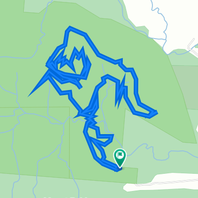
Day 2: Lake Tinaroo Circuit
Eine Fahrradroute, die in Atherton, State of Queensland, Australien beginnt.
Übersicht
Über diese Route
The Tinaroo loop is a mixture of sealed and dirt rd and circumnavigates the tropical paradise of lake Tinaroo. If you would like to do some extra kms and experience some elevated views you can spend an hours or so ascending up Lamb’s range. There is a turn off to the Lambs Range at the start of the lake circuit. Cathedral Figtree is also worth a look. It is located at the start of the circuit as well and it is well signposted. Stop at the Tinaroo village for food and the strawberry farm for ice cream. The road back to Yungaburra on the last part of the circuit has only a small cycling shoulder. You will need to ride this road for about 10km to get back to Yungaburra.
- -:--
- Dauer
- 71,8 km
- Distanz
- 650 m
- Aufstieg
- 649 m
- Abstieg
- ---
- Ø-Tempo
- ---
- Max. Höhe
Weiter mit Bikemap
Diese Radroute verwenden, bearbeiten oder herunterladen
Du möchtest Day 2: Lake Tinaroo Circuit fahren oder sie für deine eigene Reise anpassen? Folgendes kannst du mit dieser Bikemap-Route machen:
Gratis Funktionen
- Speichere diese Route als Favorit oder in einer Sammlung
- Kopiere & plane deine eigene Version dieser Route
- Synchronisiere deine Route mit Garmin oder Wahoo
Premium-Funktionen
Kostenlose Testversion für 3 Tage oder einmalige Zahlung. Mehr über Bikemap Premium.
- Navigiere diese Route auf iOS & Android
- Exportiere eine GPX / KML-Datei dieser Route
- Erstelle deinen individuellen Ausdruck (Jetzt kostenlos ausprobieren)
- Lade diese Route für die Offline-Navigation herunter
Entdecke weitere Premium-Funktionen.
Bikemap Premium aktivierenVon unserer Community
Atherton: Andere beliebte Routen, die hier beginnen
 Atherton Herberton
- Distanz
- 20,1 km
- Aufstieg
- 340 m
- Abstieg
- 245 m
- Standort
- Atherton, State of Queensland, Australien
 22-01-25 Ath mtb, 1,6,1,ft, rd
- Distanz
- 8,7 km
- Aufstieg
- 224 m
- Abstieg
- 205 m
- Standort
- Atherton, State of Queensland, Australien
 Atherton Tablelands Rail Trail, Atherton to 24 Albrecht Street, Atherton
- Distanz
- 7,6 km
- Aufstieg
- 112 m
- Abstieg
- 114 m
- Standort
- Atherton, State of Queensland, Australien
 21-12-17 Ath mtb 1,6,7,6,1,rd
- Distanz
- 11 km
- Aufstieg
- 191 m
- Abstieg
- 172 m
- Standort
- Atherton, State of Queensland, Australien
 Day 4: Yungaburra to Millaa Millaa (The Falls Tea House)
- Distanz
- 73,8 km
- Aufstieg
- 782 m
- Abstieg
- 638 m
- Standort
- Atherton, State of Queensland, Australien
 Easy ride in Atherton
- Distanz
- 16,6 km
- Aufstieg
- 142 m
- Abstieg
- 139 m
- Standort
- Atherton, State of Queensland, Australien
 Rifle Range Road, Atherton to Rifle Range Road, Atherton
- Distanz
- 7,8 km
- Aufstieg
- 221 m
- Abstieg
- 223 m
- Standort
- Atherton, State of Queensland, Australien
 Day 3: Lake Eachem, Curtain Fig Tree and Malanda Falls Loop CLONED FROM ROUTE 437914
- Distanz
- 44,9 km
- Aufstieg
- 475 m
- Abstieg
- 475 m
- Standort
- Atherton, State of Queensland, Australien
In der App öffnen