

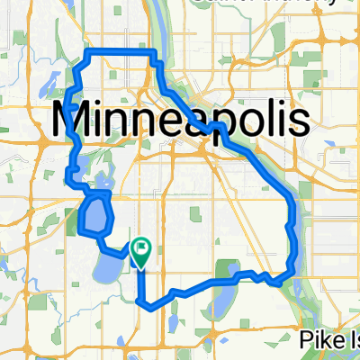
B2B00377 55450 > 55454 via Minnehaha, LRT trail
Eine Fahrradroute, die in Richfield, Minnesota, United States of America beginnt.
Übersicht
Über diese Route
1. Head north on 34th to 54th St.
2. Take a right onto 54th St and head east to Minnehaha.
-
Take Minnehaha Ave's bike lane northwest to Lake Street.
-
Cross Lake Street as Minnehaha Ave changes to 26th Ave S and continue north to 26th Street.
At this point you can either continue on 26th all the way through to Riverside and 26th. 26th is safe, but there is no bike lane. The route that is mapped is on more bike paths, as follows
-
Take a left onto 26th St. and look for the light rail trail bike path (which appears right before Hiawatha Ave).
-
Take a right onto the trail, and follow the path alongside the Light Rail to the Cedar/Riverside station.
7. Just past the Cedar/Riverside station, take a right onto 15, and a quick right onto 6th.
8. Follow 6th to 20th and take a left.
9. Take the bike lane on 20th to Riverside, and take a right.
10. Riverside sometimes has high traffic so you can either walk your bike on the sidewalk the last few blocks or choose to bike up to Fairview.
- -:--
- Dauer
- 12,9 km
- Distanz
- 14 m
- Aufstieg
- 11 m
- Abstieg
- ---
- Ø-Tempo
- 257 m
- Ø-Tempo
Routenqualität
Wegtypen und Untergründe entlang der Route
Wegtypen
Ruhige Straße
5,3 km
(41 %)
Straße
2,7 km
(21 %)
Untergründe
Befestigt
7,3 km
(56 %)
Asphalt
4,5 km
(35 %)
Befestigt (undefiniert)
1,7 km
(13 %)
Weiter mit Bikemap
Diese Radroute verwenden, bearbeiten oder herunterladen
Du möchtest B2B00377 55450 > 55454 via Minnehaha, LRT trail fahren oder sie für deine eigene Reise anpassen? Folgendes kannst du mit dieser Bikemap-Route machen:
Gratis Funktionen
- Speichere diese Route als Favorit oder in einer Sammlung
- Kopiere & plane deine eigene Version dieser Route
- Synchronisiere deine Route mit Garmin oder Wahoo
Premium-Funktionen
Kostenlose Testversion für 3 Tage oder einmalige Zahlung. Mehr über Bikemap Premium.
- Navigiere diese Route auf iOS & Android
- Exportiere eine GPX / KML-Datei dieser Route
- Erstelle deinen individuellen Ausdruck (Jetzt kostenlos ausprobieren)
- Lade diese Route für die Offline-Navigation herunter
Entdecke weitere Premium-Funktionen.
Bikemap Premium aktivierenVon unserer Community
Richfield: Andere beliebte Routen, die hier beginnen
 the Bike & Bistro's premiere tour
- Distanz
- 6,7 km
- Aufstieg
- 26 m
- Abstieg
- 9 m
- Standort
- Richfield, Minnesota, USA
 31 Miles South to North, to Victory Memorial & Minnehaha
- Distanz
- 50,9 km
- Aufstieg
- 124 m
- Abstieg
- 124 m
- Standort
- Richfield, Minnesota, USA
 B2B00114 55409 >55414 via Park Ave and stone arch bridge
- Distanz
- 9 km
- Aufstieg
- 48 m
- Abstieg
- 57 m
- Standort
- Richfield, Minnesota, USA
 B2B00056 55407>55122 via Mnnhaha Pwy, Bg Rvrs Trl
- Distanz
- 17,7 km
- Aufstieg
- 99 m
- Abstieg
- 109 m
- Standort
- Richfield, Minnesota, USA
 Perfect Circle Minneapolis Bike Route
- Distanz
- 36,4 km
- Aufstieg
- 117 m
- Abstieg
- 117 m
- Standort
- Richfield, Minnesota, USA
 B2B00920 55407>55438 via Portland, Mnnha Pwy, Logan, Hylund Prk
- Distanz
- 23,7 km
- Aufstieg
- 98 m
- Abstieg
- 95 m
- Standort
- Richfield, Minnesota, USA
 Day 1 Lag 3
- Distanz
- 106,3 km
- Aufstieg
- 327 m
- Abstieg
- 359 m
- Standort
- Richfield, Minnesota, USA
 30 miler
- Distanz
- 48,5 km
- Aufstieg
- 308 m
- Abstieg
- 310 m
- Standort
- Richfield, Minnesota, USA
In der App öffnen